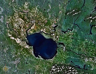
Lac Saint-Jean is a large, relatively shallow lake in south-central Quebec, Canada, in the Laurentian Highlands. It is situated 206 km (128 mi) north of the Saint Lawrence River, into which it drains via the Saguenay River. It covers an area of 1,053 km2 (407 sq mi), and is 63.1 m (207 ft) at its deepest point. Its name in the Innu language is Piekuakamu.

Saguenay is a city in the Saguenay–Lac-Saint-Jean region of Quebec, Canada, on the Saguenay River, about 200 kilometres (120 mi) north of Quebec City by overland route. It is about 126 kilometres (78 mi) upriver and northwest of Tadoussac, located at the confluence with the St. Lawrence River. It was formed in 2002 by merging the cities of Chicoutimi and Jonquière and the town of La Baie. Chicoutimi was founded by French colonists in 1676.

Jonquière is a borough (arrondissement) of the city of Saguenay in the Saguenay–Lac-Saint-Jean region of Quebec, Canada. It is located on the Saguenay River, near the borough of Chicoutimi.

Soil liquefaction occurs when a cohesionless saturated or partially saturated soil substantially loses strength and stiffness in response to an applied stress such as shaking during an earthquake or other sudden change in stress condition, in which material that is ordinarily a solid behaves like a liquid. In soil mechanics, the term "liquefied" was first used by Allen Hazen in reference to the 1918 failure of the Calaveras Dam in California. He described the mechanism of flow liquefaction of the embankment dam as:
If the pressure of the water in the pores is great enough to carry all the load, it will have the effect of holding the particles apart and of producing a condition that is practically equivalent to that of quicksand... the initial movement of some part of the material might result in accumulating pressure, first on one point, and then on another, successively, as the early points of concentration were liquefied.

La Baie is one of three boroughs in the city of Saguenay, Quebec, Canada. It was created during Quebec's municipal reorganization in 2002. From 1976 to 2001, it was known as the Town of La Baie, a municipality composed of the Grande-Baie, Bagotville and Port-Alfred sectors.
Quick clay, also known as Leda clay and Champlain Sea clay in Canada, is any of several distinctively sensitive glaciomarine clays found in Canada, Norway, Russia, Sweden, Finland, the United States and other locations around the world. The clay is so unstable that when a mass of quick clay is subjected to sufficient stress, the material behavior may drastically change from that of a particulate material to that of a watery fluid. Landslides occur because of the sudden soil liquefaction caused by external sollicitations such as vibrations induced by an earthquake, or massive rainfalls.

Arvida is a settlement of 12,000 people (2010) in Quebec, Canada, that is part of the City of Saguenay. Its name is derived from the name of its founder, Arthur Vining Davis, president of the Alcoa aluminum company.

Lemieux is a ghost town in the Canadian province of Ontario, which was located on the shore of the South Nation River in the Prescott and Russell County township of South Plantagenet. The community was abandoned over a two-year period from 1989 to 1991, after soil testing revealed that the town was built on unstable Leda clay, a type of subsoil which can liquefy under stress, and was consequently in danger of experiencing a landslide similar to the one that destroyed the town of Saint-Jean-Vianney, Quebec in 1971.
The 1663 Charlevoix earthquake occurred on February 5 in New France, and was assessed to have a moment magnitude of between 7.3 and 7.9. The earthquake occurred at 5:30 p.m. local time and was estimated to have a maximum perceived intensity of X (Extreme) on the Mercalli intensity scale. The main shock epicentre is suggested to have occurred along the Saint Lawrence River, between the mouth of the Malbaie River on the north and the mouth of the Ouelle River on the south. A large portion of eastern North America felt the effects. Landslides and underwater sediment slumps were a primary characteristic of the event with much of the destruction occurring near the epicentral region of the St. Lawrence estuary and also in the area of the Saguenay Graben.

Saguenay Fjord National Park is a provincial park located in Quebec, Canada. In the regions of Saguenay–Lac-Saint-Jean, Charlevoix, Côte-Nord, and Bas-Saint-Laurent, the park is situated along the eastern end of the Saguenay River and adjoins the Saguenay–St. Lawrence Marine Park for over 100 km (60 mi.).
Vianney may refer to:
The Chicoutimi River is a watercourse of eastern Quebec, Canada. A tributary of the Saguenay River, which it meets in the city of Saguenay, it is the 26.2-kilometre-long (16.3 mi) main outlet of Kenogami Lake, which rises from a watershed of 3,390 square kilometres (1,310 sq mi) in the Laurentides Wildlife Reserve. Entirely located in the Chicoutimi borough of Saguenay, it is the most urbanized and dammed river in Saguenay–Lac-Saint-Jean.

The rivière aux Sables is a river of the city of Saguenay (city), in the administrative region of Saguenay-Lac-Saint-Jean, in Quebec, in Canada. This watercourse constitutes one of the two outlets of Kenogami Lake; it flows north to flow into the Saguenay River. It is the only river that crosses Jonquière.
The Belle Rivière is a tributary of Lac Saint-Jean, flowing the unorganized territory of Belle-Rivière and in the municipalities of Hébertville and Saint-Gédéon, in the Lac-Saint-Jean-Est Regional County Municipality, in the administrative region of Saguenay–Lac-Saint-Jean, in Quebec, Canada.
The Bras du Nord is a tributary of the Valin River, flowing in the unorganized territory of Mont-Valin and in the municipality of Saint-David-de-Falardeau, in the Le Fjord-du-Saguenay Regional County Municipality, in the administrative region of Saguenay–Lac-Saint-Jean, in Quebec, in Canada. The course of the Bras du Nord flows in the canton of Falardeau.
The Rivière aux Outardes is a tributary of the Saguenay River, flowing in the municipality of Saint-Fulgence, in the Le Fjord-du-Saguenay Regional County Municipality, in the administrative region of Saguenay-Lac-Saint-Jean, in the province of Quebec, in Canada.
The Saint-Louis River is a tributary of the Valin River, flowing on the northwest shore of the Saint Lawrence River, in the unorganized territory of Mont-Valin and the municipality of Saint-David-de-Falardeau, in the Le Fjord-du-Saguenay Regional County Municipality, in the administrative region of Saguenay-Lac-Saint-Jean, in the Province of Quebec, in Canada.
The Rivière à l'Ours is a tributary of the rivière des Aulnaies, flowing on the northwest bank of the Saint Lawrence River, successively in the municipalities of Bégin and Saint-Ambroise, in the Fjord-du-Saguenay, in the region administrative Saguenay–Lac-Saint-Jean, in the Province of Quebec, in Canada.
The rivière des Aulnaies is a tributary of the Saguenay River, flowing on the northwest shore of the Saint Lawrence River, successively in the municipalities of Bégin and Saint-Ambroise, in the Le Fjord-du-Saguenay Regional County Municipality, in the administrative region of Saguenay–Lac-Saint-Jean, in the Province of Quebec, in Canada.
The rivière à la Loutre is a tributary of the Saguenay River, flowing in the municipality of Saint-Fulgence in the Le Fjord-du-Saguenay Regional County Municipality, in the administrative region of Saguenay-Lac-Saint-Jean, in Quebec, in Canada.