Related Research Articles

The Niagara River is a river that flows north from Lake Erie to Lake Ontario. It forms part of the border between the province of Ontario in Canada and the state of New York in the United States. There are differing theories as to the origin of the river's name. According to Iroquoian scholar Bruce Trigger, Niagara is derived from the name given to a branch of the locally residing native Neutral Confederacy, who are described as being called the Niagagarega people on several late-17th-century French maps of the area. According to George R. Stewart, it comes from the name of an Iroquois town called Ongniaahra, meaning "point of land cut in two".
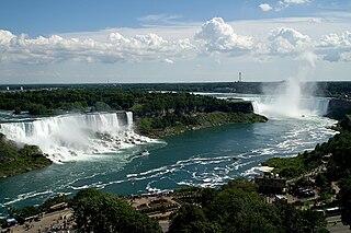
Niagara Falls is a group of three waterfalls at the southern end of Niagara Gorge, spanning the border between the province of Ontario in Canada and the state of New York in the United States. The largest of the three is Horseshoe Falls, which straddles the international border of the two countries. It is also known as the Canadian Falls. The smaller American Falls and Bridal Veil Falls lie within the United States. Bridal Veil Falls is separated from Horseshoe Falls by Goat Island and from American Falls by Luna Island, with both islands situated in New York.

Lake Missoula was a prehistoric proglacial lake in western Montana that existed periodically at the end of the last ice age between 15,000 and 13,000 years ago. The lake measured about 7,770 square kilometres (3,000 sq mi) and contained about 2,100 cubic kilometres (500 cu mi) of water, half the volume of Lake Michigan.

The Oak Ridges Moraine is an ecologically important geological landform in the Mixedwood Plains of south-central Ontario, Canada. The moraine covers a geographic area of 1,900 square kilometres (730 sq mi) between Caledon and Rice Lake, near Peterborough. One of the most significant landforms in southern Ontario, the moraine gets its name from the rolling hills and river valleys extending 160 km (99 mi) east from the Niagara Escarpment to Rice Lake, formed 12,000 years ago by advancing and retreating glaciers during the last glaciation period. Below the approximately 200 metre thick glacial derived sediments of the moraine lies thick bedrock successions of Precambrian rocks and up to 200 metres of Ordovician aged rock, capped by a regional unconformity of erosion and non-deposition to the Quaternary period. Rivers and lakes scatter the landscape and are important for creating habitat for the rich diversity of species of animals, trees and shrubbery. These are also the supply of fresh water to aquifers in the moraine through complex subterranean connections. Construction development nearby, and with expansion of communities around the moraine in need of potable water, it is a contested site in Ontario, since it stands in the path of major urban development. Conservation of the moraine is thus an important step for keeping aquifers in a safe drinkable condition while also protecting the natural ecosystems surrounding and within the moraine. This region has been subject to multiple decades of scientific research to study the origins of formation, and how early communities used the land. A larger focus currently is how to source potable water without removing the aquifer entirely.

Glacial Lake Iroquois was a prehistoric proglacial lake that existed at the end of the last ice age approximately 13,000 years ago. The lake was essentially an enlargement of the present Lake Ontario that formed because the St. Lawrence River downstream from the lake was blocked by the ice sheet near the present Thousand Islands. The level of the lake was approximately 30 m (~100 ft) above the present level of Lake Ontario.

The Niagara Cantilever Bridge or Michigan Central Railway Cantilever Bridge was a cantilever bridge across the Niagara Gorge. An international railway-only bridge between Canada and the United States, it connected Niagara Falls, New York, and Niagara Falls, Ontario, located just south of the Whirlpool Bridge, and opened to traffic in 1883, it was replaced by the Michigan Central Railway Steel Arch Bridge in 1925.

Niagara Gorge is an 11 km (6.8 mi) long canyon carved by the Niagara River along the Canada–United States border, between the U.S. state of New York and the Canadian province of Ontario. It begins at the base of Niagara Falls and ends downriver at the edge of the geological formation known as the Niagara Escarpment near Queenston, Ontario, where the falls originated about 12,500 years ago. The position of the falls has receded upstream toward Lake Erie because of the falling waters' slow erosion of the riverbed's hard Lockport dolomite, combined with rapid erosion of the relatively soft layers beneath it. This erosion has created the gorge.


The Michigan Central Railway Bridge is an out-of-service steel Deck arch bridge spanning the Niagara Gorge between Niagara Falls, Ontario and Niagara Falls, New York. The bridge is owned by Canadian Pacific Kansas City, which purchased the single track structure in 1990. The Canadian corridor and bridge are owned by the City of Niagara Falls, Ontario. The bridge is located just upstream from the older arch-style Whirlpool Rapids Bridge used by Maple Leaf Amtrak passenger trains.

A tunnel valley is a U-shaped valley originally cut under the glacial ice near the margin of continental ice sheets such as that now covering Antarctica and formerly covering portions of all continents during past glacial ages. They can be as long as 100 km (62 mi), 4 km (2.5 mi) wide, and 400 m (1,300 ft) deep.

The Niagara Gorge Railroad was an interurban railway which ran at the bottom of the Niagara Gorge from Niagara Falls, New York to Lewiston, New York.

Sir Adam Beck Hydroelectric Generating Stations are two hydroelectric generating stations in Niagara Falls, Ontario, Canada. Sir Adam Beck Generating Station I, Sir Adam Beck Generating Station II and the Sir Adam Beck Pump Generating Station are all owned by Ontario Power Generation. Following the development of several smaller generating stations around Niagara Falls in the late 19th and early 20th centuries, the Province of Ontario authorized the construction of the first major publicly owned generating station in the province. At the time it was built, it was the largest hydroelectric generating station in the world.

The Robert Moses Niagara Hydroelectric Power Station is a hydroelectric power station in Lewiston, New York, near Niagara Falls. Owned and operated by the New York Power Authority (NYPA), the plant diverts water from the Niagara River above Niagara Falls and returns the water into the lower portion of the river near Lake Ontario. It uses 13 generators at an installed capacity of 2,525 MW (3,386,000 hp).
The Niagara Tunnel Project was part of a series of major additions to the Sir Adam Beck hydroelectric generation complex in Niagara Falls, Ontario, Canada.
Minneapolis is the largest city in the state of Minnesota in the United States, and the county seat of Hennepin County.
The River Warren Falls was a massive waterfall on the glacial River Warren initially located in present-day Saint Paul, Minnesota, United States. The waterfall was 2700 feet (823 m) across and 175 feet (53 m) high.
The Great Lakes-St. Lawrence Lowlands, or simply St. Lawrence Lowlands, is a physiographic region of Eastern Canada that comprises a section of southern Ontario bounded on the north by the Canadian Shield and by 3 of the Great Lakes — Lake Huron, Lake Erie and Lake Ontario — and extends along the St. Lawrence River to the Strait of Belle Isle and the Atlantic Ocean. The lowlands comprise three sub-regions that were created by intrusions from adjacent physiographic regions — the West Lowland, Central Lowland and East Lowland. The West Lowland includes the Niagara Escarpment, extending from the Niagara River to the Bruce Peninsula and Manitoulin Island. The Central Lowland stretches between the Ottawa River and the St. Lawrence River. The East Lowland includes Anticosti Island, Îles de Mingan, and extends to the Strait of Belle Isle.

The Niagara Whirlpool is a natural whirlpool within the Niagara River located along the Canada–U.S. border between New York and Ontario. The whirlpool is in the Niagara Gorge, downstream from Niagara Falls. The whirlpool's greatest depth is 125 feet (38 m).
The Beck tunnel boring machine was the largest tunnel boring machine in the world, when it was operated by Ontario Power Generation, from 2006 to 2011. Hydro used it to bore a deep replacement tunnel to supply water from the upper Niagara River 10.2 kilometres (6.3 mi) to the Sir Adam Beck Hydroelectric Plant. The tunnel it bored was 14.4 metres (47 ft) in diameter.
References
- ↑ "Niagara Falls Origins - a Geological History". Niagarafrontier.com. 2011-06-23. Retrieved 2011-08-21.
- 1 2 3 "Niagara Falls Geological History | The St. David's Buried Gorge - Niagara Falls, Ontario, Canada". Niagarafallsinfo.com. Retrieved 2011-08-21.
- 1 2 "Niagara Whirlpool (FAQ)". Nyfalls.com. Retrieved 2011-08-20.
- ↑ Ray Spiteri (2013-03-22). "More water, more power: Tunnel in service". Niagara Falls Review . Retrieved 2016-01-28.
The tunnels ran only as far as St. David's Buried Gorge, an ancient river valley that crosses the modern Niagara River a few kilometres below the Falls. Since the loose silt filling the gorge couldn't be safely tunnelled through, the tunnels have to veer back up to the surface and the water completes its journey in a canal. The Americans, meanwhile, were also building tunnels to feed a new power plant across the river from the Beck stations, using the even more disruptive cut-and-cover technique, essentially digging a giant trench then covering it.