External links
| | This Russian military article is a stub. You can help Wikipedia by expanding it. |
| | This article relating to artillery is a stub. You can help Wikipedia by expanding it. |
The Sakar-20 is a Russian-made 122mm surface-to-surface missile. It is approximately 2 meters in length with a range of approximately 30 kilometers and the capacity to devastate an area of about 100 square meters. There are reports[ citation needed ] of Pakistani-supplied Sakar-20s being used by the Taliban against United States military, NATO and Afghan positions along the border with Pakistan.
| | This Russian military article is a stub. You can help Wikipedia by expanding it. |
| | This article relating to artillery is a stub. You can help Wikipedia by expanding it. |

Afghanistan is a landlocked mountainous country located at the crossroads of Central and South Asia. It is also sometimes included as part of the Middle East. The country is the 40th largest in the world in size. Kabul is the capital and largest city of Afghanistan, located in the Kabul Province. With a location at the intersection of major trade routes, Afghanistan has attracted a succession of invaders since the sixth century BCE.

The Durand Line, forms the Afghanistan–Pakistan border, a 2,670-kilometre (1,660 mi) international land border between the countries of Afghanistan and Pakistan in South Asia. The western end runs to the border with Iran and the eastern end to the border with China.

The Buddhas of Bamiyan were two 6th-century monumental statues carved into the side of a cliff in the Bamyan valley of central Afghanistan, 130 kilometres (81 mi) northwest of Kabul at an elevation of 2,500 metres (8,200 ft). Carbon dating of the structural components of the Buddhas has determined that the smaller 38 m (125 ft) "Eastern Buddha" was built around 570 AD, and the larger 55 m (180 ft) "Western Buddha" was built around 618 AD, which would date both to the time when the Hephthalites ruled the region.

Chitral District was the largest district in the Khyber-Pakhtunkhwa province of Pakistan, covering an area of 14,850 km², before splitting into Upper Chitral District and Lower Chitral District in 2018. Part of the Malakand Division, it is the northernmost district of Pakistan. It shares a border with Gilgit-Baltistan to the east, with Kunar, Badakshan and Nuristan provinces of Afghanistan to the north and west, and with the Khyber-Pakhtunkhwa districts of Swat and Dir to the south. A narrow strip of Wakhan Corridor separates Chitral from Tajikistan in the north.

The slaty-headed parakeet is the only psittacid species to exhibit altitudinal migration. The species' range extends from Pakistan, to Western Himalayas in India through Nepal and Bhutan and up to the Eastern Himalayas in the northeastern Indian state of Arunachal Pradesh. They descend to the valleys in winter, approximately during the last week of October.
The Afghan hedgehog(Hemiechinus auritus megalotis) is a subspecies of the long-eared hedgehog native to Afghanistan and western Pakistan. It is larger and reddish in colour, but otherwise similar in appearance to the long-eared hedgehog.

Jurm District is one of the 28 districts of Badakhshan Province in northeast Afghanistan. The district capital is a town named Jurm. The district is 3 hours from the center of the province in Fayzabad, and is home to approximately 41,910 residents. The highest point of the Afghan Hindu Kush is located in Jurm District, at 6729 meters. The district consist of clusters and villages. Ferghamenj, Kyb, Kyteb, Ularyb, Ferghameru, Khustak, and Iskan are the clusters. Each cluster contain villages; the district is largely Tajik speaking.

Elhovo is a Bulgarian town in Yambol Province, located on the left bank of the Tundzha river, between Strandzha and Sakar mountains. Second largest city in the region after Jambol, the city is located at 36 km from border checkpoint Lesovo – Hamzabeyli on the Bulgarian – Turkish border. Elhovo is the administrative center of Elhovo municipality, which includes 21 villages (municipalities). The city's population to December 15, 2014, is 10 424 inhabitants.
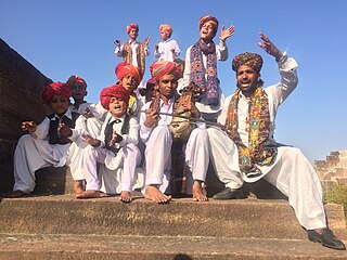
The Manganhar are a Muslim community found in the desert of Rajasthan, India; mostly in the districts of Barmer and Jaisalmer. also found in the districts of Tharparkar and Sanghar in the bordering province of Sindh in Pakistan. They along with the, Langha community, are known for their folk music. They are the groups of hereditary professional musicians, whose music has been supported by wealthy landlords and aristocrats for generations.
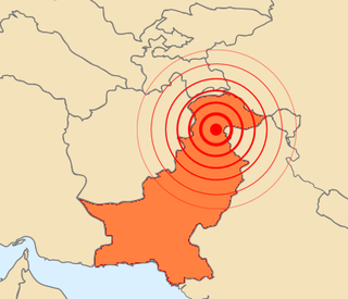
The 2005 Kashmir earthquake occurred at 08:50:39 Pakistan Standard Time on 8 October in Pakistani-administered Azad Kashmir. It was centred near the city of Muzaffarabad, and also affected nearby Balakot in Khyber Pakhtunkhwa and some areas of Indian-administered Jammu and Kashmir. It registered a moment magnitude of 7.6 and had a maximum Mercalli intensity of XI (Extreme). The earthquake was also felt in Afghanistan, Tajikistan, India and the Xinjiang region. The severity of the damage caused by the earthquake is attributed to severe upthrust. Over 86,000 people died, a similar number were injured, and millions were displaced. It is considered the deadliest earthquake in South Asia, surpassing the 1935 Quetta earthquake.
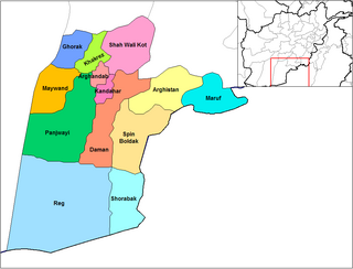
The Arghistan District is a district in the northeastern part of Kandahar Province, Afghanistan. It borders Spin Boldak District to the south and west, Daman District to the west, Zabul Province to the north, Maruf District to the east and Pakistan to the east and south. The population is 30,500 (2006). The district's center is the village of Arghistan, in the physical center of the district in the Arghistan River valley.
Spera District is situated in the most southwestern part of Khost Province, Afghanistan. It borders with Paktia Province to the south and west, Shamal District to the north. The district is within the heartland of the Zadran tribe of Pashtuns. To the east it borders Nadir Shah Kot and Tani districts and Pakistan. The population is 21,500 people. The district center is the village of Spera, situated in the central part of the district.
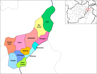
Dangam District is situated in the eastern end of Kunar Province in Afghanistan. It borders Marawara district to the southwest, Asadabad district to the west, Bar Kunar district to the north, Nari district to the northeast and Khyber Pakhtunkhwa in Pakistan to the east. The district is mountainous and stunning but also poor.
Chabahar Port is a seaport in Chabahar located in southeastern Iran, on the Gulf of Oman. It serves as Iran's only oceanic port, and consists of two separate ports named Shahid Kalantari and Shahid Beheshti, each of which has five berths. It is only about 170 kilometres west of the Pakistani port of Gwadar.
The Chaman Fault is a major, active geological fault in Pakistan and Afghanistan that runs for over 850 km. Tectonically, it is actually a system of related geologic faults that separates the Eurasian Plate from the Indo-Australian Plate. It is a terrestrial, primarily transform, left-lateral strike-slip fault. The slippage rate along the Chaman fault system as the Indo-Australian Plate moves northward has been estimated at 10 mm/yr or more. In addition to its primary transform aspect, the Chaman fault system has a compressional component as the Indian Plate is colliding with the Eurasian Plate. This type of plate boundary is sometimes called a transpressional boundary.

Energy in Afghanistan is provided by hydropower followed by fossil fuel and solar power. According to Da Afghanistan Breshna Sherkat (DABS), approximately 35% of Afghanistan's population has access to electricity. This covers the major cities in the country. Many rural areas do not have access to 24-hour electricity but this should change after the major CASA-1000 project is completed.
Chapursan is a valley containing approximately eight scattered villages situated within the Hunza District of Gilgit−Baltistan, Pakistan. It is located in the northernmost part of Pakistan and is close to the country's international borders with the Wakhan Corridor of Afghanistan and the Xinjiang Uyghur Autonomous Region of China. The valley is predominantly inhabited by ethnic Wakhis; the village of Raminj in this region is inhabited by ethnic Burushos. The valley's inhabitants largely adhere to the Isma'ili sect of Shia Islam. Chapurson hosts over 500 households with an estimated population of 3000 people.

On 16 December 2014, six gunmen affiliated with the Tehrik-i-Taliban Pakistan (TTP) conducted a terrorist attack on the Army Public School in the northwestern Pakistani city of Peshawar. The militants, all of whom were foreign nationals, comprising one Chechen, three Arabs and two Afghans, entered the school and opened fire on school staff and children, killing 149 people including 132 schoolchildren ranging between eight and eighteen years of age, making it the world's fourth deadliest school massacre. A rescue operation was launched by the Pakistan Army's Special Services Group (SSG) special forces, who killed all six terrorists and rescued 960 people.
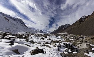
Sakar Sar is a mountain peak located at 6,272 metres above sea level. It lies in the Hindu Kush-Karakoram, in part in the Gilgit-Baltistan region of Pakistan-administered Kashmir and in part in Afghanistan's Wakhan Corridor.
The 1983 Hindu Kush earthquake occurred south of Fayzabad, Badakhshan in northeast Afghanistan, near the border with Pakistan and the USSR. Striking 214.5 km beneath the Hindu Kush mountains, the moment magnitude 7.4 quake affected three countries, killing at least 26 people and injuring several hundred.