
The Gaza Strip, or simply Gaza, is a polity and the smaller of the two Palestinian territories. On the eastern coast of the Mediterranean Sea, Gaza is bordered by Egypt on the southwest and Israel on the east and north.

The 84th "Givati" Brigade is an Israel Defense Forces infantry brigade formed in 1947.
This page is a partial listing of incidents of violence in the Israeli-Palestinian conflict in 2004.

The Gaza–Israel barrier is a border barrier located on the Israeli side of the Gaza–Israel border. Before the 2023-24 Israel-Hamas war, the Erez Crossing, in the north of the Gaza Strip, used to be the only crossing point for people and goods coming from Israel into the Gaza Strip, with a second crossing point, the Kerem Shalom border crossing, used exclusively for goods coming from Egypt, as Israel didn't allow goods to go directly from Egypt into Gaza through the Egypt–Gaza border, except for the Salah Al Din Gate, opened in 2018.

The Popular Resistance Committees is a coalition of a number of armed Palestinian groups opposed to what they regard as the conciliatory approach of the Palestinian Authority and Fatah towards Israel.
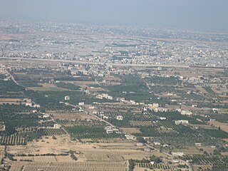
Rafah is a Palestinian city in the southern Gaza Strip. It is the capital of the Rafah Governorate of the State of Palestine, located 30 kilometers (19 mi) south-west of Gaza City. In 2017, Rafah had a population of 171,889. As a result of massive bombardment and ground assaults in Gaza City and Khan Yunis by Israel during the Israel–Hamas war, about 1.4 million people are believed to be sheltering in Rafah as of February 2024.

The Gaza Strip smuggling tunnels are smuggling tunnels that had been dug under the Philadelphi Route along the Egypt–Gaza border. They were dug to subvert the blockade of the Gaza Strip to smuggle in fuel, food, weapons and other goods into the Gaza Strip. After the Egypt–Israel peace treaty of 1979, the town of Rafah, in the southern Gaza Strip, was split by this buffer zone. One part is located in the southern part of Gaza, and the smaller part of the town is in Egypt. After Israel withdrew from Gaza in 2005, the Philadelphi Corridor was placed under the control of the Palestine Authority until 2007, when Hamas seized power in 2007, and Egypt and Israel closed borders with the Gaza Strip.

In 2004, the Israel Defense Forces (IDF) launched Operation Rainbow in the southern Gaza Strip on 12–24 May 2004, involving an invasion and siege of Rafah. The operation was started after the deaths of eleven Israeli soldiers in two Palestinian attacks, in which M113 armored vehicles were attacked.
The Izz ad-Din al-Qassam Brigades, named after Izz ad-Din al-Qassam, is the military wing of the Palestinian organization Hamas. Currently led by Mohammed Deif, IQB is the largest and best-equipped militant group operating within Gaza today.

This article describes transport in the State of Palestine, which consists of two non-contiguous territories, the West Bank and the Gaza Strip, different parts of which are administered by Palestinian National Authority, Hamas Administration in Gaza and Israel.
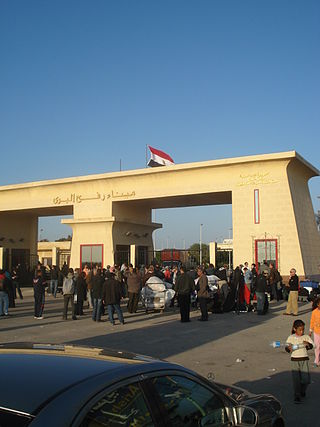
The Rafah Border Crossing or Rafah Crossing Point is the sole crossing point between Egypt and Palestine's Gaza Strip. It is located on the Egypt–Palestine border. Under a 2007 agreement between Egypt and Israel, Egypt controls the crossing but imports through the Rafah crossing require Israeli approval.
A blockade has been imposed on the movement of goods and people in and out of the Gaza Strip since Hamas's takeover in 2007, led by Israel and supported by Egypt. The blockade's current stated aim is to prevent the smuggling of weapons into Gaza; previously stated motivations have included exerting economic pressure on Hamas. Human rights groups have called the blockade illegal and a form of collective punishment, as it restricts the flow of essential goods, contributes to economic hardship, and limits Gazans' freedom of movement. The blockade and its effects have led to the territory being called an "open-air prison".

The Gaza War, also known as Operation Cast Lead, also known as the Gaza Massacre, and referred to as the Battle of al-Furqan by Hamas, was a three-week armed conflict between Gaza Strip Palestinian paramilitary groups and the Israel Defense Forces (IDF) that began on 27 December 2008 and ended on 18 January 2009 with a unilateral ceasefire. The conflict resulted in 1,166–1,417 Palestinian and 13 Israeli deaths. Over 46,000 homes were destroyed in Gaza, making more than 100,000 people homeless.

Egypt–Palestine relations are the bilateral relations between the Arab Republic of Egypt and the State of Palestine. Egyptian President Gamal Abdel Nasser was a strong supporter of the Palestinian cause and he favored self-determination for the Palestinians. Although the Egyptian government has maintained a good relationship with Israel since the Camp David Accords, most Egyptians strongly resent Israel, and disapprove of the close relationship between the Israeli and Egyptian governments.

Kerem Shalom border crossing is a border crossing at the junction of two border sections: one between the Gaza Strip and Israel, and one between the Gaza Strip and Egypt. It is used by trucks carrying goods from Israel or Egypt to the Gaza Strip.

The Egypt–Palestine border, also called Egypt–Gaza border, is the 12-kilometre (7.5 mi) long border between Egypt and the Gaza Strip. There is a buffer zone along the border which is about 14 kilometres (8.7 mi) long.

A vast network of tunnels used for smuggling and warfare purposes exists under the Gaza Strip. The underground tunnel network allows Hamas and other militant groups to store and shield weapons, gather and move underground, communicate, train, launch offensive attacks, transport hostages, and retreat without being detected by Israeli or Egyptian authorities. This network of tunnels is colloquially referred to as the Gaza metro. According to General Hassan Hassanzadeh, the commander of the Islamic Revolutionary Guard Corps (IRGC) forces in Tehran, there are more than 500 kilometers of tunnels.
The year 2023 in Israel was defined first by wide-scale protests against a proposed judicial reform, and then by the Hamas-led attack on Israel on October 7, which led to a war and to Israel invading the Gaza Strip.
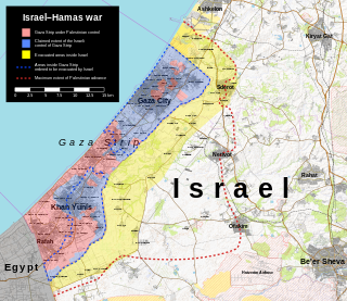
On 27 October 2023, Israel launched an invasion of the Gaza Strip with the stated goals to destroy Hamas, a military and political movement that led an attack on Israel earlier in the month, and to free hostages it took. The effort is ongoing. Before the invasion, dubbed Operation Swords of Iron, Israel declared war, tightened its blockade, and ordered the evacuation of the northern Gaza Strip.
During the Israel–Hamas war, the Israeli military ordered most residents of Gaza to evacuate their homes, displacing hundreds of thousands of people and contributing to a broader humanitarian crisis in the territory. It is the largest displacement of Palestinians in 75 years. Palestinians have described the evacuation as the "second Nakba."
