The Gulf of Saint Lawrence is the outlet of the North American Great Lakes via the Saint Lawrence River into the Atlantic Ocean. The gulf is a semienclosed sea, covering an area of about 226,000 square kilometres (87,000 sq mi) and containing about 34,500 cubic kilometres (8,300 cu mi) of water, which results in an average depth of 152 metres (499 ft).

The Arctic Archipelago, also known as the Canadian Arctic Archipelago, is a group of islands north of the Canadian mainland.

Portas is a municipality in Galicia, Spain in the province of Pontevedra.
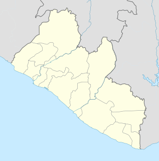
Pleebo is a city located in Maryland County, Liberia. It is the largest city in Maryland County with a population of 22,693 in 2008.
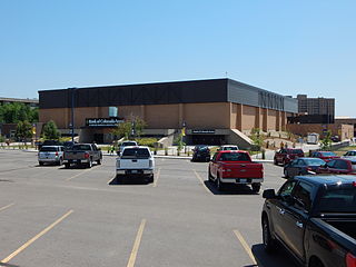
Bank of Colorado Arena at Butler-Hancock Athletic Center is a 2,992-seat multi-purpose arena in Greeley, Colorado, United States. It was built in 1974 and is home to the University of Northern Colorado Bears men's and women's basketball teams, as well as the Bears volleyball, wrestling and indoor track and field programs.

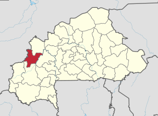
Boulsa is the capital of Namentenga Province in Burkina Faso. It is predominantly Mossi with small populations of Fula and Gulmanche peoples.

Remolino is a town and municipality of the Colombian Department of Magdalena. Founded between 1752 and 1776 by Fernando de Mier y Guerra. Erected municipality in 1814.

Bochalema is a Colombian municipality and town located in the department of North Santander.

Camponaraya is a village and municipality located in the region of El Bierzo. According to the 2010 census (INE), the municipality has a population of 4,230 inhabitants.
Donsin is a village in the Bissiga Department of Boulgou Province in south-eastern Burkina Faso. As of 2005, the village has a population of 557.
Dəstor is a village in the municipality of Asxanakəran in the Astara Rayon of Azerbaijan.
Baumann Fiord is a natural inlet in the south-west of Ellesmere Island, Nunavut in the Canadian Arctic Archipelago. To the west, it opens into Norwegian Bay. Hoved Island lies in the fiord.
Papaqçılar is a village and municipality in the Tovuz Rayon of Azerbaijan. It has a population of 1,387. The municipality consists of the villages of Papaqçılar and Güvəndik.
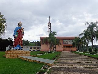
São José do Cerrito is a municipality in the state of Santa Catarina in the South region of Brazil.

Piikani 147, formerly Peigan 147, is an Indian reserve in Alberta. It is located 61 kilometres (38 mi) west of the City of Lethbridge. It has a land area of 430.31 km², making it the fourth-largest Indian reserve in Canada, and lies at an elevation of 1,046 metres (3,432 ft). The Canada 2011 Census reported a population of 1,217 inhabitants. It is bordered by the Municipal District of Willow Creek No. 26 on its north and east, and by the Municipal District of Pincher Creek No. 9 on its west and south. The nearest outside communities are Fort Macleod and Pincher Creek.
Kalâat Khasba is a town and commune in the Kef Governorate, Tunisia. As of 2004 it had a population of 2,871.and is the chief town of a delegation of 7,353 people.

Béoumi Department is a department of Gbêkê Region in Vallée du Bandama District, Ivory Coast. In 2014, its population was 154,206 and its seat is the settlement of Béoumi. The sub-prefectures of the department are Ando-Kékrénou, Béoumi, Bodokro, Kondrobo, Lolobo, Marabadiassa, and N'Guessankro. It is the geographical center of the country.

Kələman is a village in the Gadabay Rayon of Azerbaijan. The village forms part of the municipality of Poladlı.

German submarine U-173 was a Type IXC U-boat of Nazi Germany's Kriegsmarine during World War II.
Nanticoke Wildlife Area is a state wildlife area located in Sussex County, Delaware, along the Nanticoke River and Broad Creek, near to Seaford, Delaware, and Bethel, Delaware. There is a monument commenmorating Captain John Smith's journey into the Chesapeake Bay and its tributaries at Phillips Landing along Broad Creek, a tributary of the Nanticoke River in Delaware. It is made up of three large land tracts totaling 4,510 acres (1,825 ha), it is managed by Delaware Department of Natural Resources and Environmental Control (DNREC), Division of Fish and Wildlife.