Related Research Articles

Europa Point, is the southernmost point of Gibraltar. Although not the southernmost point of the Iberian Peninsula, Europa Point defines the boundary between the Straits of Gibraltar in the Atlantic Ocean, and the Alboran Sea within the Mediterranean. At the end of the Rock of Gibraltar, the area is flat and occupied by such features as a playing field and a few buildings. On a clear day, views of North Africa can be seen across the Strait of Gibraltar including Ceuta and the Rif Mountains of Morocco; as well as the Bay of Gibraltar and the Spanish towns along its shores. It is reached from the old town by Europa Road.

The Gibraltar territory currently contains an 800-metre (2,625 ft) long section of the isthmus that links the Rock with mainland Spain. Spain does not acknowledge British sovereignty over Gibraltar beyond the fortified perimeter of the town as at 1704. The United Kingdom claims the southern part of the isthmus on the basis of continuous possession over a long period.

Originally from the Atlas Mountains and the Rif Mountains of Morocco, the Barbary macaque population in Gibraltar is the only wild monkey population on the European continent. Although most Barbary monkey populations in Africa are experiencing decline due to hunting and deforestation, the Gibraltar population is increasing. As of 2020, some 300 animals in five troops occupy the Upper Rock area of the Gibraltar Nature Reserve, though they make occasional forays into the town. As they are a tailless species, they are also known locally as Barbary apes or rock apes, despite being classified as monkeys. Spanish speakers simply refer to them as monos when conversing in Spanish, although English is the native language as the area is a British overseas territory.

Gibraltar National Day, celebrated annually on 10 September, is the official national day of the British overseas territory of Gibraltar. The day commemorates Gibraltar's first sovereignty referendum of 1967, in which Gibraltarian voters were asked whether they wished to either pass under Spanish sovereignty, or remain under British sovereignty, with institutions of self-government.

Panorama is a daily newspaper published in Gibraltar.

Simón Rodríguez Susarte, commonly known as Simón Susarte, was a Spanish goatherd from Gibraltar, who in 1704 aided a Bourbon Spanish attempt to seize Gibraltar during the Twelfth Siege of Gibraltar by revealing a concealed path to the attackers which led to the top of the Rock of Gibraltar. Susarte then guided a Bourbon contingent along this difficult trail, aiming to surprise the Grand Alliance garrison in hopes of recovering the town.
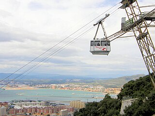
Gibraltar Cable Car is an aerial tramway in Gibraltar. The base station of the cable car is located near the southern end of Main Street, next to Alameda Gardens.

The South Mole is a breakwater located in the southern section of Gibraltar Harbour, in the British Overseas Territory of Gibraltar, at the southern end of the Iberian Peninsula. Previously known as the New Mole and New Mole Extension, the South Mole, with the rest of harbour, is just north of the east entrance to the Strait of Gibraltar.

The Gibraltar–Spain border is the international boundary between the British Overseas Territory of Gibraltar and the Kingdom of Spain. It is also referred to as "The Fence of Gibraltar" or simply "The Fence".

Playa de El Chinarral is a beach in the municipality of Algeciras, southeastern Spain. It overlooks the Bay of Algeciras and the tip of the rock of Gibraltar. It is approximately 250 metres in length and 40 metres wide on average. It is located between Punta de San Garcia and El Rodeo, south of the city.

Fuerte de San García was a fort in Algeciras, Spain, It was built in the 1730s and destroyed in 1811 to deny it to the French. Today all that remains are the foundation and base ruins, in the Parque del Centenario, but it is a registered Bien de Interés Cultural landmark

Wellington Front is a fortification in the British Overseas Territory of Gibraltar. It was built in 1840 on a site established by the Spanish in 1618.

Jumper's Bastion may refer to one of two adjacent bastions in the British Overseas Territory of Gibraltar. They were both created in 1785 on the sites of previous constructions and named for a British Captain who was one on the first on shore during the Capture of Gibraltar in 1704.
The Christian Brothers School was a school in the British Overseas Territory of Gibraltar. The school was a technical school in the 1930s and in 1950 became the Gibraltar Grammar School until comprehensive education was introduced in the 1970s. The building was then home to the Sacred Heart Middle School but was no longer run by the Congregation of Christian Brothers. In July 2015, the Sacred Heart Middle School became the Saint Bernard's Middle School and moved to a different location. The building was renovated and now houses Prior Park School, Gibraltar's first co-educational, Catholic independent secondary school. Prior Park School is the fourth school in the Prior Park family, the other three being located in Bath and Wiltshire, UK.

The Gibraltar peninsula, located at the far southern end of Iberia, has great strategic importance as a result of its position by the Strait of Gibraltar where the Mediterranean Sea meets the Atlantic Ocean. It has repeatedly been contested between European and North African powers and has endured fourteen sieges since it was first settled in the 11th century. The peninsula's occupants – Moors, Spanish, and British – have built successive layers of fortifications and defences including walls, bastions, casemates, gun batteries, magazines, tunnels and galleries. At their peak in 1865, the fortifications housed around 681 guns mounted in 110 batteries and positions, guarding all land and sea approaches to Gibraltar. The fortifications continued to be in military use until as late as the 1970s and by the time tunnelling ceased in the late 1960s, over 34 miles (55 km) of galleries had been dug in an area of only 2.6 square miles (6.7 km2).

The Great North Road is a large road tunnel in the British Overseas Territory of Gibraltar. It was constructed by the British military during World War II inside the Rock of Gibraltar and remains property of the Ministry of Defence to this day. The road allowed lorries to travel from the north to the south of Gibraltar entirely within the Rock. The tunnel still contains the remains of World War II buildings such as Nissen huts, kitchens, offices as well as a generating station and period anti-submarine nets.

The Prince of Wales Lines were a set of earthworks constructed in Gibraltar in 1756 on the orders of Lord Tyrawley, during his term as Governor of Gibraltar. They consisted of a series of retrenchments for guns and muskets constructed between the glacis of the South Front to the New Mole, south of Gibraltar's urban area.
Ragged Staff Flank is a masonry fortification on the South Front of Gibraltar's fortifications. It continues the line of the South Bastion's seaward face across the South Front ditch, then turns to form a flanking position facing south along the coastal fortifications leading to the New Mole. The Ragged Staff Gates were situated in the middle of the flank, leading to the Ordnance Wharf that was located where the Dockyard North Gate used to stand. A defended enclosure stood behind the gate, secured by the Ragged Staff Guardhouse. The flank position had three embrasures in its parapet but only mounted two 24-pdr guns in 1779, though these were replaced by 32-pdrs under the rearmament plan of 1859.

Prince Albert's Front is a curtain wall that formerly comprised part of the seafront fortifications of Gibraltar. It runs between the King's Bastion and Orange Bastion. The Front was constructed in 1842 after a report by Major General Sir John Thomas Jones recommended improving Gibraltar's seafront defences to guard against the threat of an amphibious assault. It was named after Prince Albert, Queen Victoria's prince consort. The Front straightened out the line of Gibraltar's coastal curtain wall; parts of the original curtain wall, some of which dates from the Moorish period over 500 years ago, can still be seen.

Mediterranean Steps is a path and nature trail in the British Overseas Territory of Gibraltar. One of the footpaths of Gibraltar, the path is located entirely within the Upper Rock Nature Reserve and was built by the British military but is now used by civilians as a pedestrian route linking Martin's Path to Lord Airey's Battery near the summit of Rock of Gibraltar. The path offers views over the Strait of Gibraltar, Windmill Hill, Europa Point, the Great Sand Dune, Gibraltar's east side beaches, the Mediterranean Sea and the Spanish Costa del Sol.