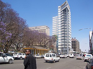
Harare, formerly Salisbury, is the capital and largest city of Zimbabwe. The city proper has an area of 982.3 km2 (379.3 sq mi), a population of 1,849,600 as of the 2022 census and an estimated 2,487,209 people in its metropolitan province. The city is situated in north-eastern Zimbabwe in the country's Mashonaland region. Harare is a metropolitan province which also incorporates the municipalities of Chitungwiza and Epworth. The city sits on a plateau at an elevation of 1,483 metres above sea level, and its climate falls into the subtropical highland category.

Mabvuku is a suburb east of Harare, the capital city of Zimbabwe.

Chitungwiza is the third populous urban centre in Zimbabwe and town of Harare Province in Zimbabwe. It is located on the outskirts of Harare.

The National Sports Stadium is a multi-purpose stadium, in Harare, Zimbabwe, with a maximum capacity of 60,000 people. It is the largest stadium in Zimbabwe, located in Harare, just a Few meters from Heroes Acre. It is used mostly for football matches, but is also used for rugby union. Association football club CAPS United F.C. use the venue, which opened in 1987, for most of their home games.
Norton is a commuter town and suburb of Harare in the province of Mashonaland West, Zimbabwe. It is located about 40 km west of Harare on the main road and railway line connecting Harare and Bulawayo.
Gateway High School is a Christian, co-educational, independent school in Emerald Hill, Harare, Zimbabwe. It has 700 students from Form 1 to Upper 6. The school had its first form 1 intake in 1991 and the first upper 6 class graduated in 1995 under the headship of Paul Revell, along with Marcus Chibisa and Ron Montague as his deputies. The school is located on Sam Nujoma Street.
Waterfalls is a residential suburb in the southern region of Harare, Zimbabwe and falls under Harare Ward 23 District. Waterfalls neighbourhoods include Ardbennie, Cheviot, Derbyshire, Grobbie Park, Houghton Park, Induna Park, Mainway Meadows, Malvern, Midlands, Parktown, Prospect, Shortstone and Uplands. The name Waterfalls is a reference to the falls that lead into Mukuvisi River. There are squatted informal settlements around Waterfalls. As of 2013, the biggest squatter zone in Harare was Hopley, next to Waterfalls.

The A2 Highway is a primary road in Zimbabwe running from Harare to Nyamapanda at the border with Mozambique. The Mozambican side border post is called Cochemane. This is a busy entry point used by people travelling by road between South Africa, Malawi, Zimbabwe and Mozambique. It starts at intersection with Samora Machel Avenue; however Enterprise Road itself begins from the T-junction with Robert Mugabe Avenue, opposite the market in Eastlea, east of Simon Muzenda Street Road Port; a bus terminus for inter-regional buses.
Kuwadzana is a residential suburb in Harare, Zimbabwe. It was originally known as Parkridge Fontainebleau. It lies on the city's western border, just south of the main Harare-Bulawayo road. In the 1980s, Kuwadzana was selected for slum upgrading on the site and services model. As of 2012, the population was 26,926.
Alexandra Park is an affluent, leafy residential suburb in the north of Harare, Zimbabwe. The area was developed for White former servicemen and their families in the post-war years following the Second World War.
Nedbank Zimbabwe Limited, also Nedbank Zimbabwe, is a commercial bank in Zimbabwe. It is licensed by the Reserve Bank of Zimbabwe, the central bank and national banking regulator. The bank was previously known as MBCA Bank, prior to rebranding to its present name.
Standard Chartered Zimbabwe is a commercial bank in Zimbabwe and a subsidiary of FBC Holdings since 2024. It is licensed by the Reserve Bank of Zimbabwe, the central bank and national banking regulator.
Steward Bank, whose official name is Steward Bank Limited, is a commercial bank in Zimbabwe. It is one of the regulated banking institutions licensed by the Reserve Bank of Zimbabwe, the central bank and national banking regulator.
Allied Bank, was a commercial bank in Zimbabwe that closed in 2015. The bank regulator cancelled its license on 8 January 2015 after determining that the bank was "no longer in a safe and sound condition, grossly undercapitalised and facing chronic liquidity challenges"
The A5 Highway is a national road in Zimbabwe. It joins the cities of Harare and Bulawayo, and is hence known as the Harare-Bulawayo Highway. It is one of the two routes that form the R2 Route, which connects Harare with the Plumtree Border with Botswana.
The R3 highway is a primary road in Zimbabwe that runs from the capital city, Harare, to the Chirundu Border Post with Zambia. It is also known as the A1 highway. It is part of both the Beira–Lobito Highway and the Cape to Cairo Road.
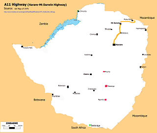
A11 Highway is a national road in Zimbabwe, running from Harare to Bindura through to Mount Darwin. It is also known as the P1 Road, Zimbabwe primary road number 1.

The Cathedral of St Mary and All Saints, Harare is an Anglican cathedral in Zimbabwe. The cathedral, located at the intersection of Nelson Mandela Avenue and Sam Nujoma Street in Harare, was begun in 1913 to plans by British architect Herbert Baker; he also designed the cathedrals of Cape Town and Johannesburg.
Glen Lorne is an affluent neighbourhood in northeast Harare, Zimbabwe. It was originally known as Glen Lorne farm or Enterprise valley, beyond the city limits. It is located north of downtown Harare and is one of highest and hilliest suburbs. It is also one of the wealthiest and most prestigious neighbourhoods in Zimbabwe. Glen Lorne has been ranked the best neighbourhood in the city to live in by the Mail & Guardian. It is known as the area where the city's 'old money' lives, and is home to some of Zimbabwe's wealthiest citizens including former vice president, Kembo Mohadi. It is often compared to its larger and more well-known neighbour, Borrowdale to the northwest.