The Arctic Archipelago, also known as the Canadian Arctic Archipelago, is an archipelago lying to the north of the Canadian continental mainland, excluding Greenland and Iceland.
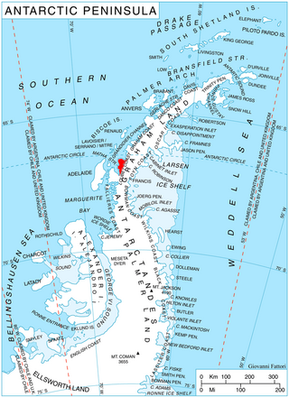
The Scaife Mountains is a group of mountains rising west of Prehn Peninsula and between the Ketchum Glacier and Ueda Glacier, at the base of the Antarctic Peninsula.

Sur Lípez or Sud Lípez is a province in the Potosí Department in Bolivia. The seat of the province is San Pablo de Lípez.
Northeast Glacier is a steep, heavily crevassed glacier, 13 nautical miles long and 5 nautical miles wide at its mouth, which flows from McLeod Hill westward and then south-westwards into Marguerite Bay between the Debenham Islands and Roman Four Promontory, on the west coast of Graham Land, Antarctica.
Rymill Bay is a bay, 9 nautical miles wide at its mouth and indenting 5 nautical miles between Red Rock Ridge and Bertrand Ice Piedmont along the west coast of Graham Land, Antarctica.

Sheldon Glacier is a glacier flowing southeast from Mount Mangin into Ryder Bay, Adelaide Island, Antarctica. Named by the United Kingdom Antarctic Place-Names Committee (UK-APC) in 1977 for Ernest B. Sheldon, British Antarctic Survey (BAS) meteorological observer, Adelaide Station, 1968–69, and Stonington Island, 1969–70; Base Commander, Adelaide Station, 1975–76, and Rothera Station, 1976–77.
The Mariner Glacier is a major glacier over 60 nautical miles long, descending southeast from the plateau of Victoria Land, Antarctica, between Mountaineer Range and Malta Plateau, and terminating at Lady Newnes Bay, Ross Sea, where it forms the floating Mariner Glacier Tongue.

Haefeli Glacier is a glacier, 2 miles (3 km) wide and 6 miles (10 km) long, situated on Pernik Peninsula, Loubet Coast in Graham Land, Antarctica, at the northwest side of Finsterwalder Glacier and flowing south-southwest toward the head of Lallemand Fjord. With Finsterwalder and Klebelsberg Glaciers, its mouth merges with Sharp Glacier where the latter enters the fjord. It was first surveyed in 1946–47 by the Falkland Islands Dependencies Survey and named by them for Robert Haefeli, a Swiss glaciologist.
Ajax Icefall' is an icefall between Stenhouse Bluff and Ullmann Spur at the head of Visca Anchorage, King George Island, in the South Shetland Islands. Charted by the French Antarctic Expedition under Jean-Baptiste Charcot in 1908–10. Named by the United Kingdom Antarctic Place-Names Committee in 1960 for HMS Ajax, which assisted in the search for a boat crew from the Discovery II, missing on King George Island in January 1937.
Djeol is a town and commune in Mauritania, near the border of Senegal.
Suriyaco is a municipality and village in La Rioja Province in northwestern Argentina.
The Dorsey Mountains are a mountain range just east of Somigliana Glacier in the northern part of the Arrowsmith Peninsula in Graham Land. They were mapped by the Falkland Islands Dependencies Survey (FIDS) from surveys and air photos in 1956 to 1959 and named by the UK Antarctic Place-Names Committee (UK-APC) for Noah Ernest Dorsey, an American physicist.

Pelias Bluff is a conspicuous rock bluff rising to more than 150 meters at the head of the inlet lying immediately west of Standring Inlet, on the north coast of Jason Peninsula in Graham Land. It was surveyed by the Falkland Islands Dependencies Survey (FIDS) in 1953.

Klebelsberg Glacier is a glacier, 7 nautical miles (13 km) long and 2 nautical miles (4 km) wide, situated at the south side of Finsterwalder Glacier and flowing from Hemimont Plateau northwestward between Armula Peak and Smilyan Bastion on Graham Land, Antarctica, toward the head of Lallemand Fjord. With Finsterwalder Glacier and Haefeli Glacier, its mouth merges with Sharp Glacier where the latter enters the fjord. It was first surveyed from the plateau in 1946–47 by the Falkland Islands Dependencies Survey, and named by them for Raimund von Klebelsberg, an Austrian glaciologist.
McClary Glacier is a glacier 10 nautical miles (19 km) long and 2 nautical miles (4 km) wide on the west coast of Graham Land, Antarctica. It flows southwest along the north side of Butson Ridge into Marguerite Bay between Cape Calmette and the Debenham Islands. The glacier was first roughly surveyed by the British Graham Land Expedition, 1936–37, and resurveyed by the Falkland Islands Dependencies Survey, 1946–50. It was named by the UK Antarctic Place-Names Committee for George B. McClary, father of Nelson McClary, mate on the Port of Beaumont during the Ronne Antarctic Research Expedition, 1947–48.

Sölch Glacier is a glacier on the Pernik Peninsula of the Loubet Coast in Graham Land, flowing west to Salmon Cove just north of Kanchov Peak on the east side of Lallemand Fjord. It was mapped from air photos taken by the Falkland Islands and Dependencies Aerial Survey Expedition, 1956–57, and named by United Kingdom Antarctic Place-Names Committee for Johann Sölch (1883–1951), an Austrian glacial geologist and glaciologist.
League Rock is a distinctive rounded rock lying southwest of Box Reef, off the south end of Adelaide Island, Antarctica. It was surveyed by the Royal Navy Hydrographic Survey Unit, 1962–63, and was so named by the UK Antarctic Place-Names Committee because the rock lies one league distant from what was then Adelaide Station.
German submarine U-284 was a Type VIIC U-boat of Nazi Germany's Kriegsmarine during World War II.


