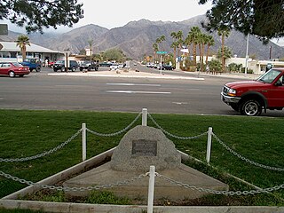
Borrego Springs is a census-designated place (CDP) in northeastern San Diego County, California. The population was 4,031 at the 2020 census, up from 3,429 at the 2010 census, and 2,535 at the 2000 census, including both seasonal and year-round residents. Borrego Springs is surrounded by Anza-Borrego State Park, California's largest state park.

Anza-Borrego Desert State Park is a California State Park located within the Colorado Desert of southern California, United States. The park takes its name from 18th century Spanish explorer Juan Bautista de Anza and borrego, a Spanish word for sheep. With 585,930 acres (237,120 ha) that includes one-fifth of San Diego County, it is the largest state park in California and the third largest state park nationally.

The San Diego County Sheriff's Office (SDSO) is the primary law enforcement agency of San Diego County, California. It was established in 1850. It is the largest law enforcement agency in the county and one of the largest sheriff's offices in the United States, with over 4,700 employees, an annual budget of over $1.1 billion, and a service area over 4,500 square miles extending to a 60-mile international border.
Explorer Search and Rescue (ESAR) are teams of Explorers in the Learning for Life program of the Boy Scouts of America who are trained and deployed for search and rescue missions. Well-developed ESAR programs emerged in the state of Washington in the mid-1950s and were followed by others in California and elsewhere. The rugged, mountainous terrain of these areas often require massive amounts of manpower for proper searches for missing people, not to mention their rescue and evacuation from remote areas. The ESAR mission has also expanded over the years to include urban search and rescue and other disaster-related disciplines. Many ESAR groups also provide wilderness safety training to the public.

Cuyamaca Peak is a mountain peak of the Cuyamaca Mountains range, in San Diego County, California.

The Riverside County Sheriff's Department (RSD), also known as the Riverside Sheriff's Office (RSO), is a law enforcement agency in Riverside County, in the U.S. state of California. Overseen by an elected sheriff-coroner, the department serves unincorporated areas of Riverside County as well as some of the incorporated cities in the county by contract. 17 of the county's 26 cities, with populations ranging from 4,958 to 193,365, contract with the department for police services. The county hospital and one tribal community also contract with the department for proactive policing. Riverside County is home to 12 federally recognized Indian reservations. Absent proactive policing and traffic enforcement, the department is responsible for enforcing criminal law on all Native American tribal land within the county. This function is mandated by Public Law 280, enacted in 1953, which transferred the responsibility of criminal law enforcement on tribal land from the federal government to specified state governments including California. The department also operates the county's jail system.
Hot Springs Mountain is a peak located in the Peninsular Ranges in California. The mountain rises to an elevation of 6,533 feet (1,991 m) and is the highest point in San Diego County. Some snow falls on the mountain peak during winter. It is located in a remote region of the county, four miles from the community of Warner Springs, 12 miles from Borrego Springs, and 50 miles from San Diego. The mountain and its immediate surroundings belong to the Los Coyotes Band of Cahuilla and Cupeno Indians. The summit and fire tower can be hiked via the Sukat Road route from the campground. Hikers and campers must pay an entry fee to access the area.
The San Felipe Hills are a low mountain range in eastern San Diego County, southern California.

The Santa Rosa Wilderness is a 72,259-acre (292.42 km2) wilderness area in Southern California, in the Santa Rosa Mountains of Riverside and San Diego counties, California. It is in the Colorado Desert section of the Sonoran Desert, above the Coachella Valley and Lower Colorado River Valley regions in a Peninsular Range, between La Quinta to the north and Anza Borrego Desert State Park to the south. The United States Congress established the wilderness in 1984 with the passage of the California Wilderness Act, managed by both the US Forest Service and the Bureau of Land Management. In 2009, the Omnibus Public Land Management Act was signed into law which added more than 2,000 acres (8.1 km2). Most of the Santa Rosa Wilderness is within the Santa Rosa and San Jacinto Mountains National Monument.

The San Dieguito River is a major river in Southern California, United States. Its headwaters rise on the southern slope of the Volcan Mountains in San Diego County and the river flows generally southwest for 23.8 miles (38.3 km), draining 346 square miles (900 km2) before emptying into the Pacific Ocean 20 miles (32 km) north of San Diego.
There are 34 routes assigned to the "S" zone of the California Route Marker Program, which designates county routes in California. The "S" zone includes county highways in Imperial, Orange, Riverside, San Diego, and Santa Barbara counties.

San Diego County, officially the County of San Diego, is a county in the southwestern corner of the U.S. state of California. As of the 2020 census, the population was 3,298,634, making it California's second-most populous county and the fifth-most populous in the United States. Its county seat is San Diego, the second-most populous city in California and the eighth-most populous in the United States. It is the southwesternmost county in the 48 contiguous United States, and is a border county. It is home to 18 Native American tribal reservations, the most of any county in the United States. There are 16 military installations of the U.S. Navy, U.S. Marine Corps, and U.S. Coast Guard in the county.

Marin County Search and Rescue is an all-volunteer organization in Marin County within Marin County Sheriff's Office. With approximately sixty active members, Marin County's Search and Rescue responds to searches for missing children and adults, evidence and other search requests in the county and on mutual aid calls anywhere in the state of California. Marin SAR is a mountain rescue Type I team with the motto of: "Anytime, Anywhere, Any Weather."

Search and rescue in the United States involves a wide range of organizations that have search and rescue responsibilities.
Shelter Valley is a community in San Diego County in the U.S. state of California. The town is located along County Route S2, two miles (3.2 km) south of its intersection with State Route 78 and 12 miles (19 km) east of Julian. It lies within the boundaries of the Anza-Borrego Desert State Park and the geologic feature known as Earthquake Valley. The Pacific Crest Trail passes along the northern boundary of the community.
San Felipe Creek is a stream in Imperial and San Diego Counties of California. It arises in the Volcan Mountains of San Diego County 33°11′57″N116°37′35″W, and runs eastward, gathering the waters of most of the eastern slope of the mountains and desert of the county in the San Sebastian Marsh before it empties into the Salton Sea. It is probably the last remaining perennial natural desert stream in the Colorado Desert region. In 1974, the San Felipe Creek Area was designated as a National Natural Landmark by the National Park Service.
The California Region of the Mountain Rescue Association consists of 20 accredited teams throughout California and also includes one team from Nevada. The California Region is one of the eight regions within the Mountain Rescue Association which is a national volunteer organization in the United States dedicated to saving lives through rescue and mountain safety education.
The Bay Area Mountain Rescue Unit (BAMRU) is an all-volunteer, non-profit wilderness search and rescue team specializing in operations involving difficult terrain, challenging weather conditions and high altitude. BAMRU is affiliated with the San Mateo County Sheriff’s Office and operates throughout California.
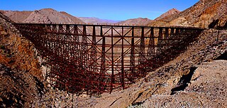
Goat Canyon is a valley in San Diego County, California, United States, located within the Carrizo Gorge in the Jacumba Mountains. The rock forming the canyon is crystalline basement. One feature of the canyon is a dry waterfall. The canyon is bridged by a wooden railroad trestle, the Goat Canyon Trestle, which is the world's largest curved all-wood trestle. The canyon is accessible by trail by traveling west from Mortero Palms.

Yaqui Pass is a mountain pass on CR S3 in San Diego County in the U.S. state of California. The pass lies at an elevation of 1,742 ft (531 m) and is located within the Anza-Borrego Desert State Park approximately 2 mi (3.2 km) east of the SR 78 and traverses the Santa Rosa Mountains.