San Jerónimo is a locality and municipal agency of San Martín de Hidalgo Municipality, Jalisco, Mexico. As of the 2010 census, the village had a total population of 355, making it the eleventh-largest locality in the municipality and the second-largest in the territorial sub-committee.

Ipazoltic is a town in the municipality of San Martín de Hidalgo in the Mexican state of Jalisco. It is known for the lime mines it had, those of which produced the constructional material for the government buildings in Guadalajara.
El Cobre is a rural town in the municipality of San Martín de Hidalgo in the Mexican state of Jalisco. The town is in between the towns of Lagunillas and Mesa del Cobre, in Sierra de Quila, Jalisco's second-largest forest reserve.
Atotonilco el Bajo is a town in the municipality of Villa Corona; in the Mexican state of Jalisco. According to the INEGI census of 2000: 2,255 people resided in the town.
Buenavista de Cañedo, officially Buenavista, is a town in the municipality of San Martín de Hidalgo in the state of Jalisco, Mexico. It has a population of 2,001 inhabitants.
El Crucero de Santa María is a town in the municipality of San Martín de Hidalgo in the state of Jalisco, Mexico. It has a population of 3,228 inhabitants.

El Salitre is a town in the municipality of San Martín de Hidalgo in the state of Jalisco, Mexico. It has a population of 2,434 inhabitants.
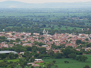
El Tepehuaje de Morelos is a town in the municipality of San Martín de Hidalgo in the state of Jalisco, Mexico. It has a population of 2,163 inhabitants. The town was named after Mexican independence insurgent José María Morelos.
Camajapita is a town in the municipality of San Martín de Hidalgo in the state of Jalisco, Mexico. It has a population of 280 inhabitants. The town takes its name after the adjacent town of Camajapa, which lies on the municipality of Cocula, Jalisco.
Trapiche de Abra is a town in the municipality of San Martín de Hidalgo in the state of Jalisco, Mexico. It has a population of 1,115 inhabitants, 522 men, 592 women.
Jesús María, also known as El Zapote, is a town in the municipality of San Martín de Hidalgo in the state of Jalisco, Mexico. It has a population of 278 inhabitants.
Labor de Medina is a town in the municipality of San Martín de Hidalgo in the state of Jalisco, Mexico. It has a population of 863 inhabitants.

Los Guerrero is a town in the municipality of San Martín de Hidalgo in the state of Jalisco, Mexico. It has a population of 674 inhabitants.
Los Vergara is a town in the municipality of San Martín de Hidalgo in the state of Jalisco, Mexico. It has a population of 269 inhabitants.
Río Grande is a town in the municipality of San Martín de Hidalgo in the state of Jalisco, Mexico. It has a population of 234 inhabitants.
San Isidro Palo Verde is a town in the municipality of San Martín de Hidalgo in the state of Jalisco, Mexico. It has a population of 341 inhabitants.
Santa Rosa del Jilguero is a town in the municipality of San Martín de Hidalgo in the state of Jalisco, Mexico. It has a population of 47 inhabitants.
San Jacinto is a town in the municipality of San Martín de Hidalgo in the state of Jalisco, Mexico. It has a population of 227 inhabitants. It is located on the foothils of the Sierra Madre Oxidental mountain chain.
Ojo de Agua Dam is a dam located southeast of the town of El Tepehuaje de Morelos, Jalisco, Mexico. It is the apparently largest dam in the municipality of San Martín de Hidalgo.