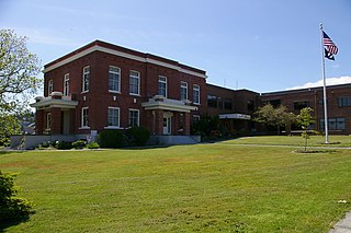
San Juan County is a county located in the Salish Sea in the far northwestern corner of the U.S. state of Washington. As of the 2010 census, its population was 15,769. The county seat and only incorporated city is Friday Harbor, located on San Juan Island. The county was formed on October 31, 1873, from Whatcom County and is named for the San Juan Islands, which are in turn named for Juan Vicente de Güemes, 2nd Count of Revillagigedo, the Viceroy of New Spain.
Chatham Strait, or Shee ya xhaak in the Tlingit language, is a narrow passage of the Alexander Archipelago in the southeastern region of the U.S. state of Alaska. It separates Chichagof Island and Baranof Island to its west from Admiralty Island and Kuiu Island on its east.
Goose Island is one of the San Juan Islands in San Juan County, Washington, United States.

Charlotte is the largest parish of Saint Vincent and the Grenadines, situated on the eastern coast of the island of Saint Vincent. With an area of 149 km², its size is comparable to that of the British Virgin Islands.) The parish has the longest coastline of all the parishes and is also larger than the three smallest parishes combined. The parish possesses a very rough and rugged topography with very little flat land occurring towards the coast. as a result of these features, parts of the north of the parish cannot be accessed by a main road. Up until the building of a bridge over the Rabacca Dry River access to the north side of the river was not possible when rain caused the river to swell and make the path impassable.

The James Madison Memorial Building is one of three United States Capitol Complex buildings that house the Library of Congress. The building was constructed from 1971 to 1976, and serves as the official memorial to President James Madison. It is located between First and Second Streets SE on Independence Avenue, in Washington, DC.

Porlamar is the largest city on Isla Margarita, Nueva Esparta State in Venezuela.
Carrowclare is a small village and townland in County Londonderry, Northern Ireland. In the 2001 Census it had a population of 129 people. It is situated within Causeway Coast and Glens district.
Cedar River is an 11.6-mile-long (18.7 km) stream in Antrim County in the U.S. state of Michigan and is part of the Elk River Chain of Lakes Watershed, a tributary of Lake Michigan.
Sheep Island or Picnic Island is one of the San Juan Islands in San Juan County, Washington, in the United States. It is a tiny island lying just off the eastern shore of West Sound, Orcas Island. Sheep Island has a land area of 6,193 square meters, with a recorded elevation of 23 feet (7.0 m).
Skull Island is the name of two small islands in the San Juan Archipelago in the U.S. state of Washington. The northernmost Skull Island is located off the coast of Orcas Island in Massacre Bay, the most northern extension of the island's West Sound. It is identified as 3.7-acre (1.5 ha) Skull Island State Park Property by the Washington State Parks and Recreation Commission. It was named for holding skulls and bones of a band of Lummi who were killed by raiding Haida in 1858. Since 2013, it has been part of the San Juan Islands National Monument.
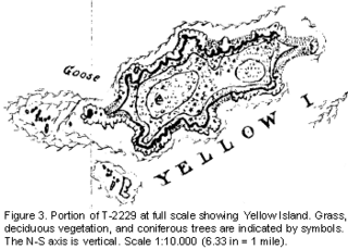
Yellow Island, one of the San Juan Islands, is an 11-acre (4.5 ha) island, located south-west of Orcas Island, and north of Shaw Island, near Jones Island State Park, in San Juan County, Washington, United States. The island is home to a wide array of flora and fauna, including over 50 species of wildflowers, bald eagles, harbor seals, black oystercatchers, and harlequin ducks. The island was purchased in 1979 by The Nature Conservancy, and is administered as a nature preserve.
Raleigh Bay is an indentation of the North Carolina coast, between Cape Lookout in the south and Cape Hatteras in the north. The coastline of the bay is approximately 75 miles (121 km) long, and consists of barrier islands, including Ocracoke Island. It is part of the open Atlantic Ocean and affords no protection from oceanic swells.
ʻŌʻōkala is an unincorporated community on the island of Hawaii in Hawaii County, Hawaii, United States. It lies along Hawaii Route 19 north of Hilo, the county seat of Hawaii County. Its elevation is 371 feet (113 m), and it is located at 20°1′3″N155°17′14″W. Because the community has borne multiple names, the Board on Geographic Names officially designated it "ʻŌʻōkala" in 2000. Although it is unincorporated, it has a post office, with the ZIP code of 96774.
CIOG-FM is a Canadian Christian radio station, broadcasting at 91.3 FM in Charlottetown with a rebroadcaster CIOG-FM-1 at 92.5 FM in Summerside, Prince Edward Island.

The temperate rainforests of Admiralty Island's Kootznoowoo Wilderness are unique among the 5,700,000 acres (2,300,000 ha) of federally protected Wilderness in Southeast Alaska.

Rocky Hill is an unincorporated community in Tulare County, California. It lies at an elevation of 1549 feet.
Uganik is a community in the Kodiak Island Borough of the U.S. state of Alaska. Other variations of the name that have been reported are Oohanick in 1805, Ooganok in the 1880 Census, and Uganak in the 1890 Census.

Chinle Creek is a tributary stream of the San Juan River in Apache County, Arizona and San Juan County, Utah. Its source is at 36°53′40″N109°44′37″W, the confluence of Laguña Creek with Chinle Wash where it forms Chinle Creek, 7 miles northeast of Dennehotso, Arizona at an elevation of 4,774 feet (1,455 m). Its mouth is at its confluence with the San Juan River at 37°11′53″N109°42′57″W at an elevation of 4,229 feet (1,289 m), 9 miles northeast of Mexican Hat, Utah.

Battelle Riverfront Park is a 4.1-acre (1.7 ha) park in downtown Columbus, Ohio, United States, near Columbus City Hall. It is named after Gordon Battelle and was funded by the Battelle Memorial Institute.

Royale Island is the largest and westernmost island of the three Salvation's Islands, in the Atlantic Ocean off the coast of French Guiana. As the largest island, with an area of 28 hectares, it was used as the centre for administration when the islands were used as a penal settlement. With an elevation of 66 metres, the island is the highest of the group. It contains a museum and a hotel as well as an optical and infrared tracking site that supports space launches from the nearby Kourou facility.


