Related Research Articles

The Chihuahuan Desert is a desert and ecoregion designation covering parts of northern Mexico and the southwestern United States. It occupies much of West Texas, the middle and lower Rio Grande Valley, the lower Pecos Valley in New Mexico, and a portion of southeastern Arizona, as well as the central and northern portions of the Mexican Plateau. It is bordered on the west by the Sonoran Desert and the extensive Sierra Madre Occidental range, along with northwestern lowlands of the Sierra Madre Oriental range. On the Mexican side, it covers a large portion of the state of Chihuahua, along with portions of Coahuila, north-eastern Durango, the extreme northern part of Zacatecas, and small western portions of Nuevo León. With an area of about 501,896 km2 (193,783 sq mi), it is the largest desert in North America.

The Sierra Madre Oriental is a mountain range in northeastern Mexico. The Sierra Madre Oriental is part of the American Cordillera, a chain of mountain ranges (cordillera) that consists of an almost continuous sequence of mountain ranges that form the western "backbone" of North America, Central America, South America, and Antarctica.
Donato may refer to:

The Lacandon Jungle is an area of rainforest which stretches from Chiapas, Mexico, into Guatemala. The heart of this rainforest is located in the Montes Azules Biosphere Reserve in Chiapas near the border with Guatemala in the Montañas del Oriente region of the state. Although much of the jungle outside the reserve has been cleared, the Lacandon is still one of the largest montane rainforests in Mexico. It contains 1,500 tree species, 33% of all Mexican bird species, 25% of all Mexican animal species, 56% of all Mexican diurnal butterflies and 16% of all Mexico's fish species.

The Trans-Mexican Volcanic Belt pine–oak forests is a subtropical coniferous forest ecoregion of the Trans-Mexican Volcanic Belt of central Mexico.
Maderas del Carmen is a biosphere reserve in the northern Mexican state of Coahuila.
Donato Guerra is one of 125 municipalities in the State of Mexico, Mexico. It's municipal seat is the town of Villa Donato Guerra, which is the 13th largest town in the municipality of Donato Guerra. The area is also known as Malacatepec and La Asunción Malacatepec. (Villa) Donato Guerra is located in the western part of the State of Mexico. In the region that is identified with Valle de Bravo. The town was named in 1880 in honor of Donato Guerra, a distinguished soldier of the War of La Reforma. It is located around 77 kilometers from Toluca which is the capital of the state, on Federal Highway number 35 Mexico City - Zitácuaro.

Redwood Creek Native Plant Nursery was located just outside the old-growth redwood forest at Muir Woods National Monument. The nursery provided plants for restoration of the creek bank in the lower watershed and impacted areas of the Muir Woods' redwood understory. It was moved to that location in 1992, and closed in 2015.

The Monarch Butterfly Biosphere Reserve is a World Heritage Site containing most of the over-wintering sites of the eastern population of the monarch butterfly. The reserve is located in the Trans-Mexican Volcanic Belt pine-oak forests ecoregion on the border of Michoacán and State of Mexico, 100 km, northwest of Mexico City. Millions of butterflies arrive in the reserve annually. Butterflies only inhabit a fraction of the 56,000 hectares of the reserve from October–March. The biosphere’s mission is to protect the butterfly species and its habitat.
General Donato Guerra (1832-1876) was the leader of the Mexican Army during the time of La Reforma. Born in Jalisco, he participated in the Reform War and in the French intervention. He joined the Plan de la Noria and Tuxtepec.

The forests of Mexico cover a surface area of about 64 million hectares, or 34.5% of the country. These forests are categorized by the type of tree and biome: tropical forests, temperate forests, cloud forests, riparian forests, deciduous, evergreen, dry, moist, etc.. The agency in charge of Mexico's forests is the Comisión Nacional Forestal. Despite major reforms to the Mexican Constitution in 1992 regarding private land, Mexico would later enact major forest regulation laws in 1998 and 2003. Though no longer required to enforce land regulation in Mexico, Article 27 of the Mexican Constitution also still permits the Mexican Government to enact land regulation.
The Tehuacán-Cuicatlán biosphere reserve is a protected natural area located in southeastern Mexico. Its name derives from its two main locations: Cuicatlán and Tehuacán, in the latter are their administrative offices, covers 490,186 hectares distributed among 21 municipalities in the state of Puebla and Oaxaca.
The Gouritz Cluster Biosphere Reserve is located in the Western Cape of South Africa. It is the 7th and largest of South Africa’s biosphere reserves; divided into four connected sectors ranging from sea level to 2,240 metres. The area is the only place in the world where three recognised biodiversity hotspots converge. The site is characterised by high endemism of plant species and threatened invertebrates including seven endemic species of the enigmatic beetle genus Colophon and 14 butterfly species. It provides a migratory route for large mammals such as the leopard and serves as a nursery for marine species.
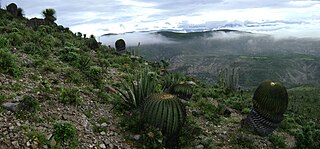
The Mapimí Biosphere Reserve is a UNESCO Biosphere Reserve located in the state of Durango in northern Mexico. It is one of three biosphere reserves representing the Chihuahuan Desert. The 342,388 hectares (1,321.97 sq mi) reserve is situated between the Neotropical and Nearctic biogeographic realms, in the Bolsón de Mapimí 1,150 metres (3,770 ft) above sea level. It contains three core areas in the Sierra de la Campana, the Laguna de las Palomas, a salt lagoon, and a desert habitat called Dunas de la Soledad. It comprises fragile warm desert and semi-desert ecosystems and rich, highly adapted but vulnerable plant systems, mainly xerophytic matorral scrub, and animal species such as the puma, mule deer, sandhill crane and the kit fox or zorrita del desiert along with scrub and desert grasslands.

The Sierra de Manantlán Biosphere Reserve is a UNESCO Biosphere Reserve in the states of Colima and Jalisco, Mexico. The 139,577 hectares (538.91 sq mi) reserve is located in the transition of the Nearctic and Neotropical realms and encompasses parts of the Sierra Madre del Sur, with a wide range of altitudes, climates and soils. The effects of tectonic and volcanic activities and erosion are notable within the reserve.

The Guadalupe Island Biosphere Reserve,, is located in the Pacific Ocean and is part of Baja California state of Mexico. The Reserve consists of Guadalupe Island and several small islands nearby plus a large expanse of surrounding ocean. The Reserve was created by the government of Mexico on 25 April 2005 and is located 250 kilometres (160 mi) from the mainland. The Reserve is 4,770 square kilometres (1,840 sq mi) in size of which 263 square kilometres (102 sq mi) consists of land and the remainder of water.

The Sierra de Álamos–Río Cuchujaqui Flora and Fauna Protection Area, also known as the Sierra de Álamos–Río Cuchujaqui Biosphere Reserve, is a protected area and biosphere reserve in western Mexico. It is located in southeastern Sonora state, along the boundary with Sinaloa and Chihuahua states.
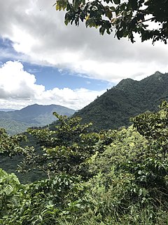
The Sierra de Huautla is a mountain range and biosphere reserve in central Mexico. Located in southern Morelos, the Sierra de Huautla is a southern extension of the Trans-Mexican Volcanic Belt range into the Balsas Basin. The dry forests of Sierra are home to a diverse community of animals and plants, and the reserve's outstanding biodiversity is recognized by UNESCO.

Barranca de Metztitlán is a biosphere reserve in Hidalgo state of Mexico. It is protected for its dramatic scenery of steep cliffs and deep winding canyons, and its distinctive flora and fauna.
El Triunfo Biosphere Reserve is a biosphere reserve in southern Mexico. It is in the Sierra Madre de Chiapas in southern Chiapas.
References
- ↑ "Supervisó Arturo Osornio siete proyectos productivos en Donato Guerra" . Retrieved 2008-02-28.[ permanent dead link ]
- ↑ Quintanar Hinojosa, Beatriz (February 2008). "Breves". Guía México Desconocido: Oaxaca. 372: 8.
| | This article about a location in the state of Mexico is a stub. You can help Wikipedia by expanding it. |