
San Lorenzo (or: Villa San Lorenzo) is a town in the Tarija Department in Bolivia.
San Lorenzo (or: Villa San Lorenzo) is a town in the Tarija Department in Bolivia.
San Lorenzo is the administrative center of Eustaquio Méndez Province and situated at 21°25′00″S64°44′58″W / 21.41667°S 64.74944°W , 2,001 m above sea level, on the left bank of Río Calama, 15 km north of Tarija, the department capital.
San Lorenzo had a population of 2,340 inhabitants according to the 1992 (census), 2,754 inhabitants according to the 2001 census, and was predicted to have more than 3,000 inhabitants by 2007.
San Lorenzo was the home of Eustaquio Méndez, one of the leaders in the fights for the Argentina independence. The local museum Casa del Moto Méndez exhibits some of his personal belongings and weapons.
| Climate data for Coimata, elevation 2,027 m (6,650 ft), (1980–2015) | |||||||||||||
|---|---|---|---|---|---|---|---|---|---|---|---|---|---|
| Month | Jan | Feb | Mar | Apr | May | Jun | Jul | Aug | Sep | Oct | Nov | Dec | Year |
| Record high °C (°F) | 34.8 (94.6) | 35.2 (95.4) | 34.0 (93.2) | 35.0 (95.0) | 36.4 (97.5) | 35.0 (95.0) | 35.8 (96.4) | 35.8 (96.4) | 36.6 (97.9) | 37.0 (98.6) | 38.8 (101.8) | 36.8 (98.2) | 38.8 (101.8) |
| Mean daily maximum °C (°F) | 25.5 (77.9) | 25.2 (77.4) | 24.8 (76.6) | 24.2 (75.6) | 23.8 (74.8) | 24.0 (75.2) | 23.8 (74.8) | 25.0 (77.0) | 25.4 (77.7) | 26.6 (79.9) | 26.2 (79.2) | 25.9 (78.6) | 25.0 (77.1) |
| Daily mean °C (°F) | 19.8 (67.6) | 19.4 (66.9) | 18.9 (66.0) | 17.5 (63.5) | 14.9 (58.8) | 13.6 (56.5) | 13.3 (55.9) | 15.0 (59.0) | 16.6 (61.9) | 18.9 (66.0) | 19.3 (66.7) | 19.8 (67.6) | 17.3 (63.0) |
| Mean daily minimum °C (°F) | 14.0 (57.2) | 13.5 (56.3) | 13.0 (55.4) | 10.7 (51.3) | 6.1 (43.0) | 3.1 (37.6) | 2.9 (37.2) | 4.9 (40.8) | 7.7 (45.9) | 11.2 (52.2) | 12.4 (54.3) | 13.6 (56.5) | 9.4 (49.0) |
| Record low °C (°F) | 7.3 (45.1) | 2.2 (36.0) | 2.3 (36.1) | −2.6 (27.3) | −6.4 (20.5) | −9.8 (14.4) | −10.5 (13.1) | −8.7 (16.3) | −6.2 (20.8) | 0.9 (33.6) | 1.0 (33.8) | 4.8 (40.6) | −10.5 (13.1) |
| Average precipitation mm (inches) | 158.0 (6.22) | 139.0 (5.47) | 109.6 (4.31) | 30.4 (1.20) | 3.1 (0.12) | 0.6 (0.02) | 0.7 (0.03) | 2.8 (0.11) | 11.1 (0.44) | 41.0 (1.61) | 70.4 (2.77) | 153.2 (6.03) | 719.9 (28.33) |
| Average precipitation days | 14.1 | 12.8 | 11.1 | 4.7 | 1.3 | 0.3 | 0.5 | 0.9 | 2.4 | 6.1 | 8.9 | 12.8 | 75.9 |
| Average relative humidity (%) | 72.5 | 74.9 | 76.0 | 72.1 | 65.3 | 57.2 | 54.0 | 53.5 | 55.1 | 60.3 | 61.3 | 69.5 | 64.3 |
| Source: Servicio Nacional de Meteorología e Hidrología de Bolivia [1] [2] | |||||||||||||
| Climate data for Tucumillas, elevation 2,560 m (8,400 ft) (1977–2015) | |||||||||||||
|---|---|---|---|---|---|---|---|---|---|---|---|---|---|
| Month | Jan | Feb | Mar | Apr | May | Jun | Jul | Aug | Sep | Oct | Nov | Dec | Year |
| Mean daily maximum °C (°F) | 20.8 (69.4) | 20.4 (68.7) | 20.2 (68.4) | 19.8 (67.6) | 19.7 (67.5) | 20.9 (69.6) | 20.3 (68.5) | 21.2 (70.2) | 21.4 (70.5) | 22.2 (72.0) | 21.8 (71.2) | 21.6 (70.9) | 20.9 (69.5) |
| Daily mean °C (°F) | 15.8 (60.4) | 15.5 (59.9) | 15.3 (59.5) | 14.2 (57.6) | 12.5 (54.5) | 12.6 (54.7) | 11.8 (53.2) | 12.7 (54.9) | 13.4 (56.1) | 15.4 (59.7) | 15.6 (60.1) | 16.1 (61.0) | 14.2 (57.6) |
| Mean daily minimum °C (°F) | 10.7 (51.3) | 10.6 (51.1) | 10.4 (50.7) | 8.6 (47.5) | 5.4 (41.7) | 4.3 (39.7) | 3.3 (37.9) | 4.2 (39.6) | 5.4 (41.7) | 8.7 (47.7) | 9.4 (48.9) | 10.6 (51.1) | 7.6 (45.7) |
| Average precipitation mm (inches) | 186.8 (7.35) | 172.2 (6.78) | 136.0 (5.35) | 29.2 (1.15) | 4.7 (0.19) | 0.9 (0.04) | 2.3 (0.09) | 4.0 (0.16) | 8.9 (0.35) | 40.8 (1.61) | 76.3 (3.00) | 146.3 (5.76) | 808.4 (31.83) |
| Average precipitation days | 13.6 | 12.5 | 11.4 | 4.7 | 1.4 | 0.6 | 0.5 | 0.7 | 1.8 | 5.5 | 8.0 | 11.2 | 71.9 |
| Source: Servicio Nacional de Meteorología e Hidrología de Bolivia [3] [4] | |||||||||||||

Aniceto Arce is a province in the southern parts of the Bolivian department Tarija. The province is named after Aniceto Arce Ruiz (1824-1906), President of Bolivia from 1888 until 1892.
Padcaya is a town in the Tarija Department in southeastern Bolivia.

Entre Ríos is a town in the Bolivian Tarija Department.
Uriondo is a town in the Bolivian Tarija Department.

Iscayachi is a sparsely populated town in the Bolivian high valleys, located at the Eustaquio Méndez province Junction, north Tarija, at an elevation of 2,915 meters. The population is reported to be 1,153.
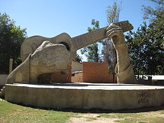
Aiquile is a town in the Cochabamba Department, Bolivia. It is the capital of the Narciso Campero Province and Aiquile Municipality. Most of its population is Quechua, and its residents are reputed to be the best charango makers in the country.
Batallas is a location in the La Paz Department in Bolivia. It is the seat of the Batallas Municipality, one of the four municipalities of the Los Andes Province.
Caquiaviri is a location in the La Paz Department in Bolivia. It is the seat of the Caquiaviri Municipality, the second municipal section of the Pacajes Province.

Irupana is a location in the La Paz Department in Bolivia. It is the seat of the Irupana Municipality, the second municipal section of the Sud Yungas Province.

Puerto Acosta or Waychu (Aymara) is a town in the La Paz Department, Bolivia.

Culpina is a small town in Bolivia. In 2010 it had an estimated population of 2,747.
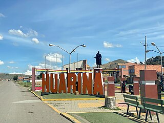
Huarina is a location in the La Paz Department in Bolivia. It is the seat of the Huarina Municipality, one of the four municipalities of the Omasuyos Province. President of Peru Andrés de Santa Cruz was born here.
Santuario de Quillacas is a small town in the Oruro Department in Bolivia. It is situated south east of Poopó Lake.
Tinguipaya is a small town in Bolivia, Potosí Department, Tomás Frías Province. It is the seat of the Tinguipaya Municipality.

San Agustín is a village located in the Potosí Department of Bolivia. It is the capital of the San Agustín Canton, San Agustín Municipality and Enrique Baldivieso Province.
Puna is a village and the capital of the José María Linares Province in the Potosí Department of Bolivia.
Colcha K is a village serving as the capital of Nor Lípez Province, in the Potosí Department of Bolivia. It is also the capital of the Colcha "K" Canton and Colcha "K" Municipality.
Betanzos is a town located in the Potosí Department of Bolivia. It is the capital of the Betanzos Canton, Betanzos Municipality and Cornelio Saavedra Province.
Canasmoro is a town in the Tarija Department of Bolivia.
Palmar Grande is a town in the Tarija Department of Bolivia.