
Mission San Luis Obispo de Tolosa is a Spanish mission founded September 1, 1772 by Father Junípero Serra in San Luis Obispo, California. Named after Saint Louis of Anjou, the bishop of Toulouse, the mission is the namesake of San Luis Obispo.

San Luis Obispo County, officially the County of San Luis Obispo, is a county on the Central Coast of California. As of the 2020 census, the population was 282,424. The county seat is San Luis Obispo.

San Luis Obispo is a city and county seat of San Luis Obispo County, in the U.S. state of California. Located on the Central Coast of California, San Luis Obispo is roughly halfway between the San Francisco Bay Area in the north and Greater Los Angeles in the south. The population was 47,063 at the 2020 census.

Los Osos is an unincorporated town in San Luis Obispo County, California, United States. Located on the Central Coast of California, Los Osos had a population estimated to be 16,533 in 2019. For statistical purposes, the United States Census Bureau has defined Los Osos as a census-designated place (CDP).

Guadalupe-Nipomo Dunes is the largest remaining dune system south of San Francisco and the second largest in the U.S. state of California. It encompasses an 18-mile (29 km) stretch of coastline on the Central Coast of California and extends from southern San Luis Obispo County to northern Santa Barbara County.

Montaña de Oro is a state park in Central Coastal California, six miles southwest of Morro Bay and two miles south of Los Osos.
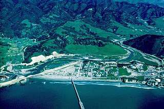
San Luis Obispo Creek is a stream, about 18 miles (29 km) long, in San Luis Obispo County, California. It drains a large coastal watershed that includes the city of San Luis Obispo, emptying into the Pacific Ocean at Avila Beach.
California's 24th congressional district is a congressional district in the U.S. state of California. The district is currently represented by Salud Carbajal. It contains all of Santa Barbara County, most of San Luis Obispo County, and part of Ventura County. Cities in the district include Santa Barbara, Ventura, San Luis Obispo, Santa Maria, and Ojai.
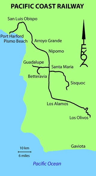
The Pacific Coast Railway was a 3 ft narrow gauge railway on the Central Coast of California. The original 10-mile (16 km) link from San Luis Obispo to Avila Beach and Port Harford was later built southward to Santa Maria and Los Olivos, with branches to Sisquoc and Guadalupe.
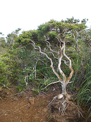
Dwarf forest, elfin forest, or pygmy forest is an uncommon ecosystem featuring miniature trees, inhabited by small species of fauna such as rodents and lizards. They are usually located at high elevations, under conditions of sufficient air humidity but poor soil. There are two main dwarf forest ecosystem types, involving different species and environmental characteristics: coastal temperate and montane tropical regions. Temperate coastal dwarf forest is common for parts of Southern California. Montane tropical forests are found across tropical highlands of Central America, northern South America and Southeast Asia. There are also other isolated examples of dwarf forests scattered across the world, while the largest dwarf forest is found in the Philippines.
The Paso Robles Event Center, formerly California Mid-State Fairgrounds, is an entertainment complex located in Paso Robles, California. The site opened in 1946 for the annual "California Mid-State Fair".

Edna Valley is an American Viticultural Area (AVA) located in San Luis Obispo (SLO) County, California encompassing the rural town of Edna which is 9 miles (14 km) southeast of the county seat San Luis Obispo and north of the small coastal town Arroyo Grande. It was established by the Bureau of Alcohol, Tobacco and Firearms (ATF) as the county's first AVA within California’s multi-county Central Coast AVA effective May 12, 1982. It became an sub-appellation of the county’s newest San Luis Obispo Coast viticultural area since April 2022. The valley is diagonally flanked by Lake Lopez to the south and Islay Hill to the north. The elongated valley extends along a northwest-southeast axis bordered to the west by the Santa Lucia Mountains and surrounded by volcanic mountains and characterized by black humus and clay-rich soils. With moderate sunshine, cool maritime fog, and rich oceanic and volcanic soils, the Edna Valley appellation has California's longest growing season. The valley is kept cool by breezes from the Pacific Ocean and morning fog. The extended growing season allows complex flavors to develop in the grapes.
Harmony Headlands State Park preserves an undeveloped parcel of Pacific coast in California, United States. Located in San Luis Obispo County on Highway 1, the park is the only public access to the coast between the towns of Cayucos and Harmony. The 748-acre (303 ha) park was established in 2003. The Cayucos Land Conservancy helped facilitate and fund the park's development.
An octagon barn is a barn built in an octagonal shape, see Round barn § Octagonal.

The Land Conservancy of San Luis Obispo County (LCSLO) is a non-profit land trust organization that has been operating in San Luis Obispo County, California since 1984. The LCSLO is dedicated to the voluntary and collaborative preservation and improvement of lands that hold significant scenic, agricultural, habitat, and cultural values. Their work aims to benefit both the local community and wildlife that depends on these lands.
The San Luis Obispo Regional Transit Authority is the provider of intercity mass transportation in San Luis Obispo County, California, with service between most cities in the county: Arroyo Grande, Atascadero, Paso Robles, Grover Beach, Morro Bay, Pismo Beach, Cambria, San Simeon, Los Osos, Cayucos, and San Luis Obispo. Hourly routes operate Monday - Friday, with limited Saturday & Sunday service. The base travel fare is $1.75-$3.25 each way, or a Regional day pass may be purchased for $5.50, good for unlimited trips on all fixed-routes in the county. Five routes are branded as part of the SLORTA. RTA also operates fixed route transit service in Paso Robles and the Five Cities Area for South County Transit and the Avila Beach Trolley on a seasonal/summer runs.
Rancho Corral de Tierra was a 7,766-acre (31.43 km2) Mexican land grant in present-day coastal western San Mateo County, northern California.

The San Luis Obispo City Fire Department provides fire protection and emergency response services for the city of San Luis Obispo, California and protects a population of approximately 47,000 people; however that number increases to over 100,000 during weekdays. In addition to the city, the department is also responsible for California Polytechnic State University which adds at approximately 24,000 people to the responsible population. San Luis Obispo also neighbors the Diablo Canyon Nuclear Power Plant and provides mutual aid to the plant during emergencies.
The City of San Luis Obispo Historic Resources consists of buildings and sites designated by the City of San Luis Obispo, California, as historic resources.

Amphibious Training Base Morro Bay also called Camp Morro Bay and Morro Bay Section Base was a US Navy training base for amphibious beach assault during World War II. The base opened in 1941 to train troops for the Pacific theater of operations' island leapfrogging using landing craft and LCVP. The base was located in Morro Bay, California in San Luis Obispo County. The base was on 250 acres (100 ha) of leased land. Ships for the base were based at the Avila's Port San Luis in San Luis Bay. Which was also leased with the yacht club and its warehouse. Added to the leased land was: two piers, mess hall, gallon water storage tanks, roads, buildings, garages, and ammo storage area. The Navy also extended the bay's breakwater. A wooden trestle bridge was built to get to the nearby sandspit, the bridge was removed in 1946 and some pillars still remain. The near Estero Bay was the site of training assault also, by the Navy, US Army, US Marine Corps and United States Coast Guard also taking over the unused vacation hotel there. Nearby United States Army Air Corps fields had fighter aircraft fire flour shot to make the training more real. Up to 175 landing craft were at the base and 16,000 troops a day trained. In the base and in nearby Los Osos and Baywood live fire bombing, machine gun, bazookas, and flamethrowers were used for training. The training ended on 31 October 1945 and the site is now a Duke Energy power plant built in 1955, site of three large smoke stacks. North of the former base in the notable Morro Rock. Avila Beach was also a Union Oil plant with many oil storage tanks, use for Navy ships.

