
Savannah is the oldest city in the U.S. state of Georgia and the county seat of Chatham County. Established in 1733 on the Savannah River, the city of Savannah became the British colonial capital of the Province of Georgia and later the first state capital of Georgia. A strategic port city in the American Revolution and during the American Civil War, Savannah is today an industrial center and an important Atlantic seaport. It is Georgia's fifth most populous city, with a 2020 U.S. census population of 147,780. The Savannah metropolitan area, Georgia's third-largest, had a 2020 population of 404,798.

Louisville is a city in and the county seat of Jefferson County, Georgia, United States, and also a former state capital of Georgia. It is located southwest of Augusta on the Ogeechee River, and its population was 2,493 at the 2010 census, down from 2,712 at the 2000 census. By 2020, its population was 2,381. Its name is pronounced "Lewis-ville", though it and the differently pronounced city in Kentucky were both named for Louis XVI.

Sanborn maps are detailed maps of U.S. cities and towns in the 19th and 20th centuries. Originally published by The Sanborn Map Company (Sanborn), the maps were created to allow fire insurance companies to assess their total liability in urbanized areas of the United States. Since they contain detailed information about properties and individual buildings in approximately 12,000 U.S. cities and towns, Sanborn maps are valuable for documenting changes in the built environment of American cities over many decades.
Wallace Augustus Rayfield (1874–1941), was an American architect and educator. He was the second formally educated practicing African American architect in the United States.
The city of Savannah, Province of Georgia, was laid out in 1733, in what was colonial America, around four open squares, each surrounded by four residential ("tything") blocks and four civic ("trust") blocks. The layout of a square and eight surrounding blocks was known as a "ward." The original plan was part of a larger regional plan that included gardens, farms, and "out-lying villages." Once the four wards were developed in the mid-1730s, two additional wards were laid. Oglethorpe's agrarian balance was abandoned after the Georgia Trustee period. Additional squares were added during the late 18th and 19th centuries, and by 1851 there were 24 squares in the city. In the 20th century, three of the squares were demolished or altered beyond recognition, leaving 21. In 2010, one of the three "lost" squares, Ellis, was reclaimed, bringing the total to today's 22.
The Digital Library of Georgia (DLG) is an online, public collection of documents and media about the history and culture of the state of Georgia, United States. The collection includes more than a million digitized objects from more than 200 Georgia-related collections. The DLG connects users to content from 65 libraries, archives, museums, historical societies, and other institutions, as well as 100 agencies of state government. It can be searched or browsed through the Digital Library of Georgia website.

The Courier is a daily newspaper based in Findlay, Ohio. It is delivered primarily to Hancock County and parts of Wyandot, Putnam, Seneca, Wood, Allen and Henry counties in Ohio. It was owned and operated by the Heminger family of Findlay for 131 years before being sold in November 2019 to Ogden Newspapers of Wheeling, West Virginia. The Courier is still headquartered and published in Findlay.

Murder Bay was a disreputable slum in Washington, D.C., roughly bounded by Constitution Avenue NW, Pennsylvania Avenue NW, and 13th and 15th Streets NW. The area was a center of crime through the early 20th century, with an extensive criminal underclass and prostitution occurring in several brothels and hotels in the area. The area was completely rebuilt during the construction of the Federal Triangle project in the late 1920s and 1930s.
The following is a timeline of the history of Savannah, Georgia, United States.

The Oliver Sturges House is a historic building in Savannah, Georgia, United States, built in 1813. It is located in the southwestern trust block of Reynolds Square, and it was placed on the National Register of Historic Places in 1971. The building has also been known as the Hiram Roberts House. Roberts lived from 1806 to 1880. The house was originally two floors; a third was added in 1835.
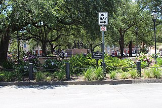
Franklin Square is one of the 22 squares of Savannah, Georgia, United States. It is located in the northernmost row of the city's five rows of squares, at Montgomery Street and West St. Julian Street. It is west of Ellis Square in the northwestern corner of the city's grid of squares. The square now anchors the western end of the City Market retail area.

Johnson Square is one of the 22 squares of Savannah, Georgia, United States. Located in the northernmost row of the city's five rows of squares, it was the first of the squares to be laid out, in 1733, and remains the largest of the 22. It is east of Ellis Square, west of Reynolds Square and north of Wright Square. Situated on Bull Street and St. Julian Street, it is named for Robert Johnson, colonial governor of South Carolina and a friend of General James Oglethorpe. The oldest building on the square is the Ann Hamilton House, at 26 East Bryan Street, which dates to 1824.
Washington Square is one of the 22 squares of Savannah, Georgia, United States. It is located in the northernmost row of the city's five rows of squares, on Houston Street and East St. Julian Street. It is east of Warren Square and north of Greene Square in the northeastern corner of the city's grid of squares. The oldest building original to the square is 510 East St. Julian Street, which dates to 1797.

Factors Walk, also commonly spelled Factor's Walk or Factors' Walk, is a historic street in Savannah, Georgia, United States. It runs for about 0.4 miles (0.64 km) along the upper levels of the southern frontages of the buildings of Factors Row, which is located between River Street to the north and Bay Street, around 40 feet (12 m) above on the bluff, to the south. Although this difference in elevation was advantageous in terms of defense, it did not provide easy movement between the working waterfront and the city above.

Martin Luther King Jr. Boulevard is a prominent street in Savannah, Georgia, United States. Located to the west of Montgomery Street, at the western edge of Savannah's downtown, it runs for about 2.48 miles (3.99 km) from West River Street in the north to Exchange Street in the south. Originally called West Broad Street, it was renamed for Martin Luther King Jr. in 1991. A memorial bust of King Jr., designed by Italian sculptor Franco Castelluccio and approved by his family, was officially unveiled at Martin Luther King Jr. Park in Savannah's Plant Riverside District on January 15, 2022. The memorial is located at the northern terminus of the boulevard, overlooking the Savannah River.

The Hampton Lillibridge House is a historic home in Savannah, Georgia, United States. It is located at 507 East St. Julian Street, in the southwestern civic/trust lot of Washington Square, and was built around 1797. One of the oldest extant buildings in Savannah, it is now part of the Savannah Historic District. In a survey for the Historic Savannah Foundation, Mary Lane Morrison found the building, constructed by Rhode Island native Hampton Lillibridge, to be of significant status.

The William Remshart Row House is a historic building in Savannah, Georgia, United States. It comprises the four properties between 102 and 111 West Jones Street, and was completed in 1853. It is a contributing property of the Savannah Historic District, itself on the National Register of Historic Places.

Indian Street is a historic street in Savannah, Georgia, United States. It runs for about 0.34 miles (0.55 km) from Warner Street in the west to Martin Luther King Jr. Boulevard in the east. It is immediately to the south of the Talmadge Memorial Bridge. The street is so named because it passes through Yamacraw Village, itself named for the Yamacraw Native Americans, who lived on Savannah's Yamacraw Bluff.
