The City of Brimbank is a local government area located within the metropolitan area of Melbourne, Victoria, Australia. It comprises the western suburbs between 10 and 20 km west and northwest from the Melbourne city centre.
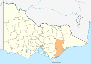
The Shire of Wellington is a local government area in Victoria, Australia, located in the eastern part of the state. It covers an area of 10,989 square kilometres (4,243 sq mi) and at the 2016 Census had a population of almost 43,000.

Northcote is an inner suburb of Melbourne, Victoria, Australia, 6 km north-east of Melbourne's Central Business District. It is part of the local government area of the City of Darebin. At the 2016 Census, Northcote had a population of 24,561.

Ringwood is a suburb of Melbourne, Victoria, Australia, 23 km (14 mi) east of Melbourne's Central Business District. Its local government area is the City of Maroondah. At the 2011 Census, Ringwood had a population of 10,009. Ringwood has many parks reserves, most notably, Ringwood Lake. As of July 2012, the average house price in Ringwood was $583,500 and $390,000 for a unit.

Torquay is a seaside resort in Victoria, Australia, which faces Bass Strait, 21 km south of Geelong and is the gateway to the Great Ocean Road. It is bordered on the west by Spring Creek and its coastal features include Point Danger and Zeally Bay. At the 2016 Census, Torquay had a population of 13,258.

Clayton South is a suburb in Melbourne, Victoria, Australia, 21 km south-east from Melbourne's central business district. Its local government area is the City of Kingston. At the 2016 census, Clayton South had a population of 12,642.
Altona North is a suburb of Melbourne, Victoria, Australia, 10 km south-west of Melbourne's Central Business District, located within the City of Hobsons Bay local government area. Altona North recorded a population of 12,152 at the 2016 census. Bordering suburbs include Altona, Brooklyn, Laverton North, Newport, South Kingsville, Williamstown North, Yarraville. In addition to Paisley Park sporting complex, Altona North is home to three parks, S J Clement Reserve - Gilligan Rd, W L J Crofts Reserve - Blackshaws Rd, Urban Forest Reserve - Grieve Pde.

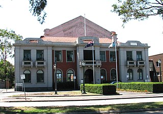
Brunswick Town Hall is located on the corner of Sydney Road and Dawson Street in the inner northern Melbourne suburb of Brunswick, Victoria, Australia.

Victoria Street is one of the major thoroughfares of inner Melbourne, running east-west for over six kilometres between Munster Terrace in North Melbourne and the Yarra River. The road is known as Victoria Parade for over one-and-a-half kilometres of its length, distinguishable with a wide reservation and tramway down the middle.

Melbourne is considered to be Australia's garden city, and Victoria as the Garden State. There is an abundance of parks and gardens close to the CBD with a variety of common and rare plant species amid landscaped vistas, pedestrian pathways, and tree lined avenues. The phrase Victoria – Garden State was used on Victorian car number plates from the 1970s to 1994, and many regional towns have well tended botanic gardens, parks and tree lined avenues.

Melbourne Sports and Aquatic Centre (MSAC) is an international sporting venue located in Albert Park, Victoria, Australia. The centre was opened on 24 July 1997 at a construction cost of A$65 million. The cost was funded by the State Government of Victoria and the City of Port Phillip. The center has hosted international events including the 2006 Commonwealth Games and the 2007 World Aquatics Championships.

Queens Park is a significant park in Moonee Ponds in the City of Melbourne, Australia
Williamstown High School is a public co-educational secondary school located in the Melbourne suburb of Williamstown. Williamstown or 'Willi' high is one of four government schools in the Western Suburbs of Melbourne. It is a multi-campus school with both campuses located within walking distance. The two campuses are known as Bayview street and Pasco street campus. It is known to be one of the first public schools in Melbourne with a history of over 100 years.
South Kingsville is a suburb of Melbourne, Victoria, Australia, 8 km south-west of Melbourne's central business district. Its local government area is the City of Hobsons Bay. At the 2016 census, South Kingsville had a population of 1,947.
The Skeleton Creek Trail is a shared use path for cyclists and pedestrians, which follows Skeleton Creek as it passes through the outer south western suburbs of Point Cook and Altona Meadows in Melbourne, Victoria, Australia.
The Geelong Golf Club is a defunct golf club founded in 1892 and was the oldest in the state of Victoria, Australia. It was located in the northern Geelong suburb of North Geelong and maintained an 18-hole course bounded by Ballarat Road and bisected by Thompson Road.
Jolimont is an unbounded neighbourhood of the suburb of East Melbourne, Victoria, Australia. Situated to the south east of the city's primary axis, Jolimont features parks, business precincts and a limited amount of residential accommodation. It was named after the Jolimont estate of Lieutenant-Governor Charles La Trobe, Victoria's first governor from 1839 to 1854.
Williamstown Town Hall is a civic building located in Williamstown, a suburb of Melbourne, Australia.
Delacombe is a large and rapidly growing industrial/residential suburb on the south west rural-urban fringe of Ballarat, Victoria, Australia. The population at the 2016 census was 6,297 making it the fourth most populated in the Ballarat urban area.
The Northcote Farm School (NFS) was a farm school built at Glenmore, near Bacchus Marsh, Victoria, in 1937.