
Smiths Falls is a town in Eastern Ontario, Canada, 72 kilometres (45 mi) southwest of Ottawa. As of the 2021 census it has a population of 9,254. It is in the Census division for Lanark County, but is separated from the county. The Rideau Canal waterway passes through the town, with four separate locks in three locations and a combined lift of over 15 metres (49.2 ft).

Arnprior is a town in Renfrew County, in the eastern portion of Southern Ontario, Canada. It is located 65 km (40 mi) west of Downtown Ottawa, at the confluence of the Madawaska River and the Ottawa River in the Ottawa Valley. Arnprior has experienced significant growth in populations with the widening of the 417 Provincial Highway to four lanes. The town experienced an increase in population by 8.4% from 2011 to 2016, at which time its population was 8,795. The town is a namesake of Arnprior, Scotland, and is known for lumber, hydro power generation, aerospace, farming and its proximity to the National Capital Region.
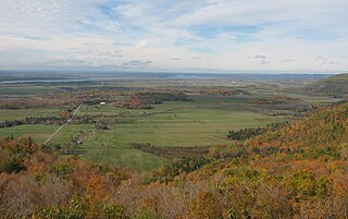
The Ottawa Valley is the valley of the Ottawa River, along the boundary between Eastern Ontario and the Outaouais, Quebec, Canada. The valley is the transition between the Saint Lawrence Lowlands and the Canadian Shield. Because of the surrounding shield, the valley is narrow at its western end and then becomes increasingly wide as it progresses eastward. The underlying geophysical structure is the Ottawa-Bonnechere Graben. Approximately 1.3 million people reside in the valley, around 80% of whom reside in Ottawa. The total area of the Ottawa Valley is 2.4 million ha. The National Capital Region area has just over 1.4 million inhabitants in both provinces.

McNab/Braeside is a township in eastern Ontario, Canada, on the south shore of Chats Lake, straddling the lower Madawaska River in Renfrew County.
The Canadian Northern Railway (CNoR) was a historic Canadian transcontinental railway. At its 1923 merger into the Canadian National Railway, the CNoR owned a main line between Quebec City and Vancouver via Ottawa, Winnipeg, and Edmonton.
King's Highway 17, more commonly known as Highway 17, is a provincially maintained highway and the primary route of the Trans-Canada Highway through the Canadian province of Ontario. It begins at the Manitoba boundary, 50 km (31 mi) west of Kenora, and the main section ends where Highway 417 begins just west of Arnprior. A small disconnected signed section of the highway still remains within the Ottawa Region between County Road 29 and Grants Side Road. This makes it Ontario's longest highway.

Depot Harbour is a ghost town on Wasauksing First Nation, in the Parry Sound District, Ontario, Canada. It was once the western terminus of the Canada Atlantic Railway and a busy port on Georgian Bay.
King's Highway 417, commonly referred to as Highway 417 and as the Queensway through Ottawa, is a 400-series highway in the Canadian province of Ontario. It connects Ottawa with Montreal via A-40, and is the backbone of the highway system in the National Capital Region. Within Ottawa, it forms part of the Queensway west from Highway 7 to Ottawa Road 174. Highway 417 extends from the Quebec border, near Hawkesbury, to Arnprior, where it continues westward as Highway 17. Aside from the urban section through Ottawa, Highway 417 passes through farmland that dominates much of the fertile Ottawa Valley.

Toronto Harbour or Toronto Bay is a natural bay on the north shore of Lake Ontario, in Toronto, Ontario, Canada. Today, the harbour is used primarily for recreational boating, including personal vessels and pleasure boats providing scenic or party cruises. Ferries travel from docks on the mainland to the Islands, and cargo ships deliver aggregates and raw sugar to industries located in the harbour. Historically, the harbour has been used for military vessels, passenger traffic and cargo traffic. Waterfront uses include residential, recreational, cultural, commercial and industrial sites.

The Brockville Railway Tunnel, also called the Brockville Tunnel, is a former railway tunnel located beneath the downtown of Brockville, Ontario, Canada. It is the first railway tunnel built in Canada; construction began in September 1854 and the first train passed through the tunnel on December 31, 1860. Since 2017 it has been opened to the public as a free seasonal tourist attraction.

Alameda Terminal was a railroad station and ferry wharf at the foot and west of present-day Pacific Avenue and Main Street in Alameda, California, on the eastern shore of San Francisco Bay with ferry service to San Francisco. It was built in 1864 and operated by the San Francisco and Alameda Railroad. In 1869, it served as the original west coast terminus of the U.S. First transcontinental railroad, until the opening of Oakland Pier two months later. The western terminus was inaugurated September 6, 1869, when the first Western Pacific through train from Sacramento reached the shores of San Francisco Bay at Alameda Terminal, — thus completing the first transcontinental railroad "from the Missouri river to the Pacific ocean" in accordance with the Pacific Railroad Acts.

The Parry Sound Colonization Railway Company (PSCR) was a Canadian railway that operated in Ontario. It originally intended to connect the town of Parry Sound to the Northern and Pacific Junction Railway but ran out of funds shortly after starting construction. The line was purchased by John Rudolphus Booth in 1892 to form the western end of his Ottawa, Arnprior and Parry Sound Railway. Failing to come to an agreement on the location of an associated port, the line ultimately bypassed the town completely, running to Depot Harbour, a company town.
The Ottawa, Arnprior and Parry Sound Railway, or OA&PS, is a historic railway that operated in central and eastern Ontario, Canada from 1897 until 1959. It was, for a time, the busiest railway route in Canada, carrying both timber and wood products from today's Algonquin Provincial Park areas, as well as up to 40% of the grain traffic from the Canadian west from Depot Harbour at Parry Sound through to the St. Lawrence River valley.
The Canada Atlantic Railway (CAR) was a North American railway located in Ontario, southwestern Quebec and northern Vermont. It connected Georgian Bay on Lake Huron with the northern end of Lake Champlain via Ottawa. It was formed in 1879 through a merger of two separate railway companies that John Rudolphus Booth had purchased, and reached its full extent in 1899 through a third company that he had created. The CAR was owned by Booth for several years after its completion until he agreed to sell it to the Grand Trunk Railway (GTR) in 1904.
The Northern and Pacific Junction Railway (N&PJ) is a historic railway located in northern Ontario, Canada. It connected the Northern Railway of Canada's endpoint in Gravenhurst to the Canadian Pacific Railway (CPR) at Nipissing Junction, near North Bay. The N&PJ provided an almost straight line north-south route from Toronto to the transcontinental line, competing with a similar line of the Canadian Northern Railway (CNoR) a short distance to the west.

Bristol is a municipality in the Ottawa Valley, on the Quebec side in the Outaouais region, part of the Pontiac Regional County Municipality, Quebec, Canada. It is located on the north shore of Lac des Chats across from Arnprior, Ontario.

SS Princess Helene was a passenger and cargo ferry operated by the Canadian Pacific Railway (CPR).

This is the outline of the geography of the city of Ottawa, the capital of Canada. Ottawa's current borders were formed in 2001, when the former city of Ottawa amalgamated with the ten other municipalities within the former Regional Municipality of Ottawa–Carleton. Ottawa is now a single-tiered census division, home to 1,017,449 people.

The Railway Museum of Eastern Ontario, a rail museum in a former CNoR station, stands on the abandoned right-of-way of a Canadian Northern Railway line which once led southwest toward Napanee. Established 1985 as the Smiths Falls Railway Museum, the RMEO works to preserve the 1913 Canadian Northern (CNoR) station and a collection of historic rolling stock, equipment and railway memorabilia.
