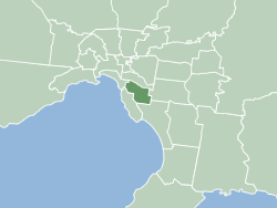
The City of Glen Eira is a local government area in Victoria, Australia. It is located in the south-eastern suburbs of Melbourne. It has an area of 39 square kilometres (15.06 sq mi) and has an estimated population of 153,858. It was formed in 1994 from the merger of the City of Caulfield and parts of the City of Moorabbin, and takes its name from two local landmarks—Glen Eira Road and Glen Eira Mansion.

Caulfield is a suburb of Melbourne, Victoria, Australia, 12 kilometres (7.5 mi) south-east of Melbourne's central business district. Its local government area is the City of Glen Eira.

Carnegie is a suburb in Melbourne, Victoria, Australia, 12 km south-east of Melbourne's central business district. Its local government area is the City of Glen Eira. At the 2016 Census, Carnegie had a population of 17,388. Its postcode is 3163.

Murrumbeena is a suburb in Melbourne, Victoria, Australia, 13 km south-east of Melbourne's central business district. Its local government area is the City of Glen Eira. At the 2016 Census, Murrumbeena had a population of 9,926.
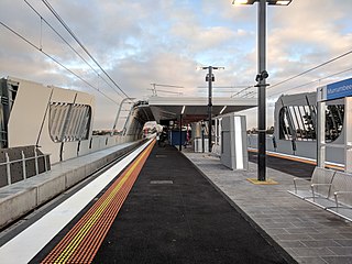
Murrumbeena railway station is located on the Pakenham and Cranbourne lines in Victoria, Australia. It serves the south-eastern Melbourne suburb of Murrumbeena, and it opened on 14 May 1879.

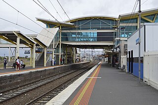
Oakleigh railway station is located on the Pakenham and Cranbourne lines in Victoria, Australia. It serves the south-eastern Melbourne suburb of Oakleigh, and it opened on 8 October 1877.

Clayton railway station is located on the Pakenham and Cranbourne lines in Victoria, Australia. It serves the south-eastern Melbourne suburb of Clayton, and opened on 6 January 1880 as Clayton's Road. It was renamed Clayton on 6 July 1891.
Dandenong railway station is the junction station for the Pakenham and Cranbourne lines in Victoria, Australia. It serves the south-eastern Melbourne suburb of Dandenong, and it opened on 8 October 1877.

Hughesdale is a suburb in Melbourne, Victoria, Australia, 14 km south-east of Melbourne's central business district. Its local government area is the City of Monash. At the 2016 Census, Hughesdale had a population of 7,556.
Oakleigh South is a suburb in Melbourne, Victoria, Australia, 17 km south-east of Melbourne's central business district. Its local government area is the City of Monash and the City of Kingston. At the 2016 Census, Oakleigh South had a population of 9,261.

The electoral district of Caulfield is an electoral district of the Victorian Legislative Assembly. The electorate is surrounded by the other electoral districts of Prahran, Albert Park, Malvern, Oakleigh, Bentleigh and Brighton.

Caulfield Football Club was an Australian rules football club which played in the VFA from 1965 until 1987 when due to financial difficulties the club folded.
Elsternwick Park is an Australian rules football and cricket stadium in Brighton, a suburb of Melbourne in Victoria, Australia. The name also refers to the wider parkland in which the main oval is located. The ground is the administrative and primary central playing base of the Victorian Amateur Football Association.
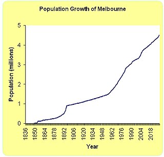
Melbourne is Australia's second largest city and has a diverse and multicultural population.
The Melbourne Sandbelt is a region to the southeast of Melbourne, Australia, known for its sandy soil. Several significant golf courses are located in the region.

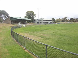
The Murrumbeena Football Club is an Australian rules football club located in the southern suburbs of Melbourne. The club participates in the Southern Football Netball League, based in the south and south eastern suburbs of Melbourne, Victoria. Murrumbeen plays on the historic Peter Robertson Oval, their home ground located along Kangaroo Rd, Murrumbeena.
The Djerring Trail is a shared use path that runs alongside the Cranbourne and Pakenham railway lines in south-eastern Melbourne, Australia. The route serves a total of 13 railway stations.