
The Piccadilly line is a London Underground line that runs between Cockfosters in suburban north London and Acton Town in the west, where it divides into two branches: one of these runs to Heathrow Airport and the other to Uxbridge in northwest London, with some services terminating at Rayners Lane.

Enfield Southgate is a constituency created in 1950 represented in the House of Commons of the UK Parliament since 2017 by Bambos Charalambous, a member of the Labour Party.

Southgate was a local government district of Middlesex from 1881 to 1965. It was part of the London postal district and Metropolitan Police District.

Norbury Brook is a tributary of the River Wandle that rises near Lower Addiscombe Road and flows north-west through Selhurst, Thornton Heath and Norbury to join the Wandle at south Wimbledon.
Croydon North West was a borough constituency represented in the House of Commons of the Parliament of the United Kingdom. It elected one Member of Parliament (MP) by the first past the post system of election.

Bocketts Farm in Surrey, England is a visitor attraction farm set in the countryside on the slopes of the North Downs 1.6 miles (2.6 km) due south of Leatherhead.
Heavers Meadow is a meadow located in South Norwood and Selhurst in the London Borough of Croydon. South Norwood Recreation Ground is on the other side of the road. The meadow covers an area of 83⁄4 acres. With meadows there are not usually many facilities. Heavers is no exception; the only facility stated on the council's website is a footpath through a flood meadow.
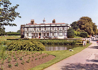
Broomfield House is a building of historical interest located in Broomfield Park, Palmers Green, in the London Borough of Enfield. Built during the 16th century, it was damaged by fires in 1984 and 1994, and is currently awaiting restoration as part of the English Heritage Restoration Programme.

Norbury Park is a swathe of mixed wooded and agricultural land associated with its Georgian manor house near Leatherhead and Dorking, Surrey, which appears in the Domesday Book of 1086. It occupies mostly prominent land reaching into a bend in the Mole and is divided between the parishes of Mickleham and Westhumble. Box Hill, to the south-east, was once part of the estate.

Sandford Manor House is a Grade II* listed house in Rewell Street, Fulham, London.
The Parish Church of Saint Paul is a Church of England parish church in New Southgate, London Borough of Barnet, London.

40 The Green is a grade II listed building on The Green, Southgate, London. The house dates from the early nineteenth century with later alterations. It bears a local blue plaque that reads, "In 1881 this house became the first seat of local government in Southgate", referring to the separation of Southgate from Edmonton in that year.

The Valentine Poole houses are a terrace of grade II listed houses on The Green, Southgate, London. The houses were built in 1780 by the Valentine Poole Trust for the poor of Barnet. The architect was Michael Searles. The buildings were saved from demolition by Southgate Civic Trust and renovated by Peake Estates Limited in 1981.

Oakbeams is a grade II listed house on The Green, Southgate, London. Built in 1929–31, it was designed by architect Paul Badcock for George Cole, a graphic designer and artist's agent. Historic England describe Oakbeams as "an unusually elaborate example of a 'Stockbroker Tudor' inter-war suburban house".

Old House and Essex Coach House are adjoining grade II listed buildings on The Green, Southgate, London.

Arnoside House and Essex House are adjoining grade II* listed buildings on The Green, Southgate, London.
Southgate House is a grade II* listed building in Southgate, London.

Arnos Grove, originally known as Arnolds, is a grade II* listed house in Cannon Hill, London.

The Lion is a former public house on the corner of Barnet Road and Southgate Road in Potters Bar, Hertfordshire, England, and a grade II listed building with Historic England. It became Potty Pancakes some time after 2008.

Beaver Hall was a country house in Middlesex, England. It was set in grounds of around 40 acres (16 ha) that stood to the east and south of the current Waterfall Road, then known as Waterfall Lane and Church Hill, near the old centre of Southgate. The grounds stretched as far south as the Pymmes Brook where Arnos Park was later built. Beaver Hall was acquired by John Walker of the Taylor-Walker brewing family in 1870. The house was demolished in 1871 and the grounds merged into the adjacent Arnos Grove estate.


