This article needs additional citations for verification .(October 2022) |
Sandhill, Belize is a populated settlement located in the nation of Belize. It is a mainland village located in the Belize District.
This article needs additional citations for verification .(October 2022) |
Sandhill, Belize is a populated settlement located in the nation of Belize. It is a mainland village located in the Belize District.
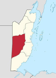
Cayo District is a district located in the west part of Belize. It is the most extensive, second-most populous and third-most densely populated of the six districts of Belize. The district's capital is the town of San Ignacio.

Hattieville is a village in the Belize District of the nation of Belize. It is located at 17N 88W, at an elevation of 196 feet above mean sea level, and has a population of about 1,300 people. Hattieville was established as a refugee camp after Hurricane Hattie made many people homeless in Belize City when it hit in 1961, but it became a permanent town.
Ladyville is the largest village in the country of Belize, eight miles northwest of Belize City in the Belize District. The Philip Goldson Highway connects Ladyville to Belize City.
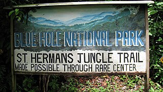
St. Herman's Blue Hole National Park is a national park located just off the Hummingbird Highway in Cayo District of Belize, near Belmopan, the capital city. It is over 500 acres (2 km²) in area, and contains two cave systems, various natural trails, and the cool jungle pool from which the park gets its name. The park is managed by the Belize Audubon Society.
Platón Sánchez Municipality is one of the 212 municipalities of the Mexican state of Veracruz. It is located in the state's Huasteca Alta region. The municipal seat is the town of Platón Sánchez.
Holy Redeemer Primary School is a Catholic, parish primary school located in the heart of Belize City, Belize.

Tacarigua is a town in the East–West Corridor of Trinidad and Tobago, located east of Tunapuna, north of Trincity and west of Arouca. It is on the banks of the Tacarigua River. The city is governed by the Tunapuna–Piarco Regional Corporation.
Pinilla de Toro is a municipality located in the province of Zamora, Castilla y León, Spain. According to the 2004 census (INE), the municipality has a population of 344 inhabitants.
Olivares de Duero is a municipality located in the province of Valladolid, Castile and León, Spain. According to the 2004 census (INE), the municipality has a population of 330 inhabitants.
The Marylebone Cricket Club Grounds is a Belizean football stadium, located on the Northside of Belize City, Belize.

The New River, also Río Nuevo, is a river in northern Belize. As the longest river that is entirely confined to Belize, it drains primarily the eastern part of the Orange Walk District during its north-northeasterly course and empties into the Chetumal Bay. The river also forms the New River Lagoon, the largest body of fresh water in Belize, just east of the Maya temples of Lamanai. The New River is a habitat for numerous types of fish, birds, as well as crocodiles.
Yargo is the name of several villages in Burkina Faso, including the following:
The Belmopan Public Library located on Mot Mot Ln, Belmopan, the capital city of Belize, was inaugurated on August 24, 1970. The process of constructing a local library began after Hurricane Hattie, in 1961, devastated the previous capital, Belize City, located on the east coast of Belize. In the wake of this destruction the government of Belize agreed to relocate the capital further inland and it was during this time in 1961 that Belmopan was constructed from nothing but a thinly populated area of preserved bush otherwise known as jungle. During the construction of the new capital the local residents identified a need for a public library and the British Overseas Development Mission approved the funding of the Belmopan Public Library. The Honorable Santiago Perdomo, Ministry of Education, and Leo Bradley, Chief Librarian finally inaugurated the building in 1971 and the same building has been the location of the Belmopan Public Library for the last 41 years.
The Maritime Museum is a museum in Belize City, Belize. The museum is located at the North Front St, Marine Terminal at Swing Bridge in the former fire station. The museum opened in 1996.
Maskall is a settlement located in the nation of Belize. It is a mainland village located in Belize District. It is 39 miles north of Belize City.
Yarborough Cemetery is an historical cemetery located in Belize City, Belize. It was the first cemetery in British Honduras, used from 1787 until 1896, and was established for the burial of members of the colonial Anglican Church. It was named after the magistrate who owned the land. The cemetery was renovated in 1999 with the addition of perimeter fencing, landscaping and a marble memorial wall highlighting the names and contributions of those buried there. In 2009, the government designated it an archaeological reserve.
The National Archives of Belize are the national archives of Belize. They are located in Belmopan.
Corozal Bay is an inlet of Chetumal Bay, indenting northern Belize. Several resort areas are located on the coast of the bay, most notably Corozal Town. The New River (Belize) flows north into the bay. The town of Consejo is located north-northeast of the bay, on the much larger Chetumal Bay. The Mayan ruins of Cerros are located on the bay.
The Mayflower Bocawina National Park is a national park in Belize that was established in 2001. This national park boasts a vast quantity of flora and fauna. The Mayflower Bocawina National Park is managed by the Friends of Mayflower Bocawina National Park and is listed as Category 2 on the IUCN list.
Seine Bight is a village on the Placencia Peninsula located in the Stann Creek District of Belize. It is located 2 and a half miles south of Maya Beach Village and North of the village of Placencia. This small village has roughly 1,000 inhabitants, mostly Garifuna people who subsist on fishing, hunting, and homegrown vegetables. The early settlers named their village for their favored fishing tackle, Seine fishing and a bight, a bend or curve in a coastline.
| | This article about the geography of Belize is a stub. You can help Wikipedia by expanding it. |