
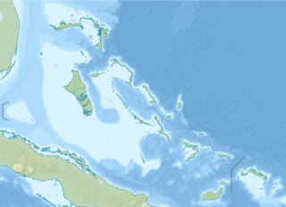
Andros Island is an archipelago within the Bahamas, the largest of the Bahamian Islands. Politically considered a single island, Andros in total has an area greater than all the other 700 Bahamian islands combined. The land area of Andros consists of hundreds of small islets and cays connected by mangrove estuaries and tidal swamplands, together with three major islands: North Andros, Mangrove Cay, and South Andros. The three main islands are separated by "bights", estuaries that trifurcate the island, connecting the island's east and west coasts. It is 167 kilometres (104 mi) long by 64 km (40 mi) wide at the widest point.

Fresh Creek was a district of the Bahamas before 1996. It consisted of the central portion of the island of Andros. The population (1995) was 2,576.

South Andros is a district of the nation of the Bahamas.

Bill Baggs Cape Florida State Recreation Area occupies approximately the southern third of the island of Key Biscayne, at coordinates 25°40′25″N80°09′34″W. This park includes the Cape Florida Light, the oldest standing structure in Greater Miami. In 2005, it was ranked as having the 8th best beach in the country, and in 2013 Forbes ranked it at 7th.

Mangrove Cay is one of the districts of the Bahamas, on Andros Island. Its capital is Moxey Town in the north east corner of the island.

North Andros is one of the 31 districts of the Bahamas. It is also the largest district in the country. It has some of the largest settlements on Andros Island and many churches as well. The population is 3,898.
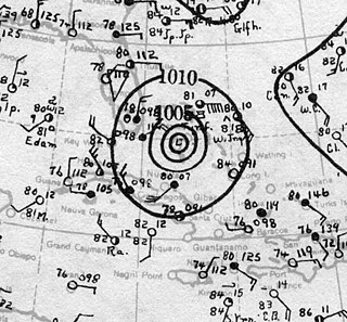
The 1929 Bahamas hurricane was a high-end Category 4 tropical cyclone whose intensity and slow forward speed led to catastrophic damage in the Bahamas in September 1929, particularly on Andros and New Providence islands. Its erratic path and a lack of nearby weather observations made the hurricane difficult to locate and forecast. The storm later made two landfalls in Florida, killing eleven but causing comparatively light damage. Moisture from the storm led to extensive flooding over the Southeastern United States, particularly along the Savannah River. Across its path from the Bahamas to the mouth of the Saint Lawrence River, the hurricane killed 155 people.
Lynx Air International was a United States airline based in Fort Lauderdale, Florida, USA.

Nicholls Town is a town located in North Andros, part of Andros island in the Bahamas. The town features a sweeping beachfront.
Andros Town Airport or Andros Town International Airport is an airport serving Andros Town on Andros Island in the Bahamas. It is also known as Fresh Creek Airport.

The following outline is provided as an overview of and topical guide to The Bahamas:

The following is an alphabetical list of topics related to the Commonwealth of The Bahamas.
Andros Town is a town in North Andros and capital of Andros Island in the Bahamas.
The Deep Creek is a tidal creek in North Andros, the Bahamas.
The Loggerhead Creek is a tidal stream in North Andros the Bahamas.
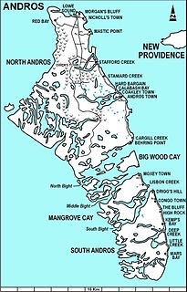
The Staniard Creek is a tidal creek in North Andros, the Bahamas.
Stafford Creek is a town on North Andros Island in the Bahamas. It is about 3 miles (4.8 km) north of Staniard Creek and about 40 miles (64 km) west of Nassau and about 160 miles (260 km) southeast of Miami. It has a population of 98.
Andros Conservancy & Trust Bahamas (ANCAT) is an environmental nonprofit non-governmental organisation (NGO) dedicated to preserving the natural resources of Andros Island, the Bahamas. Founded in 1999, among its key accomplishment was the 2002 formation of the 286,000 acre Central Andros National Park, in co-operation with the Bahamas National Trust, a division of the Bahamian government.
West Side National Park is a national park covering the western half of Andros, the Bahamas, and the surrounding waters. The park was established in 2002 and, after being expanded in 2012, has an area of 1,500,000 acres (6,070 km2), being one of the largest protected areas in the region. The park is regarded as a marine protected area, which includes tidal creeks and coastal mangrove forest, as well as an expansive coastal zone.
