Sandy Ground, Saint Martin

Last updated
Sandy Ground
Sol Sableux
Saint-Martin collectivity location map.svg
Red pog.svg
Sandy Ground
Coordinates: 18°03′32″N63°05′49″W / 18.05889°N 63.09694°W / 18.05889; -63.09694
CountryFrance
Overseas collectivity Saint Martin

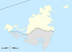
Sandy Ground (French : Sol Sableux) is a coastal community on the French side of the Caribbean island of Saint Martin/Saint Maarten.

Contents

Sandy Ground is known for its luxury hotels, [1] nature, and beaches. [2]

Geography

It is located on the west coast in the direction of the Lowlands and the Princess Juliana International Airport.

Hurricane Irma

Sandy Ground sustained heavy damage to its infrastructure. This Category 5 hurricane made landfall on the island in September 2017, causing $156 million in damage and killing 15 people. [3]

Related Research Articles

<span class="mw-page-title-main">Anguilla</span> British Overseas Territory in the Leeward Islands

Anguilla is a British Overseas Territory in the Caribbean. It is one of the most northerly of the Leeward Islands in the Lesser Antilles, lying east of Puerto Rico and the Virgin Islands and directly north of Saint Martin. The territory consists of the main island of Anguilla, approximately 16 miles long by 3 miles (5 km) wide at its widest point, together with a number of much smaller islands and cays with no permanent population. The territory's capital is The Valley. The total land area of the territory is 35 square miles (91 km2), with a population of approximately 15,753 (2021).

<span class="mw-page-title-main">Nevis</span> Island in the Caribbean Sea

Nevis is a small island in the Caribbean Sea that forms part of the inner arc of the Leeward Islands chain of the West Indies. Nevis and the neighbouring island of Saint Kitts constitute the Federation of Saint Kitts and Nevis, a singular nation state. Nevis is located near the northern end of the Lesser Antilles archipelago about 350 kilometres (220 mi) east-southeast of Puerto Rico and 80 kilometres (50 mi) west of Antigua. Its area is 93 square kilometres (36 sq mi) and the capital is Charlestown.

<span class="mw-page-title-main">History of Saint Kitts and Nevis</span> Aspect of history

Saint Kitts and Nevis have one of the longest written histories in the Caribbean, both islands being among Spain's and England's first colonies in the archipelago. Despite being only two miles apart and quite diminutive in size, Saint Kitts and Nevis were widely recognized as being separate entities with distinct identities until they were forcibly united in the late 19th century.

<span class="mw-page-title-main">Geography of Anguilla</span> Geography of the British Overseas Territory of Anguilla

Anguilla is an island in the Leeward Islands. It has numerous bays, including Barnes, Little, Rendezvous, Shoal, and Road Bays.

<span class="mw-page-title-main">Economy of Anguilla</span>

The economy of Anguilla depends heavily on luxury tourism, offshore banking, lobster fishing, and remittances from emigrants. Due to its small size, few natural resources, and reliance on tourism and foreign direct investment, Anguilla is vulnerable to external economic conditions in the United States, Canada and Europe. Therefore, economic growth in Anguilla can be very volatile.

<span class="mw-page-title-main">Saint Martin (island)</span> Small island in the Caribbean

Saint Martin is an island in the northeast Caribbean Sea, approximately 300 km (190 mi) east of Puerto Rico. The 87 square kilometres (34 sq mi) island is divided roughly 60:40 between the French Republic and the Kingdom of the Netherlands, but the Dutch part is more populated than the French part. The division dates to 1648. The northern French part comprises the Collectivity of Saint Martin and is an overseas collectivity of the French Republic. As part of France, the French part of the island is also part of the European Union. The southern Dutch part comprises Sint Maarten and is one of four constituent countries that form the Kingdom of the Netherlands.

<span class="mw-page-title-main">Hurricane Lenny</span> Category 4 Atlantic hurricane in 1999

Hurricane Lenny was the strongest November Atlantic hurricane since the 1932 Cuba hurricane. It was the twelfth tropical storm, eighth hurricane, and record-breaking fifth Category 4 hurricane in the 1999 Atlantic hurricane season. Lenny formed on November 13 in the western Caribbean Sea at around 18:00 UTC and went on to form and maintain an unusual and unprecedented easterly track for its entire duration, which gave it the common nickname, "Wrong Way Lenny." It attained hurricane status south of Jamaica on November 15 and passed south of Hispaniola and Puerto Rico over the next few days. Lenny rapidly intensified over the northeastern Caribbean on November 17, attaining peak winds of 155 mph (249 km/h) about 21 mi (34 km) south of Saint Croix in the United States Virgin Islands. It gradually weakened while moving through the Leeward Islands, eventually dissipating on November 23 over the open Atlantic Ocean.

<span class="mw-page-title-main">Hurricane Luis</span> Category 4 Atlantic hurricane in 1995

Hurricane Luis was a long lived and powerful Category 4 hurricane. It was the strongest hurricane to make landfall and the third-most intense hurricane recorded during the 1995 Atlantic hurricane season. The storm, along with Humberto, Iris, and Karen, was one of four simultaneous tropical systems in the Atlantic basin.

<span class="mw-page-title-main">Princess Juliana International Airport</span> Airport on the Caribbean island of Saint Martin, Sint Maarten

Princess Juliana International Airport is the main airport on the Caribbean island of Saint Martin. The airport is located on the Dutch side of the island, in the country of Sint Maarten, close to the shore of Simpson Bay Lagoon. In 2015, the airport handled 1,829,543 passengers and around 60,000 aircraft movements. The airport serves as a hub for Winair and is the major gateway for the smaller Leeward Islands, including Anguilla, Saba, Saint Barthélemy and Sint Eustatius. It is named after Queen Juliana of the Netherlands, who landed there while she was heir presumptive in 1944, the year after the airport opened. The airport has very low-altitude flyover landing approaches because one end of its runway is extremely close to the shore and Maho Beach. While Princess Juliana International is the primary aviation gateway to the island, there is also a smaller public-use airport on the French side, in the French Collectivity of Saint Martin, called Grand Case-Espérance Airport.

<span class="mw-page-title-main">Seven Mile Beach, Grand Cayman</span>

Seven Mile Beach (SMB) is a long crescent of coral-sand beach on the western end of Grand Cayman island. Seven Mile Beach is known for its beauty, receiving the honor of "The Caribbean's Best Beach" in 2015 from Caribbean Travel and Life Magazine. It is public property and one is able to walk the full length of the beach, regardless of where you are staying. The Seven Mile Beach is the most popular and most developed area of Grand Cayman. It is home to the majority of the island's luxury resorts and hotels. Despite the name, a generous measurement puts the actual length at just a bit over 6.3 miles (10.1 km) long. A realistic length for the uninterrupted sandy beach is about 6 miles. The beach falls victim to annual erosion, which has reduced its size in some areas, and may have reduced its length at the ends. Like the rest of Grand Cayman, the development around the Seven Mile Beach was severely damaged in Hurricane Ivan in September 2004 but many condominiums & hotels are still running at full capacity.

<span class="mw-page-title-main">Hurricane Klaus (1984)</span> Category 1 Atlantic hurricane in 1984

Hurricane Klaus was a North Atlantic hurricane that hit the Leeward Islands from the west in November of the 1984 Atlantic hurricane season. Forming from a broad area of low pressure on November 5, Klaus maintained a northeast movement throughout much of its path. After making landfall on extreme eastern Puerto Rico, it passed to the north of the Leeward Islands, resulting in strong southwesterly winds and rough seas. Klaus attained hurricane status and reached peak winds of 90 mph (145 km/h) before becoming extratropical over cooler waters on November 13. The storm dropped heavy rainfall in Puerto Rico, causing minor flooding and light damage. Klaus caused heavy marine damage in the Leeward Islands, including wrecking at least three ships. The Virgin Islands experienced heavy damage as well.

<span class="mw-page-title-main">Collectivity of Saint Martin</span> French overseas collectivity, part of the island of Saint Martin in the Lesser Antilles

The Collectivity of Saint Martin, commonly known as simply Saint Martin, is an overseas collectivity of France in the West Indies in the Caribbean, on the northern half of the island of Saint Martin, as well as some smaller adjacent islands. Saint Martin is separated from the island of Anguilla by the Anguilla Channel. Its capital is Marigot.

<span class="mw-page-title-main">Sint Maarten</span> Country on the Caribbean island of Saint Martin, part of the Kingdom of the Netherlands

Sint Maarten is a constituent country of the Kingdom of the Netherlands in the Caribbean. With a population of 41,486 as of January 2019 on an area of 34 km2 (13 sq mi), it encompasses the southern 44% of the divided island of Saint Martin, while the northern 56% of the island constitutes the French overseas collectivity of Saint Martin. Sint Maarten's capital is Philipsburg. Collectively, Sint Maarten and the other Dutch islands in the Caribbean are often called the Dutch Caribbean.

<span class="mw-page-title-main">Saint Barthélemy</span> French island in the Caribbean

Saint Barthélemy, officially the Collectivité territoriale de Saint-Barthélemy, also known as St. Barts (English) or St. Barth (French), is an overseas collectivity of France in the Caribbean. The island lies about 30 kilometres (19 mi) southeast of the island of Saint Martin; it is northeast of the Dutch islands of Saba and Sint Eustatius, as well as north of the independent country of Saint Kitts and Nevis.

<span class="mw-page-title-main">Economy of Saint Martin (island)</span>

The economy of Saint Martin, divided between the French Collectivity of Saint Martin and the Dutch Sint Maarten, is predominately dependent on tourism. For more than two centuries, the main commodity exports have generally been salt and locally grown commodities, like sugar.

Grand Case is a small town on the French side of the island of Saint Martin in the Caribbean. It lies on the Anguilla Channel, on the west coast of the island. Grand Case has a long sandy beach. It is well known for its many restaurants and beach bars. It is the most populous place of the French Saint Martin.

La Samanna, A Belmond Hotel, St Martin is a Caribbean luxury resort, located on the half-French, half-Dutch island of Saint Martin in the French West Indies. It overlooks Baie Longue, one of the island’s longest and most secluded beaches.

Eden Rock, St Barths is a luxury resort in Saint Barthélemy in the Caribbean, jutting out on a craggy quartzite bluff overlooking the Baie de Saint Jean on the central north coast. The resort is very popular with the rich and famous. U.S. News Travel ranks it as the best hotel on the island, and was included in Travel and Leisure's 500 World's Best Hotels for 2015.

<span class="mw-page-title-main">Sandy Island, Anguilla</span>

Sandy Island is an island in Anguilla, a British Overseas Territory, and is part of the Lesser Antilles in the Caribbean Sea.

<span class="mw-page-title-main">Hurricane Irma</span> Category 5 Atlantic hurricane in 2017

Hurricane Irma was an extremely powerful Cape Verde hurricane that caused widespread destruction across its path in September 2017. Irma was the first Category 5 hurricane to strike the Leeward Islands on record, followed by Maria two weeks later. At the time, it was considered the most powerful hurricane on record in the open Atlantic region, outside of the Caribbean Sea and Gulf of Mexico, until it was surpassed by Hurricane Dorian two years later. It was also the third-strongest Atlantic hurricane at landfall ever recorded, just behind the 1935 Labor Day Hurricane and Dorian.

References

  1. "Top 10 Hotels in Sandy Ground, St. Martin | Hotels.com". www.hotels.com. Retrieved 2018-09-25.
  2. "Anguilla Beaches Walk... Sandy Ground Beach and Village". anguilla beaches. Retrieved 2018-09-05.
  3. Dobson, Jim. "Hurricanes Irma And Maria Update: Caribbean Luxury Resort Damage Reports". Forbes. Retrieved 2018-09-05.