
Oregon City is the county seat of Clackamas County, Oregon, United States, located on the Willamette River near the southern limits of the Portland metropolitan area. Established in 1829 by the Hudson's Bay Company, in 1844 it became the first U.S. city west of the Rocky Mountains to be incorporated.

Nauvoo is a small city in Hancock County, Illinois, United States, on the Mississippi River near Fort Madison, Iowa. The population of Nauvoo was 1,149 at the 2010 census. Nauvoo attracts visitors for its historic importance and its religious significance to members of several groups: The Church of Jesus Christ of Latter-day Saints ; the Community of Christ, formerly the Reorganized Church of Jesus Christ of Latter Day Saints (RLDS); other groups stemming from the Latter Day Saint movement; and the Icarians. The city and its immediate surrounding area are listed on the National Register of Historic Places as the Nauvoo Historic District.

South Bend is a city in, and the county seat of, St. Joseph County, Indiana, on the St. Joseph River near its southernmost bend, from which it derives its name. As of the 2010 census, the city had a total of 101,168 residents; its metropolitan statistical area had a population of 318,586 and its combined statistical area, 721,296. It is the fourth-largest city in Indiana, serving as the economic and cultural hub of northern Indiana.
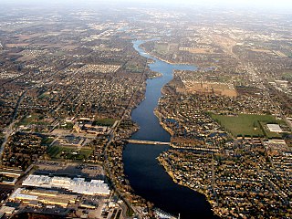
The St. Joseph River is a 206 miles (332 km) long tributary of Lake Michigan flowing generally westerly through southern Michigan and northern Indiana, United States, to its terminus on the southeast shore of the lake. It drains a primarily rural farming area in the watershed of Lake Michigan. It was enormously important to Native Americans and greatly aided in the colonial exploration, settlement and administration of New France and the nascent United States as a canoe route between Lake Michigan and the watershed of the Mississippi River.

Pocket-Greenhaven is a suburban community within the city of Sacramento, California, 5 miles south of downtown Sacramento. It is bordered by Interstate 5 on the east and a semi-circular "pocket" bend in the Sacramento River on the south, west, and north. The three exits into the Pocket-Greenhaven community off Interstate 5 are 43rd Avenue, Florin Road, and Pocket/Meadowview Road. Entering the area from the South on Interstate 5, travelers pass a landmark water tower with the words "Welcome to SACRAMENTO AMERICA'S FARM-TO-FORK CAPITAL" painted on it, marking the southern boundary of the city of Sacramento. Pocket-Greenhaven is located in the 95831 Zip code.
The city of Minneapolis, Minnesota, United States is officially defined by the Minneapolis City Council as divided into eleven communities, each containing multiple official neighborhoods. Informally, there are city areas with colloquial labels. Residents may also group themselves by their city street suffixes, North, Northeast, South, Southeast, and Southwest.
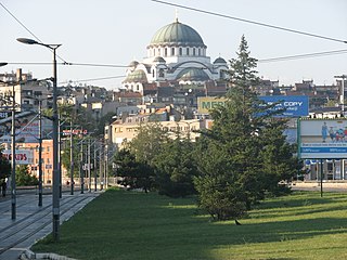
Vračar is a municipality of the city of Belgrade. According to the 2011 census results, the municipality has a population of 56,333 inhabitants.

Swisshelm Park is a neighborhood located in the southeast corner of Pittsburgh, Pennsylvania. It is represented on Pittsburgh City Council by Corey O'Connor. Swisshelm Park houses PBF 19 Engine, and is covered by PBP Zone 4 and the Bureau of EMS Medic 7.

Bridesburg, the northernmost of Philadelphia's River Wards, is a river-front neighborhood in the Northeast section of Philadelphia, Pennsylvania, United States. Bridesburg is an historically German and Irish community, with a significant community of Polish immigrants who arrived mostly in the early- to mid-twentieth century. The community is home to two Catholic churches: All Saints Church, designed by Edwin Forrest Durang, built in 1889; and Saint John Cantius Church, built some time after 1892 in Polish Cathedral style.
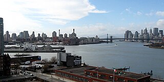
Wallabout Bay is a small body of water in Upper New York Bay along the northwest shore of the New York City borough of Brooklyn, between the present Williamsburg and Manhattan Bridges. It is located opposite Corlear's Hook in Manhattan, across the East River to the west. Wallabout Bay is now the site of the Brooklyn Navy Yard.

Humber Heights-Westmount, also known as Humbervale, is a neighbourhood in Etobicoke, Toronto, Ontario. The neighbourhood is bounded by the west bank of the Humber River, west to Royal York Road and south to Eglinton Avenue West. The Humber Creek divides the area into the northern 'Humber Heights' and the southern 'Westmount' centred along Scarlett Road and La Rose Avenue.

There are more than 500 neighborhoods within the area of Jacksonville, Florida, the largest city in the contiguous United States by area. These include Downtown Jacksonville and surrounding neighborhoods. Additionally, greater Jacksonville is traditionally divided into several major sections with amorphous boundaries: Northside, Westside, Southside, and Arlington, as well as the Jacksonville Beaches.

Ouiatenon was a dwelling place of members of the Wea tribe of Native Americans. The name Ouiatenon, also variously given as Ouiatanon, Oujatanon, Ouiatano or other similar forms, is a French rendering of a term from the Wea dialect of the Miami-Illinois language which means "place of the people of the whirlpool", an ethnonym for the Wea. Ouiatenon can be said to refer generally to any settlement of Wea or to their tribal lands as a whole, though the name is most frequently used to refer to a group of extinct settlements situated together along the Wabash River in what is now western Tippecanoe County, Indiana.
The Indian diaspora in Southeast Africa consists of approximately 3 million people of Indian origin. Most of this diaspora in Southeast Africa arrived in the 19th century as British indentured labourers, many of them to work on the Kenya–Uganda railway. Others had arrived earlier by sea as traders.

Several neighborhoods of Norwich, Connecticut maintain independent identities and are recognized by official signs marking their boundaries. The following is a list of neighborhoods in Norwich.

College Hill is a neighborhood of the City of St. Louis, Missouri. The name College Hill was given to this area because it was the location of the Saint Louis University College Farm. This area, bounded generally by Warne Ave., O'Fallon Park, I-70, Grand Boulevard, and W. Florissant Ave., was acquired by the University for garden and recreation purposes in 1836. It was subdivided in the early 1870s.

Throughout its history, Toronto has been a city divided into many districts and neighbourhoods. As the city has grown, new neighbourhoods have been created by expansion of the city into the countryside. Over time, the neighbourhoods within existing areas have also been altered and rearranged.
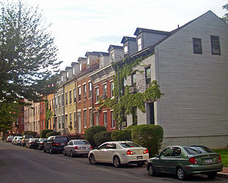
The Pastures Historic District is a residential neighborhood located south of downtown Albany, New York, United States. Its 17 acres (6.9 ha) include all or part of a 13-block area.
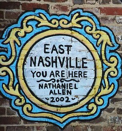
East Nashville is an area east of downtown Nashville in Tennessee across the Cumberland River. The area is mostly residential and mixed-use areas with businesses lining the main boulevards. The main thoroughfare is Gallatin Avenue and Ellington Parkway with smaller arteries interconnecting the neighborhoods. Some of these smaller arteries include Main Street, Shelby Avenue, Porter Road, Riverside Drive, Eastland Avenue, McFerrrin Avenue, and Woodland Street in no significant order. Ellington Parkway, which parallels Gallatin Avenue and Main Street, bypasses I-24 and I-65 and connects Briley Parkway and downtown Nashville and many other secondary streets along the way. The Cumberland River confines most of the area with a semicircle design on the south, southwest and east. Since East Nashville has no defined boundaries on the west and north the exact perimeter is the cause of some debate. Some would say that Ellington Parkway creates a boundary on the west and northwest, while Cahal Avenue and Porter Road in the north, in the confines of zipcode 37206. Many would now state that I-65 and I-24 create the western border and Briley Parkway as the northern boundary, which is called Greater East Nashville.
Aghavoher is a townland in the civil parish of Tomregan, County Cavan, Ireland. It lies in the former barony of Loughtee Lower.