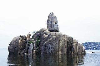
Mwanza City, also known as Rock City to the residents, is a port city and capital of Mwanza Region on the southern shore of Lake Victoria in north-western Tanzania. With an urban population of 1,311,000 in 2023, it is Tanzania's second largest city, after Dar es Salaam. It is also the second largest city in the Lake Victoria basin after Kampala, Uganda and ahead of Kisumu, Kenya at least in population size. Within the East African community, Mwanza city is the fifth largest city after Dar, Nairobi, Mombasa, and Kampala. It is slightly ahead of Kigali, Kisumu, and Bujumbura in the population of city proper limits. Mwanza city is also the capital city of Mwanza Region, and is administratively divided into two municipal districts within that Region - Ilemela and Nyamagana.

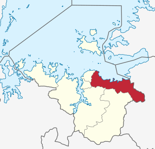
Mwanza Region is one of Tanzania's 31 administrative regions, covering a total land area of 25,233 km2 (9,743 sq mi). The region is comparable in size to the combined land area of the nation state of North Macedonia. Mwanza Region is bordered to the north through Lake Victoria by the Kagera Region and Mara Region, to the east by Simiyu Region, to the south by the Shinyanga Region and to the west by Geita Region. The regional capital is the city of Mwanza. According to the 2022 national census, the region had a population of 3,699,872 and national census of 2012 had 2,772,509. Mwanza Region is the second region with high population in Tanzania after Dar es Salaam Region.
Magu District is one of the seven districts of the Mwanza Region of Tanzania, East Africa. Its administrative centre is the town of Magu on the Simiyu River. It is bordered to the north by Lake Victoria and Busega District, to the east by Bariadi District, to the south by Itilima District, Maswa District, Kwimba District and Misungwi District, and to the west by the city of Mwanza, which consists of Nyamagana District and Ilemela District.

Nyamagana District is one of the eight districts of the Mwanza Region of Tanzania. It is bordered to the north by Ilemela District, to the east by Magu District, to the south by Misungwi District and to the west by the Mwanza Bay of Lake Victoria. The region's capital, the City of Mwanza, is within Nyamagana District. The district commission's office is scheduled to be re-located to the Mkolani area of Mwanza town, but currently it is still in the old city hall in the centre of town.

Ilemela District is one of the seven districts of the Mwanza Region of Tanzania with a postcode number 33200. It is bordered to the north and west by Lake Victoria, to the east by Magu District, and to the south by Nyamagana District. Part of the region's capital, the town of Mwanza, is within Ilemela District. The district commission's office is located in Buswelu area of Mwanza town.
Bugogwa is an administrative ward in Ilemela District, Mwanza Region, Tanzania with a postcode number 33207. In 2016 the Tanzania National Bureau of Statistics report there were 32,925 people in the ward, from 37,312 in 2012.
Buswelu is an administrative ward in Ilemela District in Mwanza Region, Tanzania with a postcode number 33204. In 2016 the Tanzania National Bureau of Statistics report there were 18,363 people in the ward, from 22,897 in 2012.
Buzuruga is an Ward in Ilemela District, Mwanza Region, Tanzania with a postcode number 33213. In 2016 the Tanzania National Bureau of Statistics report there were 22,410 people in the ward.
Ilemela is an Ward and the headquarter of the Ilemela District in the Mwanza Region of Tanzania with a postcode number 33205. In 2016 the Tanzania National Bureau of Statistics report there were 25,240 people in the ward, from 43,244 in 2012.
Kawekamo, also known as Kamwekamo, is an Administrative Ward and the headquarter of the Ilemela District in Mwanza Region Tanzania. In 2016 the Tanzania National Bureau of Statistics report there were 22,526 people in the ward.
Kayenze is an administrative ward in Ilemela District, Mwanza Region, Tanzania. In 2016 the Tanzania National Bureau of Statistics report there were 10,035 people in the ward.
Kurumba is an administrative ward in Ilemela District, Mwanza Region, Tanzania. In 2016 the Tanzania National Bureau of Statistics report there were 31,656 people in the ward, from 28,103 in 2012.
Kitangiri is an administrative ward in Ilemela District, Mwanza Region, Tanzania. In 2002, the ward had a total population of 14,282 according to the national Census of 2002 this was before split from Nyamagana District on 1 October 2012 as Ilemela becomes a District Council where given total of 20 wards. In 2016 the Tanzania National Bureau of Statistics report there were 23,432 people in the ward, from 20,802 in 2012.
Mecco is an administrative ward in Ilemela District, Mwanza Region, Tanzania. In 2016 the Tanzania National Bureau of Statistics report there were 15,746 people in the ward.
Nyakato is an administrative Ward in Ilemela District, Mwanza Region, Tanzania. In 2016 the Tanzania National Bureau of Statistics report there were 127,736 people in the ward, from 82,348 in 2012 when Nyamagana District split.
Nyamanoro is an administrative ward in Ilemela District, Mwanza Region, Tanzania. In 2016 the Tanzania National Bureau of Statistics report there were 27,010 people in the ward, from 51,456 in 2012 when Nyamagana District split.
Nyasaka is an administrative ward in Ilemela District, Mwanza Region, Tanzania with a postcode number 33214. In the national census of 2002, the ward had a total population of 27,356. This was before the split from Nyamagana District on 1 October 2012, when Ilemela became a District Council with a total of 20 wards and in the National Census of 2012, the district had a population of 265,911.
Pasiansi is an Ward in Ilemela District, Mwanza Region, Tanzania with a postcode 33206. In 2016 the Tanzania National Bureau of Statistics report there were 17,713 people in the ward, from 35,723 in 2012.
Kiseke is an administrative ward in Ilemela District, Mwanza Region, Tanzania with a postcode number 33216.
Kahama is an administrative ward in Ilemela District, Mwanza Region, Tanzania. In the year 2016, the Tanzania National Bureau of Statistics reported that there were 8,197 people in the ward. Its post code is 33215.
