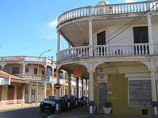
Antsiranana, named Diego-Suarez prior to 1975, is a city in the far north of Madagascar.

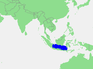
The Java Sea is an extensive shallow sea on the Sunda Shelf. It lies between the Indonesian islands of Borneo to the north, Java to the south, Sumatra to the west, and Sulawesi to the east. Karimata Strait to its northwest links it to the South China Sea.

The Savu Sea is a small sea within Indonesia named for the island of Savu (Sawu) on its southern boundary. It is bounded by Savu and Rai Jua to the south, the islands of Rote and Timor to the east, Flores and the Alor archipelago to the north/northwest, and the island of Sumba to the west/northwest. Between these islands, it flows into the Indian Ocean to the south and west, the Flores Sea to the north, and the Banda Sea to the northeast.

The Flores Sea covers 240,000 square kilometres (93,000 sq mi) of water in Indonesia. The sea is bounded on the north by the island of Celebes and on the south by Sunda Islands of Flores and Sumbawa.

Godthul is a bay 1 mile (1.6 km) long entered between Cape George and Long Point, on the north coast of South Georgia, between Cumberland East Bay and Ocean Harbour. Szielasko Ice Cap sits on the south edge of the harbor. The name Godthul dates back to the period 1905–12, and was probably applied by Norwegian sealers and whalers working in the area.
Sanggar Mustika is the eighth studio album from Malaysian pop singer Siti Nurhaliza released in 2002.

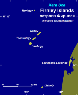
The Firnley Islands is a group of three small islands covered with tundra vegetation and with scattered stones on their shores. They lie in the Kara Sea, close to the bleak coast of Siberia's Taymyr Peninsula, not far east of the Nordenskjold Archipelago. These islands lie about 35 km from the continental shore.
The Kugaryuak River is located in the Canadian Arctic territory of Nunavut in the southwest Kitikmeot Region. It forks into two entities, the Western Kugaryuak and the Eastern Kugaryuak and flows into Coronation Gulf.

Zdziechowice is a village in the administrative district of Gmina Środa Wielkopolska, within Środa Wielkopolska County, Greater Poland Voivodeship, in west-central Poland. It lies approximately 8 kilometres (5 mi) north of Środa Wielkopolska and 28 km (17 mi) south-east of the regional capital Poznań.

Dibble Glacier in Antarctica is a prominent channel glacier flowing from the continental ice and terminating in a prominent tongue at the east side of Davis Bay. It was delineated from air photos taken by U.S. Navy Operation Highjump (1946–47), and named by the Advisory Committee on Antarctic Names for Jonas Dibble, ship's carpenter on the sloop Peacock of the United States Exploring Expedition (1838–42) under Charles Wilkes. Dibble is credited with leaving his sick bed and working 24 hours without relief with other carpenters to repair a broken rudder on the Peacock, when the ship was partially crushed in an ice bay in 151°19′E and forced to retire northward.

Rostki Bajtkowskie is a village in the administrative district of Gmina Ełk, within Ełk County, Warmian-Masurian Voivodeship, in northern Poland. It lies approximately 8 kilometres (5 mi) south-west of Ełk and 118 km (73 mi) east of the regional capital Olsztyn.

Bima Regency is a regency of the Indonesian Province of West Nusa Tenggara. It is located on the island of Sumbawa and the capital is Woha. The Regency covers an area of 4,389.40 km2, and had a population of 438,522 at the 2010 Census; the latest official estimate is 458,961. It excludes but completely surrounds Bima City (Kota).

Dompu Regency is a regency of the Indonesian Province of West Nusa Tenggara. It is located on the island of Sumbawa and the capital is Dompu. It is bordered to the north and to the east by two non-contiguous parts of Bima Regency, as well as by Saleh Bay, Sanggar Bay, and Cempi Bay. It covers an area of 2,321.55 km2, and the population at the 2010 Census was 218,984; the latest official estimate is 228,811.

Saleh Bay is the largest bay in the island of Sumbawa, Indonesia, roughly on the north central part. It is semi enclosed by Moyo Island and the peninsula of Tambora, Sanggar Peninsula. 3 larger islands in the bay are Liang Island, Ngali Island, and Rakit Island. 3 of the 4 regencies of Sumbawa border the bay.
Cempi Bay or Cempi Gulf is a bay which borders the southern part of Dompu Regency of Sumbawa island facing the Indian Ocean. It is notable for having a surfing enthusiast spots of Hu'u and Lakey Beach.
Ekblad Glacier is a glacier, 8 nautical miles (15 km) long, flowing from the eastern slopes of the Holland Range into Wise Bay, Ross Ice Shelf. It was named by the Advisory Committee on Antarctic Names for A. Ekblad, Master of the USNS Wyandot during U.S. Navy Operation Deepfreeze, 1964 and 1965.
Markham Bay is a bay 8 nautical miles (15 km) wide, lying between Ekelöf Point and Hamilton Point on the east side of James Ross Island, Antarctica. It was possibly first seen by a British expedition under James Clark Ross, who explored this area in 1842–43, but was first charted by the Swedish Antarctic Expedition, 1901–04, under Otto Nordenskjöld, who named it for Sir Clements Markham.
The Bima language, or Bimanese is an Austronesian language spoken on the eastern half of Sumbawa Island, Indonesia, which it shares with speakers of the Sumbawa language. Bima territory includes the Sanggar Peninsula, where the extinct Papuan language Tambora was once spoken. "Bima" is an exonym; the autochthonous name for the territory is "Mbojo" and the language is referred to as "Nggahi Mbojo." There are over half a million Bima speakers. Neither the Bima nor the Sumbawa people have alphabets of their own for they use the alphabets of the Bugis and the Malay language indifferently.

Manipa Island is an island in West Seram Regency, Maluku Province, Indonesia. It is located 8 km off the western coast of Kelang at the western end of Seram Island and 25 km off the western coast of Buru. The inhabitants speak the Manipa language, as well as Indonesian and Ambonese Malay.

Sanggar Agung Temple or Hong San Tang is a Chinese temple in Surabaya dedicated to Chinese deities and other Asian religious icons. It is located within the Pantai Ria amusement park and become a tourist destination, even though it is originally a worship place for Tridharma followers. The name of Sanggar Agung is derived from Indonesian language which can be translated as Great Hall.


