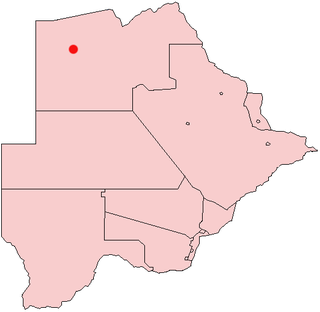
Tubu is a village in North-West District of Botswana, 10 kilometers due east of Gumare village. It is located close to the Okavango Delta, it has a primary school, a clinic and electricity. The population was 392 in 2001 census.

Gumare or Gomare is a rural village located in the North-West District of Botswana, near the Okavango Delta. The population of Gumare was 6,067 in 2001 census, but had risen to 8,532 iby the 2011 census.

Kasane is a town in Botswana, close to Africa's 'Four Corners', where four countries almost meet: Botswana, Namibia, Zambia and Zimbabwe. It is at the far north-eastern corner of Botswana where it serves as the administrative center of the Chobe District. The population of Kasane was 7,638 in 2001 census.

Shakawe is a village located in the northwest corner of Botswana at the beginning of the Okavango Delta, close to Namibia and Angola. Shakawe is awakening from its former status as a sleepy little outpost on the Okavango. For travellers, Shakawe means a Botswana entry or exit stamp or a staging post for a visit to the Tsodilo Hills, 40 km away. For Southern African holiday-makers, it is most often the start of a fishing trip in the Okavango Panhandle. It also provides access to the Caprivi Strip.

Nokaneng is a village in North-West District, Botswana. It is located close to the Okavango Delta, and is served by Nokaneng Airport. The population of Nokaneng was 1,590 in 2001 census.

Seronga is a village in North-West District, Botswana. It is located close to beginning of the Okavango Delta, and has a local airstrip. The population of Seronga was 1,641 in 2001 census. In 2011 population census, the village had a population of 3716 making it the fourth largest village in Ngamiland West.

Sepopa is a village in North-West District of Botswana. It is located close to the beginning of the Okavango Delta. The population was 1,519 in 2001 census.

Nxamasere is a village in North-West District of Botswana. It is located along the Okavango river, close to the Okavango Delta panhandle, and has a local airstrip and tarred road. The Maun-Shakawe road also known as A35 passes through the village.

Beetsha is a village in North-West District of Botswana. It is located north of the Okavango River and close to Okavango Delta. The population was 760 in 2001 census.

Ikoga is a village in North-West District of Botswana. It is located close to Okavango Delta and has a primary school. The population was 699 in 2001 census.

Nxaunxau is a village in North-West District of Botswana. It is located close to Okavango Delta and Namibian border. The population was 330 in 2001 census.

Shorobe is a village in North-West District of Botswana. It is located close to Okavango Delta, and has a clinic. The population was 1031 in 2011 census.
Shorobe is a sizeable village which is about 26km north of the tourism place Maun.

Kareng is a village in North-West District of Botswana. It is located close to Okavango Delta, and has a primary school. The population was 599 in 2001 census.

Bodibeng is a village in North-West District of Botswana. It is located in the southern part of the district, close to the Okavango Delta and Lake Ngami, and has a primary school. The population was 472 in 2001 census.

Botlhatlogo is a village in North-West District of Botswana. It is located in the southern part of the district, close to the Okavango Delta and Lake Ngami, and has a primary school. The population was 467 in 2001 census.

Semboyo is a village in North-West District of Botswana. It is located in the southern part of the district, close to the Okavango Delta and Lake Ngami, and has a primary school. The population was 246 in 2001 census.

Habu is a village in North-West District of Botswana. It is located in the central part of the district, close to the Okavango Delta, and has a primary school. The population was 304 in the 2001 census.

Komana is a village in North-West District of Botswana. It is located close to the Okavango Delta and Lake Ngami. The population was 186 in 2001 census.

Tsao or Tsau is a village in North-West District of Botswana. It is located close to the Okavango Delta and Lake Ngami. The population was 1,290 in 2001 census.


