Sant Llorenç de Balàfia is a small village in the north central area of the Spanish island of Ibiza. The village is in the municipality of Sant Joan de Labritja. The village lies to the west the designated road PM-733 which connects Ibiza town with the village of Sant Joan de Labritja. The village is 9.9 miles (15.9 km) north of Ibiza Town and 14.5 miles (23.3 km) from Ibiza Airport.

Cala de Sant Vicent is a beach resort village on the Spanish island of Ibiza. The resort is in the municipality of Sant Joan de Labritja. The resort is reached along the designated roads PMV 811 east from Sant Joan de Labritja, and on the PM 810 north from Santa Eulària des Riu. The resort is 18.9 miles (30.4 km) north east of Ibiza Town and 23.5 miles (37.8 km) of Ibiza Airport. The resort is 3.0 kilometres (1.9 mi) along a valley, east of the small community of Sant Vicent de sa Cala.

Sant Carles de Peralta is a village in the north east of Ibiza, Spain. The village is in the municipality of Santa Eulària des Riu and is located on the designated road PM 810. The village is 21.6 miles (34.8 km) North East of Ibiza Town and 28.3 miles (45.5 km) of Ibiza Airport. 5.0 kilometres (3.1 mi) to the South east of the village is the coastal resort of Es Canar.

Port de Sant Miguel is a small beach resort with a white sandy beach on the north west coast of Ibiza. This small settlement was once the fisherman’s port for the nearby village of Sant Miquel de Balansat. The resort is situated in a small sheltered inlet surrounded by steep cliffs which are topped with pine woodland and scrub. At the head of the cove is a small sandy beach. Behind the beach there are a number of shops, bars and restaurants. Beyond the commercial area and set on the side of the inlet there are several large hotels and apartment developments as well as some private residential property.

Sant Mateu d’Albarca is a small village in the North of the Spanish island of Ibiza. The village is in the municipality of Sant Antoni de Portmany and is located designated road PMV 804-1. The village is 11.1 miles (17.9 km) North of Ibiza Town and 15.6 miles (25.1 km) of Ibiza Airport. 5.0 kilometres (3.1 mi) to the South west of the village is the coastal town of Sant Antoni de Portmany.
Sant Agustí des Vedrà is a small village in the West of the Spanish island of Ibiza. The village is in the municipality of Sant Josep de sa Talaia and is located on designated road PM803. The village is 11.5 miles (18.5 km) North West of Ibiza Town and 9 miles (14 km) from Ibiza Airport. 3.3 kilometres (2.1 mi) to the North East of the village is the coastal town of Sant Antoni de Portmany.
Sant Vicent de sa Cala is a hamlet in the northeast of the Spanish island of Ibiza. Sant Vicent de sa is in the municipality of Sant Joan de Labritja and is a short distance west of the beach and holiday resort of Cala de Sant Vicent. The hamlet is on the north side of the designated road PM-811 which runs west to south between Sant Joan de Labritja and Cala de Sant Vicent. It is 18.8 miles (30.3 km) north east of Ibiza Town and 23.4 miles (37.7 km) from Ibiza Airport.

Cala Comte is a beach in the south west of the Spanish island of Ibiza. It is in the municipality of Sant Josep de sa Talaia and is 5.0 miles (8.0 km) west of the village of Sant Agustí des Vedrà.

Cala d’en Serra is a beach in the northern part of the Spanish island of Ibiza. It is in the municipality of Sant Joan de Labritja and is 4.3 miles (6.9 km) north of the village of Sant Joan de Labritja, and 1.5 miles (2.4 km) east of the beach resort of Portinatx.

Cala Xuclar is a beach in the northern part of the Spanish island of Ibiza. It is in the municipality of Sant Joan de Labritja and is 3.8 miles (6.1 km) north of the village of Sant Joan de Labritja, and 1.2 miles (1.9 km) west of the beach resort of Portinatx.
Agua Blanca is a beach on the Spanish island of Ibiza. It is in the municipality of Santa Eulària des Riu and is 6.4 miles (10.3 km) north east of the town of Santa Eulària des Riu. The nearest village is Sant Carles de Peralta which is 2.4 miles (3.9 km) south west of the beach. The name Agua Blanca means "white water" and refers to the choppy white horse’s on the sea caused by often blowing winds. Agua Blanca like many of the beaches along this north east section of the island remain empty for most of the year.
Santa Agnès de Corona is a small village inland of the north central seaboard of the Spanish island of Ibiza. The village is in the municipality of Sant Antoni de Portmany and is located designated road PMV 812. The village is 12.0 miles (19.3 km) northwest of Ibiza Town, and 5.9 kilometres (3.7 mi) to the northwest of the coastal town of Sant Antoni de Portmany.

Cala Tarida is a beach resort the western seaboard of the Spanish island of Ibiza. It is in the municipality of Sant Josep de sa Talaia and is 13.3 miles (21.4 km) west of the town of Ibiza town. The nearest village of Santa Agnès de Corona is 5.2 miles (8.4 km) east of the resort.

Cala d’Hort is a beach on the western seaboard of the Spanish island of Ibiza. The beach is in the municipality of Sant Josep de sa Talaia and is 13.3 miles (21.4 km) west of the town of Ibiza town. The village of Sant Josep de sa Talaia is 7.0 miles (11.3 km) east of the beach. In 2012 Cala d’Hort is one of the 12 blue flag beaches on the island.

Sa Caleta is a cove on the south west seaboard of the Spanish island of Ibiza. The cove is in the municipality of Sant Josep de sa Talaia and is 6.8 miles (10.9 km) west of the town of Ibiza town. The village of Sant Josep de sa Talaia is 5.7 miles (9.2 km) east of the cove.

Nostra Senyora de Jesús is a village on the northern side of Ibiza Bay, On the Spanish island of Ibiza, Spain. The village is in the municipality of Santa Eulària des Riu and is located on the designated road PMV 810. The village is 2.0 miles (3.2 km) North of Ibiza Town and 6.7 miles (10.8 km) of Ibiza Airport.

Ses Balandres is a rocky cove with a very small beach on the western seaboard of the Spanish island of Ibiza. It is 1.2 miles (1.9 km) directly north of the village of Santa Agnès de Corona within the municipality of Sant Antoni de Portmany.
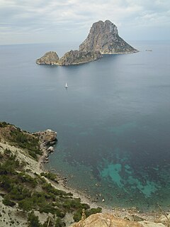
Cap Blanca is a beach on the western seaboard of the Spanish island of Ibiza. The Beach has a good view of the rock island of Es Vedrà which lies a little of the coast here. The beach is in the municipality of Sant Josep de sa Talaia and is 13.3 miles (21.4 km) west of the town of Ibiza town. The village of Sant Josep de sa Talaia is 7.0 miles (11.3 km) east of the beach.
Port d’es Torrent is in a small cove within the bay of Sant Antoni Bay. The beach is on the northern seaboard of the Spanish island of Ibiza. Although it is but a short distance from Sant Antoni, it is in the municipality of Sant Josep de sa Talaia. Platja d’es Torrent is 12.6 miles (20.3 km) north west of Ibiza town, and 3.6 miles (5.8 km) west around the bay from Sant Antoni. In 2012 Port d’es Torrent is one of the 12 blue flag beaches on the island.
Cala Benirrás is a beach in the northern seaboard of the Spanish island of Ibiza. It is in the municipality of Sant Joan de Labritja and is 4.6 miles (7.4 km) east of the village of Sant Joan de Labritja and 4.6 miles (7.4 km) north north east of the village of Sant Miquel de Balansat.