
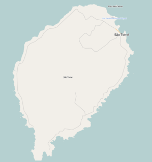
Mé-Zóchi is a district of São Tomé and Príncipe, on São Tomé Island. Its area is 122 km2 (47 sq mi). With 44,752 residents (2012), it is the second most populous district of the country. The district seat is Trindade. It is divided into the five statistical subdistricts Trindade, Madalena, Caixão Grande, Bombom and Almas.
Porto Alegre is a village in Caué District on São Tomé Island in São Tomé and Príncipe. Its population is 795. Porto Alegre lies 2.5 km northeast of the southernmost point of São Tomé Island, Ponta Homem da Capa. It is 1.5 km west of Ponta Baleia, 17 km southwest of São João dos Angolares and 40 km southwest of the capital São Tomé. Across the Canal das Rolas lies the Ilhéu das Rolas. On the east side of Ponta Homem da Capa is the beach Praia Inhame. The plantation complex Roça de Porto Alegre was established around 1890 by Jacinto Carneiro de Sousa e Almeida. The oldest preserved building dates from 1918.
Santa Catarina is a village on the western coast of São Tomé Island in São Tomé and Príncipe. Its population is 1,862. It lies 13 km southwest of Neves.
Santa Clotilde is a village in the eastern part of São Tomé Island in São Tomé and Príncipe. Its population is 112. It lies 6 km west of Santana.
São José is a village in the western part of São Tomé Island in São Tomé and Príncipe. Its population is 98. It lies 2.5 km south of Diogo Vaz, 4 km northeast of Santa Catarina and 9 km southwest of Neves.
Guegue is a village on São Tomé Island in the nation of São Tomé and Príncipe. Its population is 104. It lies in the interior of the island, 1 km north of Uba Budo and 4 km southeast of Trindade.
Lemos is a village on São Tomé Island in the nation of São Tomé and Príncipe. Its population is 1,136. It is 2 km east of Trindade.
Plateau is a village on São Tomé Island in the nation of São Tomé and Príncipe. Its population is 99. It lies 1 km northeast of Java and 4 km southwest of Trindade.
Caixão Grande is a town on São Tomé Island in the nation of São Tomé and Príncipe. Its population is 1,021. It lies about 5 km southwest of the national capital São Tomé.
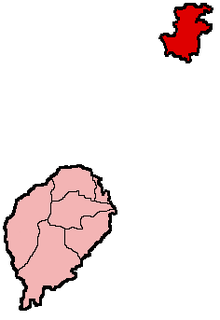
The Autonomous Region of Príncipe is an administrative division of the Republic of São Tomé and Príncipe. Established on 29 April 1995, it covers the island of Príncipe and a number of small uninhabited islands around it, with an area of 142 km2 (55 sq mi) in total. As defined by the constitution of São Tomé and Príncipe, the Autonomous Region of Príncipe has a Regional Assembly and a Regional Government. Its population was 7,324 at the 2012 census. It consists of a single district: Pagué. Its seat is the town Santo António.
Madalena is a small town on São Tomé Island in São Tomé and Príncipe. Its population is 221. It lies 1 km northeast of Santa Margarida, 2.5 km south of Boa Entrada and 7 km west of the capital São Tomé.

Praia Melão is a seaside village in the north-eastern part of São Tomé Island in São Tomé and Príncipe, part of Mé-Zóchi District. Its population is 2,668. It lies 1 km northeast of Almas, 1 km southeast of Pantufo and 4.5 km southeast of the capital São Tomé.
Almas is a town in Mé-Zóchi District, São Tomé Island, São Tomé and Príncipe. Its population is 1,255. It lies 1 km southwest of Praia Melão and 5 km south of the capital São Tomé.
São Marçal is a suburb of the city São Tomé in the nation of São Tomé and Príncipe. Its population is 2,866. It is 2.3 km southeast of the city centre of São Tomé and 1 km northwest of Pantufo.
São João da Vargem is a suburb of the city São Tomé in the nation of São Tomé and Príncipe. Its population is 1,793. It lies on the coast, 1 km northwest of the city centre of São Tomé.
Diogo Vaz is a settlement in the Lembá District on the western coast of São Tomé Island in São Tomé and Príncipe. Its population is 632. It lies 7 km southwest of Neves and 6 km northeast of Santa Catarina. It was established as a plantation complex, Roça de Diogo Vaz.
Lembá is a seaside settlement in the Lembá District in the western part of São Tomé Island in São Tomé and Príncipe. Its population is 395. It lies 2.5 km south of Santa Catarina.
Ototó is a village in the central part of São Tomé Island in São Tomé and Príncipe. Its population is 585. It lies 1 km southeast of Santa Margarida and 1.2 km south of Madalena.


