Santa Fe de la Vera Cruz is the capital city of the province of Santa Fe, Argentina. It is situated in north-eastern Argentina, near the junction of the Paraná and Salado rivers. It lies 15 kilometres (9.3 mi) from the Hernandarias Subfluvial Tunnel that connects it to the city of Paraná. The city is also connected by canal with the port of Colastiné on the Paraná River. Santa Fe de la Vera Cruz has about 391,164 inhabitants as per the 2010 census [INDEC]. The metropolitan area has a population of 653,073, making it the eighth largest in Argentina. The third largest city in Argentina is Rosario, also located in Santa Fe Province. Rosario has a population of 1.24 million and it is the largest city in Argentina not to be a provincial capital.

The Santa Ana River is the largest river entirely within Southern California in the United States. It rises in the San Bernardino Mountains and flows for most of its length through San Bernardino and Riverside Counties, before cutting through the northern Santa Ana Mountains via Santa Ana Canyon and flowing southwest through urban Orange County to drain into the Pacific Ocean. The Santa Ana River is 96 miles (154 km) long, and its drainage basin is 2,650 square miles (6,900 km2) in size.
The Santa Margarita River which with the addition of what is now Temecula Creek, was formerly known as the Temecula River, is a short intermittent river on the Pacific coast of southern California in the United States, approximately 30.9 miles (49.7 km) long. One of the last free-flowing rivers in southern California, it drains an arid region at the southern end of the Santa Ana Mountains, in the Peninsular Ranges between Los Angeles and San Diego.

The Santa Fe Trail was a 19th-century transportation route through central North America that connected Franklin, Missouri with Santa Fe, New Mexico. Pioneered in 1821 by William Becknell, who departed from the Boonslick region along the Missouri River, the trail served as a vital commercial highway until the introduction of the railroad to Santa Fe in 1880. Santa Fe was near the end of the El Camino Real de Tierra Adentro, which carried trade from Mexico City.

The Sangre de Cristo Mountains are the southernmost subrange of the Rocky Mountains. They are located in southern Colorado and northern New Mexico in the United States. The mountains run from Poncha Pass in South-Central Colorado, trending southeast and south, ending at Glorieta Pass, southeast of Santa Fe, New Mexico. The mountains contain a number of fourteen thousand foot peaks in the Colorado portion, as well as all the peaks in New Mexico which are over thirteen thousand feet.

Santa Fe de Antioquia is a municipality in the Antioquia Department, Colombia. The city is located approximately 58 kilometres (36 mi) north of Medellín, the department capital. It has a population of approximately 23,000 inhabitants.
The Galisteo Basin is a surface basin and a closely related groundwater basin in north-central New Mexico. Its primary watercourse is the Galisteo River or Galisteo Creek, a perennial stream, for part of its course, that flows from the eastern highlands down into the Rio Grande about three miles above the Santo Domingo Pueblo. The Galisteo basin covers approximately 467,200 acres and runs from San Miguel County in the east, across Santa Fe County, and into Sandoval County at its westernmost point, the Rio Grande. Northeast of Galisteo Basin rise the Sangre de Cristo Mountains and to the southwest lie the Sandia Mountains. Because of its location lying between mountain ranges and connecting the Rio Grande Valley with the Great Plains, the Galisteo Basin was used as a trade route by prehistoric and historic indigenous and later also by the Spanish explorers.

The Federal Pact was a treaty first signed by the Argentine provinces of Buenos Aires, Entre Ríos and Santa Fe on 4 January 1831, for which a Federal military alliance was created to confront the Unitarian League. Other provinces would later join the treaty.

Malibu Creek is a year-round stream in western Los Angeles County, California. It drains the southern Conejo Valley and Simi Hills, flowing south through the Santa Monica Mountains, and enters Santa Monica Bay in Malibu, California. The Malibu Creek watershed drains 109 square miles (280 km2) and its tributary creeks reach as high as 3,000 feet (910 m) into Ventura County, California. The creek's mainstem begins south of Westlake Village at the confluence of Triunfo Creek and Lobo Canyon Creek, and flows 13.4 miles (21.6 km) to Malibu Lagoon.
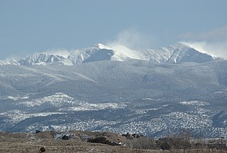
Truchas Peak is the second highest peak in the U.S. State of New Mexico behind Wheeler Peak. It is in the Sangre de Cristo Mountains 26 miles (42 km) northeast of Santa Fe. It lies within the Pecos Wilderness, part of the Santa Fe National Forest. The name of the peak is Spanish for "trout" (plural). It is the highest point in both Rio Arriba and Mora counties.

The Santa Fe National Forest is a protected national forest in northern New Mexico in the Southwestern United States. It was established in 1915 and covers 1,558,452 acres (6,306.83 km2). Elevations range from 5,300 feet (1600 m) to 13,103 feet (4000 m) at the summit of Truchas Peak, located within the Pecos Wilderness. The Jemez, Coyote, and Cuba districts are located in the Jemez Mountains; the Pecos/Las Vegas district is located in the Sangre de Cristo Mountains; and the Española district is located in both mountain ranges. In descending order of land area the forest lies in parts of Rio Arriba, San Miguel, Sandoval, Santa Fe, Mora, and Los Alamos counties. Forest headquarters are located in the city of Santa Fe.

The Santa Fe River is a 75-mile (121 km) river in northern Florida. The watershed of the river is approximately 1,380 square miles (3,574 km2) and spreads across southern Columbia, southern Suwannee, western Bradford, far southern Baker, Union, northern and eastern Gilchrist, and northern Alachua counties. The headwaters of the river are Lake Santa Fe, near Keystone Heights. The Santa Fe River is usually a slow-flowing river. This slow speed, combined with the abundant leaf-drop from nearby trees, especially Bald Cypress, leads to a very dark-brown river.
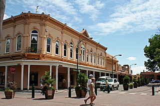
The Santa Fe New Mexican or simply The New Mexican is a daily newspaper published in Santa Fe, New Mexico. Dubbed "the West's oldest newspaper," its first issue was printed on November 28, 1849.
The San Gabriel Mountains Regional Conservancy (SGMRC) is a regional environmental organization located in the foothill area of the eastern San Gabriel Valley. It is concerned with the conservation of land, land use planning, publication of studies, watershed management, land management, and education.
The Herring Run is an 11.1-mile-long (17.9 km) tributary of the Back River located in Baltimore, Maryland.

The San Dieguito River is a major river in Southern California, United States. Its headwaters rise on the southern slope of the Volcan Mountains in San Diego County and the river flows generally southwest for 23.8 miles (38.3 km), draining 346 square miles (900 km2) before emptying into the Pacific Ocean 20 miles (32 km) north of San Diego.

The Boonslick, or Boone's Lick Country, is a cultural region of Missouri along the Missouri River that played an important role in the westward expansion of the United States and the development of Missouri's statehood in the early 19th century. The Boone's Lick Road, a route paralleling the north bank of the river between St. Charles and Franklin, Missouri, was the primary thoroughfare for settlers moving westward from St. Louis in the early 19th century. Its terminus in Franklin marked the beginning of the Santa Fe Trail, which eventually became a major conduit for Spanish trade in the American Southwest. Later it connected to the large emigrant trails, including the Oregon and California Trails, used by pioneers, gold-seekers and other early settlers of the West. The region takes its name from a salt spring or "lick" in western Howard County, where Nathan and Daniel Morgan Boone, sons of famed frontiersman Daniel Boone, built a homestead in 1807.