Albuquerque, also known locally as Duke City and abbreviated as ABQ, is the most populous city in the U.S. state of New Mexico and the 32nd-most populous city in the United States, with a census-estimated population of 558,545 in 2017. Albuquerque is the principal city of the Albuquerque metropolitan area, which has 910,726 residents as of July 2017. Albuquerque's MSA is the 60th-largest metropolitan area in the United States. The Albuquerque MSA population includes the cities of Rio Rancho, Bernalillo, Placitas, Corrales, Los Lunas, Belen, Bosque Farms, and forms part of the larger Albuquerque–Santa Fe–Las Vegas combined statistical area, with a total population of 1,171,991 in 2016.

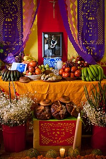
The Day of the Dead is a Mexican holiday celebrated throughout Mexico, in particular the Central and South regions, and by people of Mexican heritage elsewhere. The multi-day holiday focuses on gatherings of family and friends to pray for and remember friends and family members who have died, and help support their spiritual journey. In 2008, the tradition was inscribed in the Representative List of the Intangible Cultural Heritage of Humanity by UNESCO.

Taos is a town in Taos County in the north-central region of New Mexico in the Sangre de Cristo Mountains, incorporated in 1934. As of the 2010 census, its population was 5,716. Other nearby communities include Ranchos de Taos, Cañon, Taos Canyon, Ranchitos, El Prado, and Arroyo Seco. The town is close to Taos Pueblo, the Native American village and tribe from which it takes its name.

Michoacán, formally Michoacán de Ocampo, officially the Free and Sovereign State of Michoacán de Ocampo, is one of the 31 states which, with the Federal District, comprise the 32 Federal Entities of Mexico. The State is divided into 113 municipalities and its capital city is Morelia. The city was named after José María Morelos, one of the main heroes of the Mexican War of Independence.

The Santa Fe Trail was a 19th-century transportation route through central North America that connected Independence, Missouri with Santa Fe, New Mexico. Pioneered in 1821 by William Becknell, it served as a vital commercial highway until the introduction of the railroad to Santa Fe in 1880. Santa Fe was near the end of the El Camino Real de Tierra Adentro, which carried trade from Mexico City.

San Miguel de Allende is the name of a municipality and its principal city, both located in the far eastern part of Guanajuato, Mexico. A part of the Bajío region, the city lies 274 km (170 mi) from Mexico City, 86 km from Querétaro, and 97 km (60 mi) from the state capital of Guanajuato. The city's name derives from two persons: 16th-century friar Juan de San Miguel, and a martyr of Mexican Independence, Ignacio Allende, who was born in a house facing the city's central plaza. San Miguel de Allende was also a critical epicenter during the historic Chichimeca War (1540–1590) where the Chichimeca Confederation defeated the Spanish Empire in the initial colonization war. Today, an old section of the town is part of a proclaimed World Heritage Site, attracting thousands of tourists and new residents from abroad every year.

Greater Mexico City refers to the conurbation around Mexico City, officially called Valley of Mexico Metropolitan Area, constituted by Mexico City itself composed of 16 Municipalities—and 41 adjacent municipalities of the states of Mexico and Hidalgo. For normative purposes, however, Greater Mexico City most commonly refers to the Metropolitan Area of the Valley of Mexico an agglomeration that incorporates 18 additional municipalities. As of 2016 an estimated 21,157,000 people lived in Greater Mexico City, making it the largest metropolitan area in North America. It is surrounded by thin strips of highlands which separate it from other adjacent metropolitan areas, of which the biggest are Puebla, Toluca, and Cuernavaca-Cuautla, and together with which it makes up the Mexico City megalopolis.

Tequixquiac is a municipality located in the Zumpango Region of the State of Mexico in Mexico. The municipality is located 84 kilometres (52 mi) north of Mexico City within the valley that connects the Valley of Mexico with the Mezquital Valley. The name comes from Nahuatl and means "place of tequesquite waters". The municipal seat is the town of Santiago Tequixquiac, although both the town and municipality are commonly referred to as simply "Tequixquiac".

Ajacuba is a town and one of the 84 municipalities of Hidalgo, in central Mexico. The municipality covers an area of 192.7 km².

San Agustín Tlaxiaca is a town and one of the 84 municipalities of Hidalgo, in central-eastern Mexico. The municipality covers an area of 354.6 km².

Apaxco is a municipality located in the Zumpango Region in Mexico. The municipal territory is located at a southern pass leading out of the Mezquital Valley about 288 km (179 mi) northeast of the state capital of Toluca. The name Apaxco comes from Nahuatl.

Hueypoxtla or Villa de San Bartolomé Hueypoxtla is a town and municipal seat from Hueypoxtla Municipality in Mexico State, in Mexico. In 2010, this village had a total population of 3,989.

Tlapanaloya is a town in the municipality of Tequixquiac in Mexico State in Mexico. The town is bordered on the north La Heredad Ranch ranching The Homestead, south to the Tajo de Tequixquiac, east village Hueypoxtla and west by the town of Santiago Tequixquiac. The name Tlapanaloya is a nahuatl toponymy, means Place where is broken stones, te- is stone, tlapana is to brake, loyan is place.

Hueypoxtla is the municipality located in Zumpango Region, the northeastern part of the state of Mexico in Mexico. The municipality is located at a northern pass leading out of the Valley of Mexico and Mezquital Valley to—kilometers north of Mexico City and about km northeast of the state capital of Toluca. The name comes from Nahuatl and means "place of great merchants".

Zumpango is a region, located in the north of the State of Mexico in the country of the same name. It is also known as the Region XVI Zumpango and has seen major population growth. It has a surface area of 8.305 km² and occupies 12.8% of the state's territory. The seat of Zumpango Region is Zumpango de Ocampo city.

Santiago Tequixquiac or Tequixquiac, is a town and municipal seat from municipality of Tequixquiac in the State of Mexico, in Mexico. As of 2010, the village had a total population of 22,676.
Teotlalpan was the pre-Columbian name of a region in the north of Valley of Mexico comprising what is today the Mezquital Valley in the state of Hidalgo and adjacent areas in the State of Mexico. The region was one of two regions settled by Otomí people, the other being the region around Jilotepec and Tula, Hidalgo.. In the 18th century the name of the main part of the region came to be known as Mezquital.

San Bartolomé Parish is the Catholic church and parish house of the people of Hueypoxtla. Has always belonged to the Diocese of Cuautitlán in Mexico. This colonial building is a monument of great architectural importance dedicated to Saint Bartholomew.


