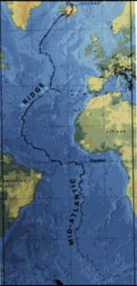
The Mid-Atlantic Ridge (MAR) is a mid-ocean ridge, a divergent tectonic plate or constructive plate boundary located along the floor of the Atlantic Ocean, and part of the longest mountain range in the world. In the North Atlantic it separates the Eurasian and North American plates, and in the South Atlantic it separates the African and South American plates. The ridge extends from a junction with the Gakkel Ridge northeast of Greenland southward to the Bouvet Triple Junction in the South Atlantic. Although the Mid-Atlantic Ridge is mostly an underwater feature, portions of it have enough elevation to extend above sea level. The section of the ridge that includes Iceland is known as the Reykjanes Ridge. The ridge has an average spreading rate of about 2.5 centimetres (0.98 in) per year.
Santa Rita is a town in Santa Rita District of the Alto Paraná Department, Paraguay.

Grenadines is an administrative parish of Saint Vincent and the Grenadines. Its capital is Port Elizabeth.
Sri Medan(铁山)is a main town in Batu Pahat District, Johor, Malaysia. Long ago, it was a famous bauxite mine in Johore.
Timaná is a town and municipality in the Huila Department, Colombia. The municipality is located in the south of Huila at an altitude of 1,100 metres (3,600 ft) and 166 kilometres (103 mi) southwest of the capital Neiva.

Contreras Island is an island in the Queen Adelaide Archipelago in Magallanes y la Antártica Chilena Region, Chile. Its area is 626 km².
Castil de Vela is a municipality located in the province of Palencia, Castile and León, Spain. According to the 2004 census (INE), the municipality has a population of 91 inhabitants.

Binkolo is a rural town in Bombali District in the Northern Province of Sierra Leone. Binkolo is home to an estimated 13,867 residents. The majority of the population are from the Limba ethnic group. The town is the birthplace of Sierra Loene's second President, Joseph Saidu Momoh.

Irishtown-Summerside is a town in the Canadian province of Newfoundland and Labrador. It is located about 2 miles north of Corner Brook. The Post Office was established on March 1, 1965 and the first Postmistress was Blanch Anderson. The town had a population of 1,418 in the Canada 2016 Census.
Hag Pike is a conspicuous rock column, 710 metres (2,330 ft) high, on the north side of the Wordie Ice Shelf near the west coast of the Antarctic Peninsula. Together with the mountain to the north, it forms the west side of the mouth of Hariot Glacier. Hag Pike was photographed from the air by the British Graham Land Expedition, 1937, and by the Ronne Antarctic Research Expedition, 1947. It was surveyed by the Falkland Islands Dependencies Survey, 1948–50, and 1958. The name by the UK Antarctic Place-Names Committee is descriptive, "hag" being the stump of a tree which remains after felling.

Ambila is a town and commune in Madagascar. It belongs to the district of Manakara, which is a part of Vatovavy-Fitovinany Region. The population of the commune was estimated to be approximately 17,000 in 2001 commune census.
Mollabayramlı is a village in the Kalbajar Rayon of Azerbaijan.

Nový Jáchymov is a municipality and village in Beroun District in the Central Bohemian Region of the Czech Republic.
Köröm is a village in Borsod-Abaúj-Zemplén County in northeastern Hungary.
Jaciara is a municipality in the state of Mato Grosso in the Central-West Region of Brazil.
Mount Metcalfe is a mountain at the south side of the head of McMorrin Glacier, 1.5 nautical miles (3 km) south of Mount Wilcox, in Graham Land, Antarctica. It was named by the UK Antarctic Place-Names Committee for Robert J. Metcalfe, a British Antarctic Survey surveyor at Stonington Island, 1960–62, who surveyed the area in 1962.
Mount Macnowski is a mountain in the northern part of the Scaife Mountains, about 5 nautical miles (9 km) west-southwest of Schmitt Mesa, near the base of the Antarctic Peninsula. It was first observed from the air by the Ronne Antarctic Research Expedition, 1947–48, and was mapped by the United States Geological Survey from surveys and U.S. Navy air photos, 1961–67. The mountain was named by the Advisory Committee on Antarctic Names for Francis B. Macnowski, a construction mechanic at South Pole Station in 1967.
Chakrane is a small town and rural commune in Al Hoceïma Province of the Taza-Al Hoceima-Taounate region of Morocco. At the time of the 2004 census, the commune had a total population of 6769 people living in 1004 households.

German submarine U-983 was a Type VIIC U-boat of Nazi Germany's Kriegsmarine during World War II.


