
Santa Rosa is a city and the county seat of Sonoma County, in the North Bay region of the Bay Area in California. Its population as of the 2020 census was 178,127. It is the largest city in California's Wine Country and Redwood Coast. It is the fifth most populous city in the Bay Area after San Jose, San Francisco, Oakland, and Fremont; and the 25th most populous city in California.

Laguna, officially the Province of Laguna, is a province in the Philippines located in the Calabarzon region in Luzon. Its capital is Santa Cruz while its largest city is the City of Calamba and the province is situated southeast of Metro Manila, south of the province of Rizal, west of Quezon, north of Batangas and east of Cavite. Laguna hugs the southern shores of Laguna de Bay, the largest lake in the country. As of the 2020 census, the province's total population is 3,382,193. It is the seventh richest province in the country.

São Tomé Island, at 854 km2 (330 sq mi), is the largest island of São Tomé and Príncipe and is home in May 2018 to about 193,380 or 96% of the nation's population. The island is divided into six districts. It is located 2 km north of the equator.

Ocotepeque is a municipality in the Honduran department of Ocotepeque. The town of Nueva Ocotepeque is the municipal seat and the capital of the department.
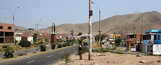
Santa Rosa is a district of the Lima Province in Peru. Officially established as a district on February 6, 1962. The district's postal code is 38. It limits to the north and the east with the Ancón District, to the west with the Pacific Ocean, to the south with the Ventanilla District.
Las Rosas is a city in the southwest of the province of Santa Fe, Argentina, located 165 km (103 mi) from the provincial capital. It has about 13,689 inhabitants as per the 2010 census [INDEC], and it is the head town of the Belgrano Department, which also comprises the municipalities of Armstrong, Bouquet, Las Parejas, Montes de Oca, and Tortugas.
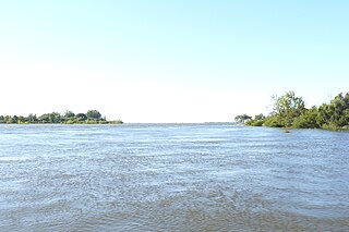
The San Javier River is an anabranch of the Paraná River in the province of Santa Fe, Argentina.

Concepción Department is a department of Corrientes Province in Argentina.
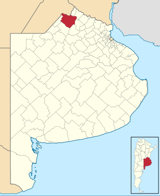
Pergamino Partido is a partido in the north of Buenos Aires Province in Argentina.

Santa Rosa is a department of Catamarca Province in Argentina.

Moita Bonita is a municipality located in the Brazilian state of Sergipe. Its population was 11,348 (2020) and covers 96.53 km2 (37.27 sq mi). Moita Bonita has a population density of 120 inhabitants per square kilometer. Moita Bonita is located 64 km (40 mi) from the state capital of Sergipe, Aracaju. Riachuelo borders the municipalities of Itabaiana, Ribeirópolis, Nossa Senhora das Dores, Santa Rosa de Lima, and Malhador, all within the state of Sergipe.
Riachuelo is a municipality located in the Brazilian state of Sergipe. Its population was 10,284 (2020) and covers 78.31 km2 (30.24 sq mi). Riachuelo has a population density of 130 inhabitants per square kilometer. Riachuelo is located 23 km (14 mi) from the state capital of Sergipe, Aracaju. Riachuelo borders the municipalities of Laranjeiras, Divina Pastora, Santa Rosa de Lima, and Areia Branca, all within the state of Sergipe. The municipality is site of the Nossa Senhora da Penha Sugar Plantation and the Chapel of the Nossa Senhora da Penha Sugar Plantation. The chapel was listed as a historic structure by National Institute of Historic and Artistic Heritage (IPHAN) in 1943, but has fallen into an advanced state of neglect and decay and is considered abandoned.

Santa Vitória do Palmar is a Brazilian city and municipality. It is the southernmost municipality in Brazil, located in the state of Rio Grande do Sul. To the west of the municipality is the Lagoa Mirim and beyond that is Uruguay; to the east and southeast lies the Atlantic Ocean, and to the north is the city of Rio Grande. To the south, it borders the municipality of Chuí and Uruguay.
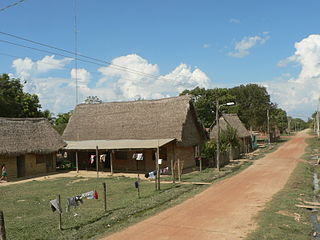
Santa Rosa de Yacuma or Santa Rosa del Yacuma is a small town in the Amazon pampas of the Bolivian Beni Department.

Tucunduva is a municipality in the state of Rio Grande do Sul, Brazil. Known as the Capital of Mechanized Crops, Tucunduva has the highest grain yield per hectare in Brazil and is also known as the Land of Musicians.

Santa Rosa de Ocopa is the name of a district of Concepción province, Department of Junin in Peru. It is also the name of the capital of the district, and the name of a historic monastery in the district called the Convent of Santa Rosa de Ocopa. In 2017, the district had a population of 2,129 and an area of 16.1 square kilometres (6.2 sq mi). The capital of the district, the town of Santa Rosa, had a population of 1,263 in 2017 and an elevation of 3,376 metres (11,076 ft) above sea level. The name "Ocopa" comes from the Quechua "ocupi," meaning "within" or "corner."
Santa María de Fe is a town and district located in the Misiones Department in Paraguay, located about 15 km from the city of San Ignacio.

Santa Rosa Beach is an unincorporated community in Walton County, Florida, United States. It is part of the Fort Walton Beach-Crestview-Destin, Florida Metropolitan Statistical Area.

Camerino Z. Mendoza Municipality is a municipality in Veracruz, Mexico. It is located about 85 km from state capital Xalapa. It has a surface of 37.84 km2. It is located at 18°48′N97°11′W.In 1898 there is established the head-board of Necoxtla's Municipality, in Santa Rosa; for decree of 1910 in village of Santa Rosa, it rises up to the category of Villa. Santa Rosa Necoxtla, in 1930, is named Camerino Z. Mendoza. By decree of November 5, 1932, the Municipality of Santa Rosa Necoxtla, it is named Camerino Z. Mendoza; the decree of July 4, 1933 raises to the political category of city, the Villa of Camerino Z. Mendoza.
Santa Rosa is a small city in the Canelones Department of southern Uruguay.
