
Stann Creek District is a district in the south east region of Belize. According to the 2010 census, the district had a population of 32,166 people. Its capital is the town of Dangriga, formerly known as "Stann Creek Town." Stann comes from "stanns," or safe havens used by colonialists coming from the "old world" to the "new world."

Corozal District is the northernmost district of the nation of Belize. The population was 33,894 in 2000. The district capital is Corozal Town.

Orange Walk District is a district in the northwest of the nation of Belize, with its district capital in Orange Walk Town.

Hattieville is a village in the Belize District of the nation of Belize. It is located at 17N 88W, at an elevation of 196 feet above mean sea level, and has a population of about 1,300 people. Hattieville was established as a refugee camp after Hurricane Hattie made many people homeless in Belize City when it hit in 1961, but it became a permanent town.
Roaring Creek is a small village in the Cayo District of Belize, just north-west of Belmopan. Its name is derived from the creek waterfalls which flow into the Belize River next to the Guanacaste Park area.
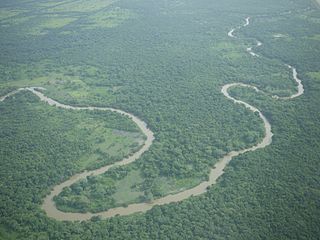
The Belize River runs 290 kilometres (180 mi) through the center of Belize. It drains more than one-quarter of the country as it winds along the northern edge of the Maya Mountains to the sea just north of Belize City. The Belize river valley is largely tropical rainforest.

Indian Church is a small remote village in the Orange Walk District of Belize. It is located on the west bank of New River, neighbouring the town of San Carlos to its south, and the Maya ruins of Lamanai to its north. According to the 2010 census, Indian Church has a population of 267 people in 66 households. The village is named for the historic Spanish churches recovered among the ancient Maya ruins. The residents lived among the ruins until 1991 when the Government of Belize established the 2-square-mile (5.2 km2) Lamanai Archaeological Reserve maintained by Belize's Institute of Archaeology.
Gardenia is a village in Belize District, Belize located about 20 miles (32 km) north of Belize City.
The San Estevan archaeological site is located in northern Belize 1 km from the modern community of San Estevan, Belize. The site is a Maya civilization site occupied during the Formative and Classic eras of Mesoamerican chronology. San Estevan is located on the New River halfway between the sites of Cerros and Lamanai. Beginning in the Late Formative period, San Estevan was a regional political center.

Cuello is a Maya archaeological site in northern Belize. The site is that of a farming village with a long occupational history. It was originally dated to 2000 BC, but these dates have now been corrected and updated to around 1200 BC. Its inhabitants lived in pole-and-thatch houses that were built on top of low plaster-coated platforms. The site contains residential groups clustered around central patios. It also features the remains of a steam bath dating to approximately 900 BC, making it the oldest steam bath found to date in the Maya lowlands. Human burials have been associated with the residential structures; the oldest have no surviving burial relics, but from 900 BC onwards, they were accompanied by offerings of ceramic vessels.
Maskall is a settlement located in the nation of Belize. It is a mainland village located in Belize District. It is 39 miles north of Belize City.
Lucky Strike is a settlement located in the nation of Belize. It is a mainland village located at mile 30½ in Belize District on the Old Northern Highway, just three miles from the Maya Site of Altun Ha.
Rockstone Pond is a settlement located in Belize. It is a mainland village located in Belize District, near the Mayan site of Altun Ha.
Crooked Tree is a settlement located in the nation of Belize. It is a mainland village located in the Belize District.
Sandhill, Belize is a populated settlement located in the nation of Belize. It is a mainland village located in the Belize District.

Scotland Halfmoon is a populated settlement located in the nation of Belize. It is a mainland village that is located in Belize District, between Burrell Boom and Bermudian Landing.
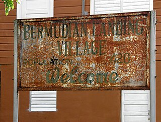
Bermudian Landing is a village in the nation of Belize, located near Scotland Halfmoon in Belize District. The name comes from the Bermuda grass planted by the early loggers to feed their oxen, who were used to drag the mahogany to the landing.
Double Head Cabbage is a village in Belize located in Belize District.

Community Baboon Sanctuary is a protected area in Belize. It was established in 1985 to help address the threats of agriculture, logging and hunting of the black howler monkey ('baboon') and to educate locals and visitors about the importance of biodiversity, sustainability, and to promote the economic development of the Bermudian Landing community.
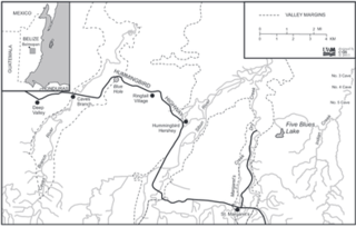
Five Blues Lake National Park is a 10-acre parcel of tropical forest in Belize, which is enclosed by over 4,000 acres of limestone hills. The lake obtained its name from the different shades of blue it reflects from the different water depths and the reflection of sunlight through the trees that frame the lake. The lake is maintained by an Association of Friends living in the Village of St. Margret's, a few minutes from the lakeside. Beside the lake is a shoreline of sunken limestone at the edge of the lake which leads to Orchid Island, where an abundance of wild orchids grows. In 2007, a drought was thought to have condemned the lake; studies were conducted to determine the cause.
This page is based on this
Wikipedia article Text is available under the
CC BY-SA 4.0 license; additional terms may apply.
Images, videos and audio are available under their respective licenses.