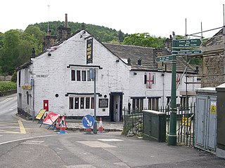
The Old White Horse Inn in Bingley, West Yorkshire, England, is one of the oldest buildings still in use in the town. It was originally constructed as a coaching inn in the mid-seventeenth century, strategically positioned with Ireland Bridge on the one side and the Parish church on the other. The building is an English Grade II listed building and has a significant amount of coaching inn infrastructure surviving including a stable, barn and two coach entrances which are located around an inner courtyard. On each side of the gable are stone lanterns that denote the former owners Order of Knights of St John of Jerusalem. There is evidence that a hostelry has been on the site since 1379.
Wasagamack First Nation is an Oji-Cree First Nation band government in Manitoba, Canada. As of December 2014 the registered population of the Wasagamack First Nation was 2,017, of which 1,823 lived on their own reserve.

Homathko Estuary Provincial Park is a provincial park in British Columbia, Canada, located at the head of Bute Inlet surrounding the mouth of the Homathko River in the Pacific Ranges of the Coast Mountains.
Querocoto District is one of nineteen districts of the province Chota in Peru.
Quarry Wood nature reserve is a 7-acre (28,000 m2) woodland on the west side of the A41 road at Hinstock in Shropshire that is managed by the Shropshire Wildlife Trust. Oak, birch and occasional hornbeam grow alongside swathes of rhododendron. The sandstone cliffs were formed in the Triassic period, around 220 million years ago, when this part of the country was hot and dry and dinosaurs were first emerging.
Green Township is a civil township in Barnes County, North Dakota, United States. As of the 2000 census, its population was 97.
Terreton is an unincorporated agricultural community in Jefferson County, Idaho, United States. It is located at an altitude of 4,790 feet, east of Mud Lake.
Marshfield is a hamlet in the town of North Collins in southern Erie County, New York, United States.

Crypt Falls is a waterfall in southwestern Alberta in Waterton Lakes National Park. It is viewable from the Crypt Lake Trail via ferry service from the Waterton town-site. It drops out of Crypt Lake and feeds a smaller lake below it. The true height of the fall is unknown but it is estimated to be taller than it currently is listed as.
Väike-Võhma is a village in Saaremaa Parish, Saare County in western Estonia.
Little Cedar River is an 8.1-mile-long (13.0 km) river in Gladwin County in the U.S. state of Michigan.

Vartanants Square or Vardanants Square, is the large central town square in Gyumri, Armenia. It is bordered by the Abovyan street from the west, Gai street from the north, Shahumyan street from the east and Vahan Cheraz street from the south. It has a rectangular shape.
Stone Barn Castle is located in Vienna, New York. Designed by Charles William Knight, the castle was completed in 1906. The castle operated as a functional dairy farm, until it went bankrupt during the Great Depression. A fire destroyed much of the castle in 1946.
Johnsons Corners is an unincorporated community in Wayne County, in the U.S. state of Ohio.
Fishburg is an extinct town in Montgomery County, in the U.S. state of Ohio. The exact location of the town is unknown to the GNIS.
Turtle Butte is a summit in Tripp County, South Dakota, in the United States. With an elevation of 2,343 feet (714 m), Turtle Butte is the 456th highest summit in the state of South Dakota.
Little Hatchet Mountains is a mountain range in Hidalgo and Grant Counties, New Mexico. The range trends north and south between Hatchita Valley to the east and Playas Valley to the west. Its tallest height is Hatchita Peak located at 31°50′30″N108°27′09″W at an elevation of 6,611 feet / 2,015 meters in Hidalgo County.
Eaudevie is an extinct town in southern Christian County, in the U.S. state of Missouri. The community was located along the east bank of Bull Creek at 36°50′30″N93°10′59″W at an elevation of 900 feet. U.S. 65 passes two miles west of the location.
Oak Ridge is an unincorporated community in Pemiscot County, in the U.S. state of Missouri.

Panhandle is an unincorporated community in Wayne Township, Jefferson County, Ohio, United States. It is located northwest of Bloomingdale and just west of Unionport at the intersection of Carman Road and Township Road 201, at 40°21′31″N80°52′07″W.

