
Lisbon District is a district located in the South Central Portugal, the district capital is the city of Lisbon, also the national capital. From its creation until 1926, it included the area of the current Setúbal District.

Santa Cruz is a town in Saint Elizabeth, Jamaica, on the A2 road connecting Black River to Mandeville. A minor market village until the 1950s, the development of nearby areas for bauxite mining stimulated its growth in the 1950s and 1960s, as did the establishment of the St. Elizabeth Technical High School in 1961. Santa Cruz has its own courthouse, police station and a wide variety of restaurants alongside supermarkets.
Malvern is a village in the Santa Cruz Mountains in Jamaica's St. Elizabeth parish.

Ömböly is a village in Szabolcs-Szatmár-Bereg county, in the Northern Great Plain region of eastern Hungary.

Moyvoughly is a hamlet in the rolling countryside north of Moate in County Westmeath. It is about 5 km from the town.
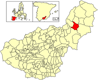
Benamaurel is a village located in the province of Granada, Spain. According to the 2006 census (INE), the city has a population of 2328 inhabitants. The municipality includes the following localities: Puente Arriba, San Marcos, Cuevas de la Blanca, Huerta Real, Cuevas del Negro y Cuevas de Luna. There is a market held every Sunday morning and a 3-day Moors and Christians festival held in April.

Benuza is a village and municipality located in the region of El Bierzo. According to the 2010 census (INE), the municipality has a population of 601 inhabitants.
Toreno is a village and municipality located in the region of El Bierzo. According to the 2004 census (INE), the municipality has a population of 3,792 inhabitants.
Pedralba de la Pradería is a municipality located in the province of Zamora, Castile and León, Spain. According to the 2004 census (INE), the municipality has a population of 280 inhabitants.

Glascoed is a village in Monmouthshire, south east Wales, United Kingdom.

Founa is a town in the Sanaba Department of Banwa Province in western Burkina Faso. As of 2005 it had a population of 1,677.
Ben is a village in the Tansila Department of Banwa Province in western Burkina Faso. As of 2005 it had a population of 901. It lies near the border with Mali.
Ouarégou is a town in the Garango Department of Boulgou Province in south-eastern Burkina Faso. As of 2005, the town has a population of 9,090.
Sampa is a village in the Tenkodogo Department of Boulgou Province in south-eastern Burkina Faso. As of 2005, the village has a population of 684.
Noali is a town in the Piéla Department of Gnagna Province in eastern Burkina Faso. The town has a population of 1038.
Kukuom is a town in the Brong Ahafo Region of Ghana. The Kukuom Agric Secondary Secondary is located in the town. The school is a second cycle institution.
Huércanos is a village in the province and autonomous community of La Rioja, Spain. The municipality covers an area of 21.48 square kilometres (8.29 sq mi) and as of 2011 had a population of 917 people.
El Rasillo de Cameros is a village in the province and autonomous community of La Rioja, Spain. The municipality covers an area of 15.85 square kilometres (6.12 sq mi) and as of 2011 had a population of 150 people.
Uruñuela is a village in the province and autonomous community of La Rioja, Spain. The municipality covers an area of 13.9 square kilometres (5.4 sq mi) and as of 2011 had a population of 952 people.
Gálvez is a village in the province of Toledo and autonomous community of Castile-La Mancha, Spain.


