Saquish

Last updated
Map of Saquish Neck showing Saquish Head Saquish Neck Map.JPG
Map of Saquish Neck showing Saquish Head
Plymouth Light in the earthworks of Fort Andrew Plymouth Light Single Tower MA.JPG
Plymouth Light in the earthworks of Fort Andrew

Saquish Beach, sometimes simply referred to as Saquish, is a beach and headland located at the end of the peninsula at the entrance to Plymouth Bay in Plymouth, Massachusetts. A small private settlement of summer cottages line the beach and headland, sometimes referred to as Saquish Neck and Saquish Head respectively. It is located east of Clark's Island and west of Gurnet Point. Its only access by land is from the Powder Point Bridge at Duxbury Beach, 5 miles to the north by foot or by 4-wheel drive beach buggies. As a private beach, access is restricted to property owners, residents, and their guests.

Contents

Saquish was likely an island at the time of the arrival of the Pilgrims. [1] [2] [3] The prevailing story concerning the name "Saquish" is that it derives from a Wampanoag name meaning "abundance of clams", but one writer says he believes it to mean "small creek". [4]

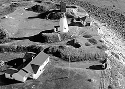
The peninsula includes Plymouth Light and the remains of the Civil War Fort Andrew and Fort Standish. Fort Andrew was preceded by Gurnet Fort in the Revolutionary War. [5] [6]

Today, many summer cottages line the beach. Because there is no electrical connection with the mainland, houses operate under solar, wind, or propane power. The nearest retail and service area is in Hall's Corner, Duxbury. Catholic mass is held weekly on the beach on Saturdays from Independence Day to Labor Day. Entrance to the Gurnet Point and Saquish is guarded by security services and it is required that visitors check in prior to entering the beach.

See also

Related Research Articles

John Alden Crew member on the Mayflower

John Alden was a crew member on the historic 1620 voyage of the Mayflower which brought the English settlers commonly known as Pilgrims to Plymouth Colony in present-day Massachusetts, US. He was hired in Southampton, England, as the ship's cooper, responsible for maintaining the ship's barrels. Although he was a member of the ship's crew and not a settler, Alden decided to remain in Plymouth Colony when the Mayflower returned to England. He was a signatory to the Mayflower Compact.

Myles Standish English military officer hired by the Pilgrims (1584–1656)

Myles Standish was an English military officer. He was hired as military adviser for Plymouth Colony in present-day Massachusetts, United States by the Pilgrims. Standish accompanied the Pilgrims on the ship Mayflower and played a leading role in the administration and defense of Plymouth Colony from its foundation in 1620. On February 17, 1621, the Plymouth Colony militia elected him as its first commander and continued to re-elect him to that position for the remainder of his life. Standish served at various times as an agent of Plymouth Colony on a return trip to England, as assistant governor of the colony, and as its treasurer.

Plymouth Colony English colonial venture in America (1620–1691)

Plymouth Colony was an English colonial venture in America from 1620 to 1691 at a location that had previously been surveyed and named by Captain John Smith. The settlement served as the capital of the colony and developed as the town of Plymouth, Massachusetts. At its height, Plymouth Colony occupied most of the southeastern portion of Massachusetts.

Hull, Massachusetts Town in Massachusetts, United States

Hull is a town in Plymouth County, Massachusetts, United States, located on a peninsula at the southern edge of Boston Harbor. Its population was 10,072 at the 2020 census. Hull is the smallest town by land area in Plymouth County and the fourth smallest in the state. However, its population density is nearly four times that of Massachusetts as a whole.

Duxbury, Massachusetts Town in Massachusetts, United States

Duxbury is a historic seaside town in Plymouth County, Massachusetts, United States. A suburb located on the South Shore approximately 35 miles (56 km) to the southeast of Boston, the population was 16,090 at the 2020 census.

Plymouth, Massachusetts Town in Massachusetts, United States

Plymouth is a town in Plymouth County, Massachusetts. The town holds a place of great prominence in American history, folklore, and culture, and is known as "America's Hometown." Plymouth was the site of the colony founded in 1620 by the Mayflower Pilgrims, where New England was first established. It is the oldest municipality in New England and one of the oldest in the United States. The town has served as the location of several prominent events, one of the more notable being the First Thanksgiving feast. Plymouth served as the capital of Plymouth Colony from its founding in 1620 until the colony's merger with the Massachusetts Bay Colony in 1691. The English explorer John Smith named the area Plymouth and the region 'New England' during his voyage of 1614. It was a later coincidence that, after an aborted attempt to make the 1620 trans-Atlantic crossing from Southampton, the Mayflower finally set sail for America from Plymouth, England.

Massasoit

Massasoit Sachem or Ousamequin was the sachem or leader of the Wampanoag confederacy. Massasoit means Great Sachem.

Priscilla Alden

Priscilla Alden was a noted member of Massachusetts's Plymouth Colony of Pilgrims and the wife of fellow colonist John Alden. They married in 1621 in Plymouth.

Duxbury Beach

Duxbury Beach is a barrier beach in the town of Duxbury, Massachusetts. It is six miles long and is accessed by the Powder Point Bridge from Duxbury, or Gurnet Road from Marshfield. Since 1975, approximately 4.5 miles of the beach is owned by Duxbury Beach Reservation, Inc, which annually leases a substantial portion of the beach--excepting the Duxbury Beach Park area--to the town of Duxbury. Under this arrangement, the town issues beach vehicle permits, provides police protection, and provides conservation officers to patrol the beach in all seasons of the year.

Plymouth Bay

Plymouth Bay is a small, well-protected bay of the Atlantic Ocean on the western shore of larger Cape Cod Bay along the coastline of the Commonwealth of Massachusetts. Plymouth Bay retains historical significance for the landing at Plymouth Rock in 1620 by the Pilgrims aboard the Mayflower who proceeded to establish the first permanent Northern European settlement in North America at Plymouth Colony.

Clarks Island

Clark's Island is the name of a small island located in Duxbury Bay in the U.S. state of Massachusetts. It was named for John Clark, the first mate of the Mayflower, the ship that brought the Pilgrims to New England. The island was initially considered for the location of the Pilgrim's settlement, but was rejected in favor of a site to the south, which became known as Plymouth, Massachusetts. Today Clark's Island is a part of the town of Plymouth.

South Plymouth is the portion of Plymouth, Massachusetts, United States that covers much of the southern section of the town beginning at the Pine Hills, a large, mostly undeveloped forested area south of Plymouth Beach, Chiltonville and South Pond. The remainder of the section is south and east of the northeastern entrance to Myles Standish State Forest, stretching to the Bourne and Wareham town lines.

Warren Cove (Massachusetts)

Warren Cove is an exclusive oceanfront residential area Plymouth Bay in Plymouth, Massachusetts. Plymouth Beach and Rocky Point surround the southern edge of the cove. Stately homes along Warren Avenue have a commanding view of Plymouth Long Beach, Gurnet Light, Duxbury Bay, "Bug Light", Saquish, and Kingston Shores.

Plymouth Light

Plymouth Light, also known as Gurnet Light, is a historic lighthouse located on Gurnet Point at the entrance to Plymouth Bay in the town of Plymouth, Massachusetts. The light is accessible only by passing through the town of Duxbury, which lies to the north. The tower is located inside the earthworks of Fort Andrew, which existed in the Civil War, War of 1812, and Revolutionary War.

Gurnet Point, Massachusetts

Gurnet Point, also known as The Gurnet, is located at the end of the peninsula at the entrance to Plymouth Bay in Plymouth, Massachusetts, and is a headland and the small private settlement located on it. The Pilgrims who settled Plymouth in 1620 named it Gurnett's Nose for its resemblance to headlands in the English Channel where gurnett fish were plentiful. The Gurnet is the home of Plymouth (Gurnet) Lighthouse as well as Fort Andrew from the Revolutionary War and Civil War. Its access by land is either from Gurnet Road in Duxbury or from the Powder Point Bridge at Duxbury Beach 5 miles to the north by foot or by 4-wheel drive beach buggies, but access is restricted to property owners, residents and their guests, except for once a year on Memorial Day when the lighthouse is open to the public.

Fort Andrew

Fort Andrew is a former fort built as Gurnet Fort in 1776 for the American Revolutionary War on Gurnet Point in Plymouth, Massachusetts. It became a federal fort and was rebuilt in 1808, and again in 1863 during the Civil War when it received its current name. It is named for John A. Andrew, governor of Massachusetts 1861–1866. In 1863 Fort Standish was built nearby on Saquish Head. After the war, the federal government declared Fort Andrew an inactive military reservation in 1869. The reservation was sold in 1926 and mostly became private property, except for the US Coast Guard light station. A World War II fire control tower was built on the parapet of the old fort. Plymouth lighthouse is also on Gurnet Point, and was moved inside the fort's earthworks to protect it from beach erosion in 1997–1998.

Duxbury Bay (Massachusetts)

Duxbury Bay is a bay on the coast of Massachusetts in the United States. The west shore of the bay is the town of Duxbury, Massachusetts; and the bay is formed by a sandbar called The Gurnet extending southeasterly from Marshfield, Massachusetts into Cape Cod Bay. The town of Marshfield was named for the estuarine wetland at the north end of the bay. The bay opens southerly toward Plymouth, Massachusetts between Captains Hill to the west and Saquish Head to the east.

Myles Standish Burial Ground Cemetery in Duxbury, Massachusetts, US

The Myles Standish Burial Ground in Duxbury, Massachusetts is, according to the American Cemetery Association, the oldest maintained cemetery in the United States.

Philip Delano arrived in Plymouth Colony in November 1621 on the voyage of the ship Fortune. He was about 18 years of age on arrival. Mayflower passenger Francis Cooke was his uncle with whom he may initially have resided. Philip Delano lived a long life in Plymouth Colony where he became a person of some note, being involved in numerous governmental activities such as civil commissions and juries. Among his early activities was in becoming a very young (investment) Purchaser in 1626 and making the first recorded land sale in Plymouth after the institution of private property. At his death it is believed he had become a person of some wealth.

Fort Standish (Plymouth, Massachusetts) Fort in Massachusetts

Fort Standish was a fort built in 1863 for the American Civil War on Saquish Head in Plymouth, Massachusetts. It was named for Myles Standish, military leader of the Plymouth Colony in the 1620s, and augmented the nearby Fort Andrew on Gurnet Point. It was designed and constructed under the supervision of Major Charles E. Blunt of the United States Army Corps of Engineers. The fort had five gun emplacements with five 8-inch smoothbore guns, along with a bombproof shelter, two magazines, and a well. Outside the fort were a barracks, officers' quarters, and a mess hall. From January to June 1865 the fort was garrisoned by the 27th Unattached Company of Massachusetts militia.

References

  1. Henderson, Helen (1919). A Loiterer in New England. New York: George H. Doran Company. p. 172.
  2. Goodwin, John Abbott (1888). The Pilgrim Republic: An Historical Review of the Colony of New Plymouth, with Sketches of the Rise of Other New England Settlements, the History of Congregationalism, and the Creeds of the Period (Google eBook). Boston and New York: Houghton Mifflin. p. 97.
  3. The Gurnet by Charles W.E. Morris at Pilgrimhall.org
  4. Kinnicutt, Lincoln Newton (1909). Indian names of places in Plymouth, Middleborough, Lakeville and Carver, Plymouth County, Massachusetts: with interpretations of some of them. Worcester, Massachusetts: Commonwealth Press. pp.  33, 34.
  5. "Massachusetts - Fort Andrew and Gurnet Fort". American Forts Network. Retrieved 16 June 2020.
  6. "Massachusetts - Fort Standish (1)". American Forts Network. Retrieved 16 June 2020.

Coordinates: 42°00′13″N70°37′28″W / 42.003578°N 70.624336°W / 42.003578; -70.624336