Related Research Articles
Chambers County is a county in the U.S. state of Texas. As of the 2010 census, the population was 35,096. The county seat is Anahuac.

Anahuac is a city in the U.S. state of Texas. The population of the city was 2,243 at the 2010 census. Anahuac is the seat of Chambers County and is situated in Southeast Texas. The Texas Legislature designated the city as the "Alligator Capital of Texas" in 1989. Anahuac hosts an annual alligator festival.

The Adams–Onís Treaty of 1819, also known as the Transcontinental Treaty, the Florida Purchase Treaty, or the Florida Treaty, was a treaty between the United States and Spain in 1819 that ceded Florida to the U.S. and defined the boundary between the U.S. and New Spain. It settled a standing border dispute between the two countries and was considered a triumph of American diplomacy. It came in the midst of increasing tensions related to Spain's territorial boundaries in North America against the United States and Great Britain in the aftermath of the American Revolution; it also came during the Latin American wars of independence.
Hidalgotitlán is a town in the Mexican state of Veracruz, with a population of near 18,000 in 2000. Its name derives from two words: one Spanish and the other indigenous. The first part is the family name Hidalgo, and the second part is -tlan, a Nahuatl suffix that means "place".

Gods River is a remote, isolated settlement in Northern Manitoba, Canada and the primary settlement of the Manto Sipi Cree Nation First Nations community. The settlement is on Gods Lake at the point of outflow of the Gods River.
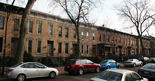
The Burling Row House District is a historic district in Chicago, Illinois, United States. The district was built in the post-Chicago Fire year of 1875 by Edward J. Burling. It was designated a Chicago Landmark on November 15, 2000.

Mingo Township is one of twenty-four townships in Bates County, Missouri, and is part of the Kansas City metropolitan area within the USA. As of the 2000 census, its population was 235.

New Home Township is one of twenty-four townships in Bates County, Missouri, and is part of the Kansas City metropolitan area within the USA. As of the 2000 census, its population was 222.
Agua Dulce Municipality is a municipality in Veracruz, Mexico. It is located about 330 kilometres (210 mi) southeast from the state capital Xalapa. It has an area of 259.25 square kilometres (100.10 sq mi).
Moloacán is a municipality in Veracruz, Mexico. It is located in south-east zone of the State of Veracruz, about 456 km from state capital Xalapa. It has a surface of 261.57 km2. It is located at 17°59′N94°21′W.
Oluta is a Municipality in Veracruz, Mexico. It is located in south-east zone of the State of Veracruz, about 371 km from state capital Xalapa. It has a surface of 90.48 km2. It is located at 17°56′N94°54′W.
Sayula is a municipality located in the plains of the Sotavento zone in the central zone of the State of Veracruz in Mexico, about 382 km from state capital Xalapa. It has a surface area of 640.76 km2 (247 sq mi). It is located at 17°53′N94°57′W.
Soconusco Municipality is a municipality in Mexico located to the south-east of the State in the Plains of the Sotavento of Veracruz, about 275 kilometres (171 mi) from state capital Xalapa. It has an area of 94.59 square kilometres (36.52 sq mi). It is located at 17°58′N94°53′W.
Texistepec is a municipality located in the south-east zone in the State of Veracruz, about 285 km from state capital Xalapa. It has a surface of 615.26 km2. It is located at 17°54′N94°49′W. Texistepec in 1580 concerned to Coatzacoalcos's province. In 1831 San Miguel Texistepec was forming a municipality and was possessing 2 square leagues of lands with legal titles, southern people who suffered the batterings of the currents that our Mexican Republic had.
The Sinaloa River is a river of Mexico. It runs across the state of Sinaloa from northeast to southwest, beginning in the Sierra Madre Occidental and emptying into the Gulf of California. Its flow is interrupted mostly by the Bacurato Dam which created Lake Baccarac in 1978. Below the dam, the flow of the river is largely diverted by an irrigation canal near the town of Sinaloa de Leyva.
The Río Verde (Chihuahua) is a river of Mexico.
Black Creek of Arizona is a 55-mi (89 km) long north tributary of the Puerco River, in northeast Arizona and northwest New Mexico.
The Sree River is a rivers in the northern part of Bangladesh,. It passes through Joypurhat Sadar and Akkelpur Upazilas of Joypurhat District.
Bowers Mill is an unincorporated community in Jasper and Lawrence counties, in the U.S. state of Missouri. The community and mill are located on the Spring River midway between Mount Vernon to the east and Carthage to the west. La Russell lies just to the south.

Moosomin 112P is an Indian reserve of the Moosomin First Nation in Saskatchewan. It is 29 kilometers north of Hafford.
References
- "Atlas of Mexico – River Basins (Map from book)". lib.utexas.edu. 1975. Archived from the original on 2011-11-07.
- The Prentice Hall American World Atlas, 1984.
- Rand McNally, The New International Atlas, 1993.
Coordinates: 17°11′36″N94°55′22″W / 17.1934°N 94.9229°W
| This article related to a river in Mexico is a stub. You can help Wikipedia by expanding it. |