Related Research Articles

Bahia is one of the 26 states of Brazil, located in the Northeast Region of the country. It is the fourth-largest Brazilian state by population and the 5th-largest by area. Bahia's capital is the city of Salvador, on a spit of land separating the Bay of All Saints from the Atlantic. Once a monarchial stronghold dominated by agricultural, slaving, and ranching interests, Bahia is now a predominantly working-class industrial and agricultural state. The state is home to 7% of the Brazilian population and produces 4.2% of the country's GDP.

The São Francisco River is a large river in Brazil. With a length of 2,914 kilometres (1,811 mi), it is the longest river that runs entirely in Brazilian territory, and the fourth longest in South America and overall in Brazil. It used to be known as the Opara by the indigenous people before colonisation, and is today also known as "Velho Chico".
Caldeirão Grande is a Brazilian municipality in the state of Bahia. Its estimated population as of 2020 was 13,391 inhabitants, up from 12,491 in 2010. It has an area of 458.31 square kilometres (176.95 sq mi). As of 2020, the mayor was Candido Pereira da Guirra Filho.

Serrinha is a city in the state of Bahia, in eastern Brazil.

Candeias is a municipality in Brazil, in the state of Bahia. It is located 46 kilometres (29 mi) to the north of Salvador, the capital of Bahia. The town is near the BR-324 motorway. The town has a current population of 87,458.
The Catolé Grande River is a river of Bahia state in eastern Brazil.
Lagoa Grande is a city in the Brazilian state of Pernambuco, 665 km away from the state's capital, Recife. The population in 2020, according with IBGE was 25,849 inhabitants and the total area is 1850.07 km².
Iaçu is a municipality in the state of Bahia in the North-East region of Brazil.
Ibiquera is a municipality in the state of Bahia in the North-East region of Brazil.
Lajedinho is a municipality in the state of Bahia in the North-East region of Brazil.
Macajuba is a municipality in the state of Bahia in the North-East region of Brazil.
Várzea da Roça is a municipality in the state of Bahia in the North-East region of Brazil.

Jaguarari is a municipality in the state of Bahia in the North-East region of Brazil.
Itapetinga, Bahia, Brazil is a municipality in the state of Bahia in the North-East region of Brazil. Its population in 2020, according to estimates by the IBGE, was 76,795, so it is the 24th most populous municipality of Bahia.
Lafaiete Coutinho is a municipality in the state of Bahia in the North-East region of Brazil.
Itaeté is a municipality in the state of Bahia in the North-East region of Brazil.
Planalto, Bahia is a municipality in the state of Bahia in the North-East region of Brazil.

Madre de Deus is a municipality in the state of Bahia in the North-East region of Brazil. The municipality is located on a small archipelago in the Bay of All Saints; it both the smallest municipality by land mass in Bahia and the Northeastern region of Brazil. Madre de Deus is spread across two islands, the Ilha de Madre de Deus and the much smaller Ilha de Maria Guarda. It sits in close proximity to two others islands, the Ilha do Bom Jesus dos Passos and Ilha dos Frades, both part of the city of Salvador. The Ilha de Madre de Deus is further subdivided into the neighborhoods of Centro, Suape, Cação, Marezinha, Mirim, Alto do Paraíso, Apicum, Nova Madre de Deus e Quitéria, Alto da Matriz, Alto do Santo Antônio, Alto da Boa Vista, Cururupeba, Malvinas, and Nova Brasília.
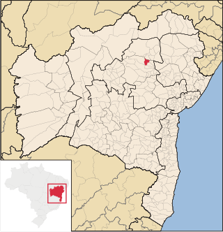
Sento Sé is a municipality in the state of Bahia in the North-East region of Brazil. It covers 12,698.76 km2 (4,903.02 sq mi), and has a population of 40,989 with a population density of 1.28 inhabitants per square kilometer. Sento Sé is located 689 kilometres (428 mi) from the state capital of Salvador.
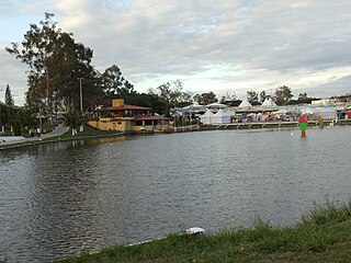
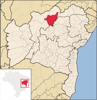
Saúde is a municipality in the state of Bahia in the North-East region of Brazil. Its population estimated in 2020 is 12,943.
References
Coordinates: 12°19′47″S40°06′43″W / 12.32973°S 40.11203°W