
Baker Island, formerly known as New Nantucket, is an uninhabited atoll just north of the Equator in the central Pacific Ocean about 3,090 km (1,920 mi) southwest of Honolulu. The island lies almost halfway between Hawaii and Australia. Its nearest neighbor is Howland Island, 42 mi (68 km) to the north-northwest; both have been claimed as territories of the United States since 1857, though the United Kingdom considered them part of the British Empire between 1897 and 1936.
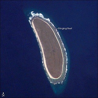
Howland Island is an uninhabited coral island located just north of the equator in the central Pacific Ocean, about 1,700 nautical miles (3,100 km) southwest of Honolulu. The island lies almost halfway between Hawaii and Australia and is an unorganized, unincorporated territory of the United States. Together with Baker Island it forms part of the Phoenix Islands. For statistical purposes, Howland is grouped as one of the United States Minor Outlying Islands. The island has an elongated cucumber-shape on a north–south axis, 1.40 by 0.55 miles, and covers 1 square mile.

Jarvis Island is an uninhabited 4.5 km2 (1.7 sq mi) coral island located in the South Pacific Ocean, about halfway between Hawaii and the Cook Islands. It is an unincorporated, unorganized territory of the United States, administered by the United States Fish and Wildlife Service of the United States Department of the Interior as part of the National Wildlife Refuge system. Unlike most coral atolls, the lagoon on Jarvis is wholly dry.

Kingman Reef is a largely submerged, uninhabited, triangle-shaped reef, geologically an atoll, 9.0 nmi (20 km) east-west and 4.5 nmi (8 km) north-south, in the North Pacific Ocean, roughly halfway between the Hawaiian Islands and American Samoa. It has an area of 3 hectares and is one of the unincorporated territories of the United States in Oceania. The reef is administered by the United States Fish and Wildlife Service as the Kingman Reef National Wildlife Refuge. It was claimed by the US in 1859, and later used briefly as stopover for commercial Pacific flying boat routes in the 1930s, until there was aircraft disaster with one of the flying boats serving the route. It was administered by the Navy from 1934 to 2000, and thereafter the Fish and Wildlife service, and in the 21st century its the area is atoll and marine nature reserve. In the 19th century it was noted as maritime hazard, and was originally called Hazard Rocks, and is known to have been hit once in 1876. In the 21st it is noted for is marine biodiversity and remote nature.

Malden Island, sometimes called Independence Island in the 19th century, is a low, arid, uninhabited atoll in the central Pacific Ocean, about 39 km2 (15 sq mi) in area. It is one of the Line Islands belonging to the Republic of Kiribati. The lagoon is entirely enclosed by land, though it is connected to the sea by underground channels, and is quite salty.
The Phoenix Islands, or Rawaki, are a group of eight atolls and two submerged coral reefs that lie east of the Gilbert Islands and west of the Line Islands in the central Pacific Ocean, north of Samoa. They are part of the Republic of Kiribati. Their combined land area is 28 square kilometres (11 sq mi). The only island of any commercial importance is Canton Island. The other islands are Enderbury, Rawaki, Manra, Birnie, McKean, Nikumaroro, and Orona.

The Guano Islands Act is a United States federal law passed by the Congress that enables citizens of the United States to take possession in the name of the United States of unclaimed islands containing guano deposits. The islands can be located anywhere, so long as they are not occupied by citizens of another country and not within the jurisdiction of another government. It also empowers the president to use the military to protect such interests and establishes the criminal jurisdiction of the United States in these territories.

Starbuck Island is an uninhabited coral island in the central Pacific, and is part of the Central Line Islands of Kiribati. Its former names include "Barren Island", "Coral Queen Island", "Hero Island", "Low Island", and "Starve Island".

Atafu, formerly known as the Duke of York Group, is a group of 52 coral islets within Tokelau in the south Pacific Ocean, 500 kilometres north of Samoa. With a land area of 2.5 square kilometres, it is the smallest of the three islands that constitute Tokelau. It is an atoll and surrounds a central lagoon, which covers some 15 km2 (5.8 sq mi). The atoll lies 800 kilometres south of the equator at 8° 35' South, 172° 30' West.

Nukunonu is the largest atoll within Tokelau, a dependency of New Zealand, in the south Pacific Ocean. It comprises 30 islets surrounding a central lagoon, with about 5.5 km2 (2.1 sq mi) of land area and a lagoon surface area of 109 km2 (42 sq mi). Motuhaga is the only islet that has inhabitants. It has an estimated population of 448.

The Canton and Enderbury Islands consist of the coral atolls of Canton Island and Enderbury in the northeastern part of the Phoenix Islands, about 1,850 miles (3,000 km) south of Hawaii in the central Pacific Ocean.

The Swan Islands is a chain of three islands located in the northwestern Caribbean Sea, approximately 153 km (95 mi) northeast of the eastern coast of Honduras, with a combined land area of 3.1 km2 (1.2 sq mi).

Birnie Island is a small, uninhabited coral island, 20 hectares in area, part of the Phoenix Island group, that is part of the Republic of Kiribati. It is located about 100 kilometres southeast of Kanton Island and 90 kilometres west-northwest of Rawaki Island, formerly known as Phoenix Island. It lies at 03°35′S171°33′W. Birnie Island measures only 1.2 kilometres (0.75 mi) long and 0.5 kilometres (0.3 mi) wide. There is no anchorage, but landing can be made on the lee shore.
The Alto Velo Claim, also referred to as the Alta Vela Affair, was a territorial claim against the Dominican government by American adventurers ejected from Alto Velo Island by Dominican officials in October 1860. In all, three companies claimed U.S. protection of their right to mine guano from the island under the Guano Islands Act of 1856, but the U.S. Department of State never recognized U.S. interests in the island.

McKean Island is a small, uninhabited island in the Phoenix Islands, Republic of Kiribati. Its area is 57 hectares.
Rawaki is one of the Phoenix Islands in the Republic of Kiribati, also known by its previous name of Phoenix Island. It is a small, uninhabited atoll, approximately 1.2 by 0.8 kilometres in size and 65 hectares in area, with a shallow, brackish lagoon that is not connected to the open sea. It is located at 3.721°S 170.712°W.
Guano is the accumulated excrement of seabirds or bats. Guano is a highly effective fertilizer due to the high content of nitrogen, phosphate, and potassium, all key nutrients essential for plant growth. Guano was also, to a lesser extent, sought for the production of gunpowder and other explosive materials.

Ganges Island, a phantom island known as Nakanotorishima in Japanese, appeared at 30°45′N154°25′E on maps of the late 19th and early 20th centuries. Reports of its disappearance appeared in 1933.

White Swallow was an extreme clipper built in Boston in 1853 for the California trade.
