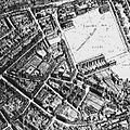
Sardinia Street, Lincoln's Inn

Last updated

View of the entrance to Lincoln's Inn Fields in Duke Street by John Crowther, referring to this entrance, a side entrance. View of the entrance to Lincoln's Inn Fields in Duke Street by John Crowther.jpeg
View of the entrance to Lincoln's Inn Fields in Duke Street by John Crowther, referring to this entrance, a side entrance.

Sardinia Street, formerly Duke Street was the northern continuation of Kemble Street (formerly Princes Street). It ended, like its successor, on the west side (carriageway) of Lincoln's Inn Fields in the north, but further north. It was joined on its western side by King's Head Yard (demolished) and Wild Street (formerly Great Wild Street), and opposite by Vere Street (demolished). On the eastern side at the northern end was a Roman Catholic chapel and chapel yard.

Contents

History

Descriptive map of London poverty, 1889 Wellcome L0074436.jpg
Street marked by north-south black dots.
Poor families in blue and darker; mixed in grey; richer in income or capital in pink, red and gold. In 1889. [2] Click for broader map and to enable varied magnification.
Sardinia Street on an 1870s Ordnance Survey map when it was still known as Duke Street. Duke Street area Ordnance Survey map 1870s.jpg
Sardinia Street on an 1870s Ordnance Survey map when it was still known as Duke Street.

Duke Street was built up from the mid 1600s. The land it is built on came into the ownership of Humphrey Weld in 1652 who built a house which he let in 1661 on a 21 years' lease. By 1658, Wenceslas Hollar's plan showed Duke Street fully built. [3]

The street had a distinctive arch at its northern end for access to and from Lincoln's Inn Fields, the western side of the fields being called Arch Row for that reason. The house immediately south of the archway was the home of the Sardinian Ambassador which held at first the only entrance to the Sardinian Chapel fronting Duke Street. [4]

The street was renamed Sardinia Street during the late nineteenth century. What was its south-east continues to be in the (Anglican) ecclesiastical parish of St Mary le Strand (united with St Clement Danes); [5] the rest the parish of St Paul Covent Garden. [6]

The street was shortened and re-sited during the construction of Kingsway which was officially opened by King Edward VII in 1905. [7] The arch at the northern end survived until later. The new Sardinia Street, much shorter than the original, was built further south and connects Kingsway to the south-west corner of Lincoln's Inn Fields.

Related Research Articles

<span class="mw-page-title-main">Shibden</span> Village in West Yorkshire, England

Shibden is a small dispersed community in Calderdale, West Yorkshire, England. Shibden Hall has a north-west driveway to its lake, café and miniature railway; an adjoining driveway runs up a landscaped garden to the hall which hosts the West Yorkshire Folk Museum. The land sits on a north–south rise between deep brooks, shared with more populous Southowram to the south.

<span class="mw-page-title-main">Vincent Novello</span> English musician and music publisher

Vincent Novello, was an English musician and music publisher born in London. He was a chorister and organist, but he is best known for bringing to England many works now considered standards, and with his son he created a major music publishing house.

<span class="mw-page-title-main">Crowle, Lincolnshire</span> Town in North Lincolnshire, England

Crowle is a market town in the civil parish of Crowle and Ealand, on the Isle of Axholme in North Lincolnshire, England. The civil parish had a population at the 2011 census of 4,828. The town lies on the Stainforth and Keadby Canal.

<span class="mw-page-title-main">Saffron Hill</span> Street in the London Borough of Camden

Saffron Hill is a street and ward in the south eastern corner of the London Borough of Camden, between Farringdon Road and Hatton Garden. The name of the street derives from the fact that it was at one time part of an estate on which saffron grew. The ecclesiastical parish was St Peter, Saffron Hill, a daughter parish of Holborn, which is now combined with St Alban, Holborn.

<span class="mw-page-title-main">Lincoln's Inn Fields</span> Public square in London

Lincoln's Inn Fields is the largest public square in London. It was laid out in the 1630s under the initiative of the speculative builder and contractor William Newton, "the first in a long series of entrepreneurs who took a hand in developing London", as Sir Nikolaus Pevsner observes. The original plan for "laying out and planting" these fields, drawn by the hand of Inigo Jones, was said still to be seen in Lord Pembroke's collection at Wilton House in the 19th century, but its location is now unknown. The grounds, which had remained private property, were acquired by London County Council in 1895 and opened to the public by its chairman, Sir John Hutton, the same year. The square is today managed by the London Borough of Camden and forms part of the southern boundary of that borough with the City of Westminster.

<span class="mw-page-title-main">Waltham St Lawrence</span> Village in England

Waltham St Lawrence is a small village and civil parish in the English county of Berkshire.

<span class="mw-page-title-main">Newcastle House</span>

Newcastle House is a mansion in Lincoln's Inn Fields in central London, England. It was one of the two largest houses built in London's largest square during its development in the 17th century, the other being Lindsey House. It is the northernmost house on the western side of the square.

<span class="mw-page-title-main">Dorset Garden Theatre</span> Historic London theatre

The Dorset Garden Theatre in London, built in 1671, was in its early years also known as the Duke of York's Theatre, or the Duke's Theatre. In 1685, King Charles II died and his brother, the Duke of York, was crowned as James II. When the Duke became King, the theatre became the Queen's Theatre in 1685, referring to James' second wife, Mary of Modena. The name remained when William III and Mary II came to the throne in 1689.

<span class="mw-page-title-main">Arundel House</span>

Arundel House was a London town-house or palace located between the Strand and the River Thames, near the Church of St Clement Danes.

<span class="mw-page-title-main">New Inn Hall Street</span> Street in central Oxford, England

New Inn Hall Street is a street in central Oxford, England, and is one of Oxford's oldest streets. It is a shopping street running north–south parallel and to the west of Cornmarket Street, with George Street to the north and Bonn Square at the west end of Queen Street to the south. St Michael's Street leads off the street to the east near the northern end. Shoe Lane to the east leads to the Clarendon Centre, a modern shopping centre.

<span class="mw-page-title-main">A4200 road</span> Major thoroughfare in central London

The A4200 is a major thoroughfare in central London. It runs between the A4 at Aldwych, to the A400 Hampstead Road/Camden High Street, at Mornington Crescent tube station.

<span class="mw-page-title-main">Clare Market</span> Historic area in London, England

Clare Market is a historic area in central London located within the parish of St Clement Danes to the west of Lincoln's Inn Fields, between the Strand and Drury Lane, with Vere Street adjoining its western side. It was named after the food market which had been established in Clement's Inn Fields, by John Holles, 2nd Earl of Clare. Much of the area and its landmarks were immortalised by Charles Dickens in The Old Curiosity Shop, The Pickwick Papers, Barnaby Rudge and Sketches by Boz.

Elmbridge is a suburb of Gloucester centred 2 miles (3.2 km) from the city centre.

<span class="mw-page-title-main">Lepe, Hampshire</span> Human settlement in England

Lepe is a linear hamlet on the Solent in south-west Hampshire, England. In the civil parish of Exbury and Lepe, It is beside the Dark Water, and has Lepe Country Park, which runs from Stanswood Bay to the mouth of the Beaulieu River.

The Sardinian Embassy Chapel was an important Catholic church and embassy chapel attached to the Embassy of the Kingdom of Sardinia in the Lincoln's Inn area of London. It was demolished in 1909.

<span class="mw-page-title-main">Flint Cross</span>

Flint Cross is a hamlet and crossroads in South Cambridgeshire, in the English county of Cambridgeshire. It is in the south of the district, where the east–west A505 road meets the B1368 road, which leads north to Fowlmere and south to Barley, Hertfordshire. In both main definitions of parish, in England, it is in Melbourn.

<span class="mw-page-title-main">Law Brook, Surrey</span> Stream in Surrey, England

The Law Brook or Postford Brook is a stream in the Surrey Hills AONB which feeds the Tillingbourne which in turn feeds the River Wey. It is notable in its own right chiefly for its industrial vestiges and records.

<span class="mw-page-title-main">Loans, South Ayrshire</span> Human settlement in Scotland

Loans is a village in South Ayrshire near Troon, Scotland. It is located in Dundonald parish on the A759 at the junction with the B746 and a minor road to Dundonald.

<span class="mw-page-title-main">Sardinia Street, Kingsway</span>

Sardinia Street is a short street in the City of Westminster and the London Borough of Camden that runs from Kingsway to the south-west corner of Lincoln's Inn Fields. It was named after the old Sardinia Street that was demolished during the construction of Kingsway in 1905.

This is a list of the etymology of street names in the London district of Holborn. Holborn has no formally defined boundaries - those utilised here are: Theobald’s Road to the north, Gray's Inn Road and the City of London boundary to the east, Victoria Embankment/the Thames to the south, and Lancaster Place, the north-west curve of the Aldwych semi-circle, Kingsway/Southampton Row to the west.

References

  1. Charles Booth (social reformer); Descriptive map of London poverty, 1889
  2. Charles Booth (social reformer); Descriptive map of London poverty, 1889
  3. No. 1, Sardinia Street. British History Online. Retrieved 26 December 2016.
  4. Heckethorn, Charles William. (1896) Lincoln's Inn Fields and the localities adjacent: Their historical and topographical associations. London: Elliott Stock. p. 69.
  5. https://www.achurchnearyou.com/search/?lat=51.514&lon=-0.118 Church of England parish finder
  6. https://www.achurchnearyou.com/search/?lat=51.515&lon=-0.12 Church of England parish finder
  7. Kingsway and Aldwych. Architecture.com Retrieved 24 December 2016.

Commons-logo.svg Media related to Sardinia Street, Lincoln's Inn at Wikimedia Commons

Coordinates: 51°30′54.85″N0°7′6.12″W / 51.5152361°N 0.1183667°W / 51.5152361; -0.1183667