
The London School of Economics and Political Science (LSE) is a public research university in London, England, and a member institution of the University of London. The school specialises in the social sciences. Founded in 1895 by Fabian Society members Sidney Webb, Beatrice Webb, Graham Wallas and George Bernard Shaw, LSE joined the University of London in 1900 and established its first degree courses under the auspices of the university in 1901. LSE began awarding its degrees in its own name in 2008, prior to which it awarded degrees of the University of London. It became a university in its own right within the University of London in 2022.

The red telephone box is a telephone kiosk for a public telephone designed by Sir Giles Gilbert Scott, the architect responsible for Liverpool Cathedral.

Gordon Square is a public park square in Bloomsbury, London, England. It is part of the Bedford Estate and was designed as one of a pair with the nearby Tavistock Square. It is owned by the University of London.

Mount Street Gardens is a public garden off Mount Street in the west of the Mayfair area of London, England. The gardens were created in 1889 out of a former burial ground of St George's, Hanover Square, and named after the Mount Field, an area including a fortification dating from the English Civil War named Oliver's Mount.
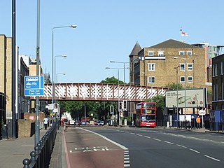
Commercial Road is a street in the London Borough of Tower Hamlets in the East End of London. It is 1.9 miles (3.1 km) long, running from Gardiner's Corner, through Stepney to the junction with Burdett Road in Limehouse at which point the route splits into the East India Dock Road and the West India Dock Road. It is an artery connecting the historic City of London with the more recently developed financial district at Canary Wharf, and part of the A13.

City Square is a paved area north of Leeds railway station at the junction of Park Row to the east and Wellington Street to the south. It is a triangular area where six roads meet: Infirmary Street and Park Row to the north, Boar Lane and Bishopsgate Street to the south-east, and Quebec Street and Wellington Street to the south-west. The only building with a direct frontage is the former General Post Office, on the north-west side.

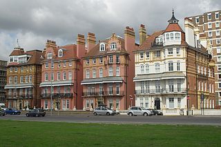
Richmond Green is a recreation area near the centre of Richmond, a town of about 20,000 inhabitants situated in south-west London. Owned by the Crown Estate, it is leased to the London Borough of Richmond upon Thames. The Green, which has been described as "one of the most beautiful urban greens surviving anywhere in England", is roughly square in shape and its open grassland, framed with broadleaf trees, extends to roughly twelve acres. On the north-east side there is also a smaller open space called Little Green. Richmond Green and Little Green are overlooked by a mixture of period townhouses, historic buildings and municipal and commercial establishments including the Richmond Lending Library and Richmond Theatre.

The A4200 is a major thoroughfare in central London. It runs between the A4 at Aldwych, to the A400 Hampstead Road/Camden High Street, at Mornington Crescent tube station, via Holborn, Bloomsbury, Euston and Somers Town.

Stamford Street is a street in Lambeth and Southwark, London, England, just south of the River Thames. It runs between Waterloo Road to the west and Blackfriars Road to the east. It forms part of the A3200.
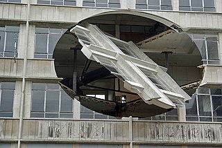
Richard Wilson is an English sculptor, installation artist and musician.
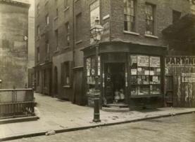
Clare Market is a historic area in central London located within the parish of St Clement Danes to the west of Lincoln's Inn Fields, between the Strand and Drury Lane, with Vere Street adjoining its western side. It was named after the food market which had been established in Clement's Inn Fields, by John Holles, 2nd Earl of Clare. Much of the area and its landmarks were immortalised by Charles Dickens in The Old Curiosity Shop, The Pickwick Papers, Barnaby Rudge and Sketches by Boz.

The Faraday Building is in the south-west of the City of London. The land was first acquired by the General Post Office in the 1870s, for the Post Office Savings Bank. In 1902 it was converted to a GPO telephone exchange serving sections of London, and underwent several capacity expansions over the next several years. The eastern extension of the building stands on the site of Doctors' Commons whose members had lower-courts say in ecclesiastical and admiralty matters.

Cavendish Square is a public garden square in Marylebone in the West End of London. It has a double-helix underground commercial car park. Its northern road forms ends of four streets: of Wigmore Street that runs to Portman Square in the much larger Portman Estate to the west; of Harley Street which runs an alike distance; of Chandos Street which runs for one block and; of Cavendish Place which runs the same. The south side itself is modern: the rear façade and accesses to a flagship department store and office block. On the ground floors facing are Comptoir Libanais, Royal Bank of Scotland and Pret a Manger premises.

Baynard House is a brutalist office block in Queen Victoria Street in Blackfriars in the City of London, occupied by BT Group. It was built on the site of Baynard's Castle. Most of the land under it is a scheduled monument. From 1982 to 1997 it housed the BT Museum.
As of February 2001, there were 1,124 listed buildings with Grade II status in the English city of Brighton and Hove. The total at 2009 was similar. The city, on the English Channel coast approximately 52 miles (84 km) south of London, was formed as a unitary authority in 1997 by the merger of the neighbouring towns of Brighton and Hove. Queen Elizabeth II granted city status in 2000.

Milford Lane is a narrow street in the City of Westminster that runs from Strand in the north to a brief walkway section leading to Temple Place in the south. It is joined by Little Essex Street and Essex Street on its eastern side. Maltravers Street once joined the lane to Arundel Street, but ceased to exist when building work at 190 Strand was completed.

Sardinia Street, formerly Duke Street was the northern continuation of Kemble Street. It ended, like its successor, on the west side (carriageway) of Lincoln's Inn Fields in the north, but further north. It was joined on its western side by King's Head Yard (demolished) and Wild Street, and opposite by Vere Street (demolished). On the eastern side at the northern end was a Roman Catholic chapel and chapel yard.

One Kemble Street and Civil Aviation Authority House, originally known jointly as Space House, is an architecturally notable building off Kingsway in the London Borough of Camden. It is a grade II listed building with Historic England. Like nearby Centre Point, it was built for the developer Harry Hyams as part of the 1960s commercial property boom and kept empty for several years after completion.
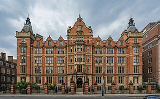
Sir Arthur Lewis Building is an Edwardian Grade II listed building on the National Heritage List for England, and an academic facility of the London School of Economics and Political Science (LSE), located on the south side of Lincoln's Inn Fields in Central London.

Regent Square is a public square and street in the London Borough of Camden in London, England. It is located near Kings Cross and Bloomsbury.

