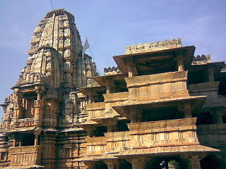
Vagad is a region in southeastern Rajasthan state of western India. Its boundaries are roughly defined by those of the districts of Dungarpur and Banswara. Major cities of the region are Dungarpur and Banswara.

Dungarpur District is a district of the state of Rajasthan in western India. The town of Dungarpur is the district headquarters.
Hussainpur is a census town in Jalandhar district in the Indian state of Punjab. It is situated in Jalandhar II Tehsil. The village code is 030405.
Meghraj is a town in the Indian state of Gujarat.
Obri is a panchayat village in Rajasthan in western India. Administratively it is under Sagwara Tehsil of Dungarpur district, Rajasthan. Obri is the only village in the gram panchayat.
Wagdi is a Bhil language of India spoken mainly in Dungarpur and Banswara districts of Southern Rajasthan. Wagdi has been characterized as a dialect of Bhili.

Akkiwat is a village in the southern state of Karnataka, India. It is located in the Hukeri taluk of Belgaum district in Karnataka. It is situated 23km away from sub-district headquarter Hukkeri and 58km apart from district headquarter Belgaum. As per 2009 stats, Kesthi is the gram panchayat of Akkiwat village.
Gudas, Belgaum is a village According to Census 2011 information the location code or village code of Gudas village is 597594. Gudas village is located in Hukeri taluka of Belgaum district in Karnataka, India. It is situated 11km away from sub-district headquarter Hukkeri and 63km away from district headquarter Belgaum. As per 2009 stats, Gudas village is also a gram panchayat.
Hattar Gunji is a village in khanapur Talukha and Belgaum district in the southern state of Karnataka, India. It comes under Hattar Gunji Panchayath. It belongs to Belgaum Division. Bharatiya Janata Party, BJP, Indian National Congress (INC), INC are the major political parties in this area.

Honnihalli is a village in Belagavi district in the southern state of Karnataka, India.
Shivanoor is a village in Belgaum district of Karnataka, India. According to Census 2011 information the location code or village code of Shivanoor village is 597265. Shivanoor village is located in Athni Tehsil of Belgaum district in Karnataka, India. It is situated 13km away from sub-district headquarter Athani and 167km away from district headquarter Belgaum. As per 2009 stats, Jambagi is the gram panchayat of Shivanoor village.
State Highway 10 is a State Highway in Rajasthan state of India that connects Swaroopganj in Sirohi district of Rajasthan with Ratlam in Ratlam district of Madhya Pradesh. The total length of RJ SH 10 is 315 km.
Madamanuru is a village located in Manubolu Tehsil of Nellore, Andhra Pradesh, India. According to Census 2011 information the location code or village code of Madamanuru village is 592198. It is situated 11km away from sub-district headquarter Manubolu and 37km away from district headquarter Nellore. As per 2009 stats, Madamanur is the gram panchayat of Madamanuru village.
Sagwara tehsil is one of five tehsils in Dungarpur District of Rajasthan, India. It is in the southeast part of the district and borders on the Mahi River. The town of Sagwara is the headquarters of the tehsil.
Bheeloora is a panchayat village in Rajasthan in western India. Administratively it is under Sagwara Tehsil of Dungarpur district, Rajasthan.
C.Ayyampalayam is a village located in the Manachanallur taluk of the Tiruchirappalli district of the Indian state Tamil Nadu. It is situated 5 km away from taluk headquarter Manachanallur and 20 km away from district headquarter Tiruchirappalli.
Tisotra is a village that is governed by Panchayat law in the Bijnor district of the Indian state of Uttar Pradesh. There is a Nootan Inter college in the village. The population as of 2011 was estimated at 3,921.
Bajajnagar is a census town in the Mavli tehsil of Udaipur district, Rajasthan, India. It is situated around 18km away from Mavli and 25km away from district headquarter Udaipur.
Sagwara is one of the 200 Legislative Assembly constituencies of Rajasthan state in India.
Vediya or Vedia is a village and Gram Panchayat in Ahore tehsil of Jalore District of Rajasthan state in India. It is situated 18km away from sub-district headquarter Ahore and 20km away from district headquarter Jalore. Vediya has a total population of 1,987 peoples according to Census 2011.


