Related Research Articles

A geographic information system (GIS) consists of integrated computer hardware and software that store, manage, analyze, edit, output, and visualize geographic data. Much of this often happens within a spatial database, however, this is not essential to meet the definition of a GIS. In a broader sense, one may consider such a system also to include human users and support staff, procedures and workflows, the body of knowledge of relevant concepts and methods, and institutional organizations.

Remote sensing is the acquisition of information about an object or phenomenon without making physical contact with the object, in contrast to in situ or on-site observation. The term is applied especially to acquiring information about Earth and other planets. Remote sensing is used in numerous fields, including geophysics, geography, land surveying and most Earth science disciplines. It also has military, intelligence, commercial, economic, planning, and humanitarian applications, among others.

A weather satellite or meteorological satellite is a type of Earth observation satellite that is primarily used to monitor the weather and climate of the Earth. Satellites can be polar orbiting, or geostationary.

The Landsat program is the longest-running enterprise for acquisition of satellite imagery of Earth. It is a joint NASA / USGS program. On 23 July 1972, the Earth Resources Technology Satellite was launched. This was eventually renamed to Landsat 1 in 1975. The most recent, Landsat 9, was launched on 27 September 2021.
The Moderate Resolution Imaging Spectroradiometer (MODIS) is a satellite-based sensor used for earth and climate measurements. There are two MODIS sensors in Earth orbit: one on board the Terra satellite, launched by NASA in 1999; and one on board the Aqua satellite, launched in 2002. MODIS has now been replaced by the VIIRS, which first launched in 2011 aboard the Suomi NPP satellite.
SPOT is a commercial high-resolution optical Earth imaging satellite system operating from space. It is run by Spot Image, based in Toulouse, France. It was initiated by the CNES in the 1970s and was developed in association with the SSTC and the Swedish National Space Board (SNSB). It has been designed to improve the knowledge and management of the Earth by exploring the Earth's resources, detecting and forecasting phenomena involving climatology and oceanography, and monitoring human activities and natural phenomena. The SPOT system includes a series of satellites and ground control resources for satellite control and programming, image production, and distribution. Earlier satellites were launched using the European Space Agency's Ariane 2, 3, and 4 rockets, while SPOT 6 and SPOT 7 were launched by the Indian PSLV.

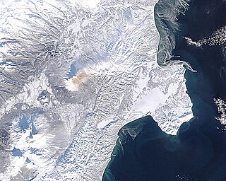
Satellite images are images of Earth collected by imaging satellites operated by governments and businesses around the world. Satellite imaging companies sell images by licensing them to governments and businesses such as Apple Maps and Google Maps.

Reuven Ramaty High Energy Solar Spectroscopic Imager was a NASA solar flare observatory. It was the sixth mission in the Small Explorer program (SMEX), selected in October 1997 and launched on 5 February 2002, at 20:58:12 UTC. Its primary mission was to explore the physics of particle acceleration and energy release in solar flares.

The Tropical Rainfall Measuring Mission (TRMM) was a joint space mission between NASA and JAXA designed to monitor and study tropical rainfall. The term refers to both the mission itself and the satellite that the mission used to collect data. TRMM was part of NASA's Mission to Planet Earth, a long-term, coordinated research effort to study the Earth as a global system. The satellite was launched on 27 November 1997 from the Tanegashima Space Center in Tanegashima, Japan. TRMM operated for 17 years, including several mission extensions, before being decommissioned on 15 April 2015. TRMM re-entered Earth's atmosphere on 16 June 2015.
Copernicus is the Earth observation component of the European Union Space Programme, managed by the European Commission and implemented in partnership with the EU Member States, the European Space Agency (ESA), the European Organisation for the Exploitation of Meteorological Satellites (EUMETSAT), the European Centre for Medium-Range Weather Forecasts (ECMWF), the Joint Research Centre (JRC), the European Environment Agency (EEA), the European Maritime Safety Agency (EMSA), Frontex, SatCen and Mercator Océan.
Indian National Center for Ocean Information Services (INCOIS) is an autonomous organization of the Government of India, under the Ministry of Earth Sciences, located in Pragathi Nagar, Hyderabad. ESSO-INCOIS was established as an autonomous body in 1998 under the Ministry of Earth Sciences (MoES) and is a unit of the Earth System Science Organization (ESSO). ESSO- INCOIS is mandated to provide the best possible ocean information and advisory services to society, industry, government agencies and the scientific community through sustained ocean observations and constant improvements through systematic and focussed research.

Sentinel-1 is the first of the Copernicus Programme satellite constellations conducted by the European Space Agency. The mission was originally composed of a constellation of two satellites, Sentinel-1A and Sentinel-1B, which shared the same orbital plane. Two more satellites, Sentinel-1C and Sentinel-1D are in development. Sentinel-1B was retired following a power supply issue on December 23, 2021, leaving Sentinel-1A the only satellite of the constellation currently operating. Sentinel-1C is currently planned to launch in the final quarter of 2024.

Sentinel-2 is an Earth observation mission from the Copernicus Programme that acquires optical imagery at high spatial resolution over land and coastal waters. The mission's Sentinel-2A and Sentinel-2B satellites are to be joined in orbit in 2024 by a third, Sentinel-2C.
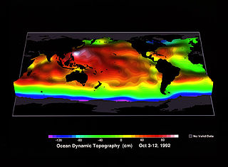
Ocean surface topography or sea surface topography, also called ocean dynamic topography, are highs and lows on the ocean surface, similar to the hills and valleys of Earth's land surface depicted on a topographic map. These variations are expressed in terms of average sea surface height (SSH) relative to Earth's geoid. The main purpose of measuring ocean surface topography is to understand the large-scale ocean circulation.
The Future of Marine Animal Populations (FMAP) project was one of the core projects of the international Census of Marine Life (2000–2010). FMAP's mission was to describe and synthesize globally changing patterns of species abundance, distribution, and diversity, and to model the effects of fishing, climate change and other key variables on those patterns. This work was done across ocean realms and with an emphasis on understanding past changes and predicting future scenarios.
A fire regime is the pattern, frequency, and intensity of the bushfires and wildfires that prevail in an area over long periods of time. It is an integral part of fire ecology, and renewal for certain types of ecosystems. A fire regime describes the spatial and temporal patterns and ecosystem impacts of fire on the landscape, and provides an integrative approach to identifying the impacts of fire at an ecosystem or landscape level. If fires are too frequent, plants may be killed before they have matured, or before they have set sufficient seed to ensure population recovery. If fires are too infrequent, plants may mature, senesce, and die without ever releasing their seed.

The Visible Infrared Imaging Radiometer Suite (VIIRS) is a sensor designed and manufactured by the Raytheon Company on board the polar-orbiting Suomi National Polar-orbiting Partnership, NOAA-20, and NOAA-21 weather satellites. VIIRS is one of five key instruments onboard Suomi NPP, launched on October 28, 2011. VIIRS is a whiskbroom scanner radiometer that collects imagery and radiometric measurements of the land, atmosphere, cryosphere, and oceans in the visible and infrared bands of the electromagnetic spectrum.

Ecosystem Functional Type (EFT) is an ecological concept to characterize ecosystem functioning. Ecosystem Functional Types are defined as groups of ecosystems or patches of the land surface that share similar dynamics of matter and energy exchanges between the biota and the physical environment. The EFT concept is analogous to the Plant Functional Types (PFTs) concept, but defined at a higher level of the biological organization. As plant species can be grouped according to common functional characteristics, ecosystems can be grouped according to their common functional behavior.

Land change models (LCMs) describe, project, and explain changes in and the dynamics of land use and land-cover. LCMs are a means of understanding ways that humans change the Earth's surface in the past, present, and future.
Remote sensing in oceanography is a widely used observational technique which enables researchers to acquire data of a location without physically measuring at that location. Remote sensing in oceanography mostly refers to measuring properties of the ocean surface with sensors on satellites or planes, which compose an image of captured electromagnetic radiation. A remote sensing instrument can either receive radiation from the Earth’s surface (passive), whether reflected from the Sun or emitted, or send out radiation to the surface and catch the reflection (active). All remote sensing instruments carry a sensor to capture the intensity of the radiation at specific wavelength windows, to retrieve a spectral signature for every location. The physical and chemical state of the surface determines the emissivity and reflectance for all bands in the electromagnetic spectrum, linking the measurements to physical properties of the surface. Unlike passive instruments, active remote sensing instruments also measure the two-way travel time of the signal; which is used to calculate the distance between the sensor and the imaged surface. Remote sensing satellites often carry other instruments which keep track of their location and measure atmospheric conditions.
References
- Petitjean, François; Gançarski, Pierre; Masseglia, Florent; Forestier, Germain (September 2010). "Analysing Satellite Image Time Series by Means of Pattern Mining". In Fyfe, Colin; Tino, Peter; Charles, Darryl; Garcia-Osorio, Cesar; Yin, Hujun (eds.). Intelligent Data Engineering and Automated Learning — IDEAL 2010: 11th International Conference (Proceedings). Vol. LNCS 6283. Springer-Verlag. pp. 45–52. ISBN 978-3-642-15380-8. OCLC 3719235.