Suldal is a municipality in the northeast corner of Rogaland county, Norway. It is located in the traditional district of Ryfylke. Since 1965, the administrative centre of Suldal is the village of Sand i Ryfylke. Other villages in Suldal include Hålandsosen, Jelsa, Marvik, Nesflaten, and Suldalsosen.

Etne is a municipality in Hordaland county, Norway. It is located in the traditional district of Sunnhordland, although it is also sometimes considered to be part of the district of Haugaland. The administrative centre of the municipality is the village of Etnesjøen. Other villages in the municipality include Skånevik and Fjæra. The two largest villages in the municipality are Etnesjøen with 1,159 residents and Skånevik with 594 residents.

Flekkefjord (help·info) is a municipality in Vest-Agder county, Norway. It is located in the traditional district of Lister. The administrative centre of the municipality is the town of Flekkefjord. The villages of Sira, Gyland, Rasvåg, Kirkehavn, and Åna-Sira are located in Flekkefjord.

Egersund is a town in Eigersund municipality in Rogaland county, Norway. The town is located along the southwestern coast of Norway, about 75 kilometres (47 mi) south of the city of Stavanger. The town is situated along a strait which separates the mainland from the island of Eigerøya. The 6.36-square-kilometre (1,570-acre) village has a population (2015) of 11,473 which gives the town a population density of 1,804 inhabitants per square kilometre (4,670/sq mi).

Haugaland or Haugalandet is a traditional district situated on the western coast of Norway. Haugaland is one of the 15 traditional districts located within the Vestlandet region.

Tau is a village in Strand municipality in Rogaland county, Norway. The village is located on the shore of the Horgefjorden, a branch of the main Boknafjorden. The 2.11-square-kilometre (520-acre) village has a population (2015) of 3,158 which gives the village a population density of 1,497 inhabitants per square kilometre (3,880/sq mi). Strand Church is located in the village.

Saudafjord or Saudafjorden is a fjord in Rogaland county, Norway. The fjord stretches from the town of Sauda in the municipality of Sauda in the north to the village of Sand in the municipality of Suldal where the Saudafjorden and Hylsfjorden join together to form the Sandsfjorden.

Brusand is a village in Hå municipality in Rogaland county, Norway. The small village is located on a small isthmus of land between the lake Bjåvatnet and the North Sea. The village sits along the Sørlandet Line and it is served by the Jæren Commuter Rail which stops at the Brusand Station. The village is about 4 kilometres (2.5 mi) southeast of the village of Vigrestad and about 5 kilometres (3.1 mi) northwest of the villages of Ogna and Sirevåg.

Hålandsmarka is a village in Sola municipality in Rogaland county, Norway. The village is located in the southwestern part of the municipality, about 1 kilometre (0.62 mi) west of the village of Stenebyen. Hålandsmarka is known for a great seaside view of most of the Rogaland coastline, on good days you will be able to see areas as far as 70 kilometres (43 mi) away.

Hellandsbygda or Hellandsbygd is a village in Sauda municipality in Rogaland county, Norway. The village is located in a river valley about 12 kilometres (7.5 mi) northeast of the town of Sauda. The village is surrounded by forested mountains with the County Road 520 running through the village on its way from Sauda over the mountains to the Røldal area in neighboring Hordaland county. The mountain Kyrkjenuten lies to the north of Hellandsbygda and the mountain Skaulen lies to the southeast of the village.

Sogndalsstranda or Sogndalstrand is a harbor village in Sokndal municipality in Rogaland county, Norway. The village is located at the mouth of the river Sokno, about 2 kilometres (1.2 mi) south of the municipal centre of Hauge and also about 2 kilometres (1.2 mi) southeast of the village of Rekefjord. The Jøssingfjorden lies about 2.7 kilometres (1.7 mi) southeast of the village.

Amdal is a small farming village in Sauda municipality in Rogaland county, Norway. The village is located just a short distance inland from the Saudafjorden, about 1.5 kilometres (0.93 mi) north of the village of Saudasjøen and about 2.5 kilometres (1.6 mi) west of the town of Sauda.

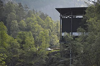
Allmannajuvet is a ravine or canyon located along the river Storelva in the municipality of Sauda in Rogaland county, Norway. The ravine is located in a rural, forested area along the Norwegian County Road 520 between the town of Sauda and the village of Hellandsbygda.

Sauda Church is the main parish church in Sauda municipality in Rogaland county, Norway. It is located in the town of Sauda. The church is part of the Sauda parish in the Ryfylke deanery in the Diocese of Stavanger.

Saudasjøen Chapel is a chapel in Sauda in Rogaland county, Norway. It is located in the village of Saudasjøen. The chapel is part of the Sauda parish in the Ryfylke deanery in the Diocese of Stavanger. The concrete chapel was built in 1973 and it seats about 300 people.


