Saudasjøen

Last updated
Saudasjøen
Village
Norway Rogaland location map.svg
Red pog.svg
Saudasjøen
Location in Rogaland county
Norway location map.svg
Red pog.svg
Saudasjøen
Saudasjøen (Norway)
Coordinates: 59°38′17″N06°18′11″E / 59.63806°N 6.30306°E / 59.63806; 6.30306 Coordinates: 59°38′17″N06°18′11″E / 59.63806°N 6.30306°E / 59.63806; 6.30306
Country Norway
Region Western Norway
County Rogaland
District Ryfylke
Municipality Sauda
Elevation [1] 23 m (75 ft)
Time zone CET (UTC+01:00)
  Summer (DST) CEST (UTC+02:00)
Post Code4208 Saudasjøen

Saudasjøen is a village in Sauda municipality in Rogaland county, Norway. The village is located along the northern coast of the Saudafjorden about 3.5 kilometres (2.2 mi) southwest of the town of Sauda. For statistical purposes it is considered a part of the urban area of the town of Sauda. The village is mostly a bedroom community for the nearby town of Sauda. There are some small industries in Saudasjøen as well as the Saudasjøen Chapel. County Road 520 runs through the village along the shore of the fjord. [2]

Sauda Municipality in Rogaland, Norway

Sauda(listen ) is a municipality and industrial town in Rogaland county, Norway. The administrative centre of the municipality is the town of Sauda, where most of the population lives. Other villages in the municipality include Saudasjøen and Amdal. Despite being in the northern part of the region of Ryfylke, Sauda participates in the Haugalandet Council and is under the jurisdiction of the Haugaland District Court.

Rogaland County (fylke) of Norway

Rogaland[²ruːɡɑlɑn](listen) is a county in Western Norway, bordering Hordaland, Telemark, Aust-Agder, and Vest-Agder counties. Rogaland is the center of the Norwegian petroleum industry. In 2016, Rogaland had an unemployment rate of 4.9%, one of the highest in Norway. In 2015, Rogaland had a fertility rate of 1.78 children per woman, which is the highest in the country.

Norway constitutional monarchy in Northern Europe

Norway, officially the Kingdom of Norway, is a Nordic country in Northwestern Europe whose territory comprises the western and northernmost portion of the Scandinavian Peninsula; the remote island of Jan Mayen and the archipelago of Svalbard are also part of the Kingdom of Norway. The Antarctic Peter I Island and the sub-Antarctic Bouvet Island are dependent territories and thus not considered part of the kingdom. Norway also lays claim to a section of Antarctica known as Queen Maud Land.

History

Historically, Saudasjøen arose as a seaside resort near the small farm of Sauda and it became industrialized in the 1800s. The municipality was incorporated in 1838 and the village of Saudasjøen became its administrative centre (a position it held until the early 1900s when it was moved to Sauda. The small village is an important industrial location, especially in the field of metallurgy. Merchants settled around the quay at the old seaside resort and there were also a number of hotels and cafes in the area including the Sauda Fjordhotel and the Sauda Skisenter. The municipal high school was located here until 1989.

A seaside resort is a resort town or resort village, or resort hotel, located on the coast. Sometimes it is also an officially accredited title, that is only awarded to a town when the requirements are met. Where a beach is the primary focus for tourists, it may be called a beach resort.

An administrative centre is a seat of regional administration or local government, or a county town, or the place where the central administration of a commune is located.

Sauda (town) Town in Western Norway, Norway

Sauda is a town in Sauda municipality in Rogaland county, Norway. The town, which is also the administrative centre of the municipality, is located in a river valley at the northern end of the Saudafjorden. The small suburb of Saudasjøen lies about 3 kilometres (1.9 mi) west of the town centre. A large part of the industrial harbour area of Sauda is built on reclaimed land that was once underwater in the fjord.

During World War II there was built a large aluminum plant at Nesøyra but production was moved to Årdal in 1947. The glass production factory Si-Glass was also located at Nesøyra. Saudasjøen is the site of the cemetery with Russian graves from World War II.

Årdal Municipality in Sogn og Fjordane, Norway

Årdal is a municipality in Sogn og Fjordane county, Norway. It is located at the end of the Årdalsfjorden in the traditional district of Sogn. The village of Årdalstangen is the administrative center of the municipality. The other main village is Øvre Årdal. The municipality of Årdal was created in 1860 when it was separated from the municipality of Lærdal.

Related Research Articles

Suldal Municipality in Rogaland, Norway

Suldal is a municipality in the northeast corner of Rogaland county, Norway. It is located in the traditional district of Ryfylke. Since 1965, the administrative centre of Suldal is the village of Sand i Ryfylke. Other villages in Suldal include Hålandsosen, Jelsa, Marvik, Nesflaten, and Suldalsosen.

Etne Municipality in Hordaland, Norway

Etne is a municipality in Hordaland county, Norway. It is located in the traditional district of Sunnhordland, although it is also sometimes considered to be part of the district of Haugaland. The administrative centre of the municipality is the village of Etnesjøen. Other villages in the municipality include Skånevik and Fjæra. The two largest villages in the municipality are Etnesjøen with 1,159 residents and Skånevik with 594 residents.

Flekkefjord Municipality in Vest-Agder, Norway

Flekkefjord  is a municipality in Vest-Agder county, Norway. It is located in the traditional district of Lister. The administrative centre of the municipality is the town of Flekkefjord. The villages of Sira, Gyland, Rasvåg, Kirkehavn, and Åna-Sira are located in Flekkefjord.

Egersund Town in Western Norway, Norway

Egersund is a town in Eigersund municipality in Rogaland county, Norway. The town is located along the southwestern coast of Norway, about 75 kilometres (47 mi) south of the city of Stavanger. The town is situated along a strait which separates the mainland from the island of Eigerøya. The 6.36-square-kilometre (1,570-acre) village has a population (2015) of 11,473 which gives the town a population density of 1,804 inhabitants per square kilometre (4,670/sq mi).

Haugaland District in Rogaland and Hordaland, Norway

Haugaland or Haugalandet is a traditional district situated on the western coast of Norway. Haugaland is one of the 15 traditional districts located within the Vestlandet region.

Tau, Norway Village in Western Norway, Norway

Tau is a village in Strand municipality in Rogaland county, Norway. The village is located on the shore of the Horgefjorden, a branch of the main Boknafjorden. The 2.11-square-kilometre (520-acre) village has a population (2015) of 3,158 which gives the village a population density of 1,497 inhabitants per square kilometre (3,880/sq mi). Strand Church is located in the village.

Saudafjord

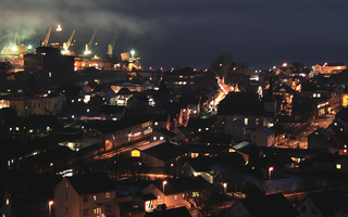
Saudafjord or Saudafjorden is a fjord in Rogaland county, Norway. The fjord stretches from the town of Sauda in the municipality of Sauda in the north to the village of Sand in the municipality of Suldal where the Saudafjorden and Hylsfjorden join together to form the Sandsfjorden.

Brusand Village in Western Norway, Norway

Brusand is a village in Hå municipality in Rogaland county, Norway. The small village is located on a small isthmus of land between the lake Bjåvatnet and the North Sea. The village sits along the Sørlandet Line and it is served by the Jæren Commuter Rail which stops at the Brusand Station. The village is about 4 kilometres (2.5 mi) southeast of the village of Vigrestad and about 5 kilometres (3.1 mi) northwest of the villages of Ogna and Sirevåg.

Hålandsmarka Village in Western Norway, Norway

Hålandsmarka is a village in Sola municipality in Rogaland county, Norway. The village is located in the southwestern part of the municipality, about 1 kilometre (0.62 mi) west of the village of Stenebyen. Hålandsmarka is known for a great seaside view of most of the Rogaland coastline, on good days you will be able to see areas as far as 70 kilometres (43 mi) away.

Hellandsbygd Village in Western Norway, Norway

Hellandsbygda or Hellandsbygd is a village in Sauda municipality in Rogaland county, Norway. The village is located in a river valley about 12 kilometres (7.5 mi) northeast of the town of Sauda. The village is surrounded by forested mountains with the County Road 520 running through the village on its way from Sauda over the mountains to the Røldal area in neighboring Hordaland county. The mountain Kyrkjenuten lies to the north of Hellandsbygda and the mountain Skaulen lies to the southeast of the village.

Sogndalstrand Village in Western Norway, Norway

Sogndalsstranda or Sogndalstrand is a harbor village in Sokndal municipality in Rogaland county, Norway. The village is located at the mouth of the river Sokno, about 2 kilometres (1.2 mi) south of the municipal centre of Hauge and also about 2 kilometres (1.2 mi) southeast of the village of Rekefjord. The Jøssingfjorden lies about 2.7 kilometres (1.7 mi) southeast of the village.

Amdal Village in Western Norway, Norway

Amdal is a small farming village in Sauda municipality in Rogaland county, Norway. The village is located just a short distance inland from the Saudafjorden, about 1.5 kilometres (0.93 mi) north of the village of Saudasjøen and about 2.5 kilometres (1.6 mi) west of the town of Sauda.

Allmannajuvet

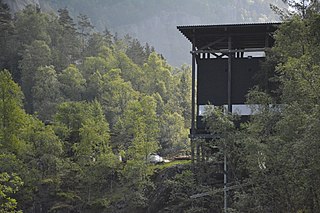
Allmannajuvet is a ravine or canyon located along the river Storelva in the municipality of Sauda in Rogaland county, Norway. The ravine is located in a rural, forested area along the Norwegian County Road 520 between the town of Sauda and the village of Hellandsbygda.

Sauda may refer to:

Sauda Church Church in Rogaland, Norway

Sauda Church is the main parish church in Sauda municipality in Rogaland county, Norway. It is located in the town of Sauda. The church is part of the Sauda parish in the Ryfylke deanery in the Diocese of Stavanger.

Saudasjøen Chapel Church in Rogaland, Norway

Saudasjøen Chapel is a chapel in Sauda in Rogaland county, Norway. It is located in the village of Saudasjøen. The chapel is part of the Sauda parish in the Ryfylke deanery in the Diocese of Stavanger. The concrete chapel was built in 1973 and it seats about 300 people.

References

  1. "Saudasjøen, Sauda (Rogaland)" (in Norwegian). yr.no . Retrieved 2015-05-06.
  2. Store norske leksikon. "Saudasjøen" (in Norwegian). Retrieved 2015-05-06.