
Kane County is a county in the U.S. state of Illinois. According to the 2020 census, it has a population of 516,522, making it the fifth-most populous county in Illinois. Its county seat is Geneva, and its largest city is Aurora. Kane County is one of the collar counties of the metropolitan statistical area designated "Chicago–Naperville–Elgin, IL–IN–WI" by the US census.
Summit Metro Parks is a Metroparks system serving the citizens of Summit County, Ohio by managing 14,000 acres (5,700 ha) in 16 developed parks, six conservation areas and more than 150 miles (240 km) of trails, with 22.4 miles (36.0 km) of the Ohio & Erie Canal Towpath Trail.

The Forest Preserve District of Cook County is a governmental commission in Cook County, Illinois, that owns and manages land containing forest, prairie, wetland, streams, and lakes. These land holdings are primarily managed as undeveloped natural areas and for outdoor recreation. The Forest Preserve District encompasses approximately 70,000 acres of land or approximately 11% of the land in Cook County, which contains the city of Chicago and is the most densely populated urban metropolitan area in the Midwest. The Forest Preserves also owns the lands on which the Brookfield Zoo and the Chicago Botanic Garden operate. The Cook County Board of Commissioners also serves ex-officio as the board for the district. The Forest Preserve District headquarters is located in River Forest, Illinois.

Stony Kill Falls is the site of one of many access points to the Delaware Aqueduct. It is located in the town of Wawarsing, on the northwestern edge of the Minnewaska Preserve on land acquired in 2001 by the State of New York, The Open Space Institute and the New York-New Jersey Trail Conference from Napanoch Sand and Gravel Company that once owned the land. Long a little known back entrance into the Minnewaska Preserve, utilized by curiosity seekers and more experienced mountaineers, as a more convenient access point to Stony Kill Falls. The area only provides access to Stony Kill Falls, no other trails are allowed to be accessed from this area. Parking is limited, no parking is permitted on town roads please respect the neighbors and stay off private property.
The Ned Brown Forest Preserve, popularly known as Busse Woods, adjoining Rolling Meadows, Elk Grove Village and Schaumburg in Illinois, is a 3,700-acre (1,500 ha) unit of the Cook County Forest Preserve system. It is named after Edward "Ned" Eagle Brown. A section of the northeast quadrant of the forest preserve is the Busse Forest Nature Preserve, which was registered as a National Natural Landmark in February 1980. Busse Forest Preserve was named for Cook County Commissioner William Busse in 1949.

White Pines Forest State Park, more commonly referred to as White Pines State Park, is an Illinois state park in Ogle County, Illinois. It is located near the communities of Polo, Mount Morris and Oregon. The 385-acre (156 ha) park contains the southernmost remaining stand of native white pine trees in the state of Illinois, and that area, 43 acres (17 ha), was designated an Illinois Nature Preserve in 2001.

Bloom Township is one of 29 townships in Cook County, Illinois, USA. As of the 2020 census, its population was 86,018 and it contained 33,964 housing units.

Lyons Township is one of 29 townships in Cook County, Illinois. As of the 2020 census, its population was 115,105, with its most populous municipalities including La Grange, Justice and Summit. Lyons Township was established in 1850. The village of Lyons, almost all of which lies within the township, is often confused with it.
Elfin Forest is an unincorporated residential community of San Diego County, California, United States, in the foothills of the Santa Rosa Mountains. The community is southwest of Escondido and according to the USGS it is located at 33°04′25″N117°09′51″W in the Escondido ZIP code of 92029. It borders the rural, unincorporated town of Harmony Grove to the northeast, San Marcos to the north and west, Olivenhain to the southwest, and Rancho Santa Fe to the south.
The Toronto ravine system is a distinctive feature of the city's geography, consisting of a network of deep ravines, which forms a large urban forest that runs through most of Toronto. The ravine system is the largest in any city in the world, with the Ravine and Natural Feature Protection Bylaw protecting approximately 110 square kilometres (42 sq mi) of public and privately-owned land. The ravine system has been presented as a central characteristic of the city, with the size of the ravine system leading Toronto to be described as "a city within a park".
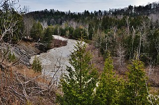
Thorn Creek is a 20.8-mile-long (33.5 km) tributary of the Little Calumet River that travels through Will and Cook counties in northeastern Illinois just south of Chicago. It starts in the high land of the Valparaiso Moraine before dropping 200 feet (60 m) to the lower elevations of the Little Calumet River valley. Along its path it has cut many deep ravines and valleys. It is usually quite narrow, though the width of the river varies. Under 26th Street in Chicago Heights, a dam built in 1928 forms Sauk Lake, but just north of the street it is just a few feet across. This dam creates an accumulation of several feet of silt in Sauk Lake and is being considered for Notching in 2016 by the Corps of Engineers. The intent is to 'improve stream habitat'. The impact upon Ground Water Recharge, mitigation of Thorn Creek's 'flashiness' and future recreational activities are also concerns of Water-Shed Stakeholders.
The North Creek Woods or North Creek Meadow is located within the Cook County Forest Preserves in Lansing, Illinois. The woods are connected to the other forest preserves of the Thorn Creek Trailsystem. They are named after North Creek, a tributary of Thorn Creek that runs through the woods. They contain many miles of paved bike trails and off-trail dirt hiking paths. They are a popular place for runners, cyclists, and walkers during the warm and cold times of the year. North Creek Woods contains both dense forest and prairie shrubland. The bicycle trails go through both. There is also a pavilion located at the main parking lot on Glenwood-Lansing Road. The woods are mostly flat.
Goodenow Grove Nature Preserve is a unit of the Forest Preserve District of Will County located in Crete Township in Will County, Illinois. The closest town is Crete, Illinois. The preserve covers 898 acres (3.63 km2) and contains 4 miles (6.4 km) of trails and a man-made 40-foot (12 m) hill which is a sledding hill in the winter.
Sauk Lake is a small, freshwater lake located in Cook County, Illinois, between the municipalities of Park Forest, Illinois and Chicago Heights, Illinois. It is an enlarged portion of Thorn Creek created by a dam on the south side of 26th Street, which borders the lake to the north. It is surrounded by steep, sandy bluffs on the east and west sides. It lies within the Sauk Trail Woods Forest Preserve.
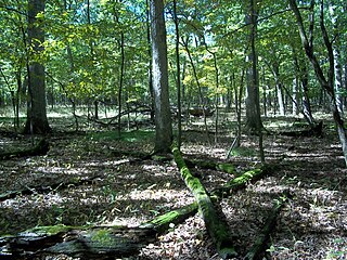
Thorn Creek Woods Nature Center and Preserve is located in Will County, Illinois, near the municipality of Park Forest, Illinois. It is part of the Forest Preserve District of Will County. The entranceway to Thorn Creek Woods Nature Preserve is located at 247 Monee Road, approximately 0.25-mile (400 m) north of Stunkel Road, in Park Forest. The preserve is open 8:00 a.m. - dusk daily; the Nature Center is open 12:00 - 4:00 p.m. Friday- Sunday. At 830 acres (3.4 km2), Thorn Creek Nature Preserve lies at the headwaters of Thorn Creek and consists of bottomlands, ravines, and white-oak forests interspersed with marsh and meadows. The actual nature center is located inside of an old church right off Monee Road. It is two stories and contains a nature library and nature exhibits. The trail starts behind the church and heads east into the woods. The topography varies. The trail starts off on high land before dropping down into the Thorn Creek River Valley. It then crosses the creek and goes up and out of the valley, again. The terrain is pretty rugged, especially near the river and its tributaries, because they have cut many gorges and ravines.
The North Branch Trail is a Class I bicycle trail located in northeastern Cook County, Illinois. The trail starts at the western part of Gompers Park in Chicago, and from there it continues north approximately 22 miles (35 km) to Glencoe. The trail follows a path along the North Branch of the Chicago River, the Skokie River and the Skokie Lagoons.

Waterfall Glen is a forest preserve in Downers Grove Township, DuPage County, Illinois, between the towns of Darien and Lemont, covering 2,492 acres (1,008 ha). It contains several waterfalls on Sawmill Creek as it empties into the Des Plaines River. Rocky Glen Falls, the largest waterfall in the preserve, is actually a natural dam in the valley glen. In the 1930s, the Civilian Conservation Corps helped restore the waterfall to its naturally tiered state, after years of erosion due to runoff from a nearby mill. It completely surrounds Argonne National Laboratory. It is also home to a popular model airplane field, located in the southwest section of the forest preserve. Hikers can also make the interior trip to St. Patrick Cemetery nestled deep in the preserve. Waterfall Glen's tallgrass prairies, bogs, and Midwestern oak savannas contain 740 native plant species, 75 percent of all the plants known to grow naturally in DuPage County. Over 300 species of mammals, birds, fish, amphibians, and reptiles and another 300 species of invertebrates use the forest preserve, either year-round or during their migrations.
The Forest Preserve District of Will County was created by referendum on July 25, 1927, to preserve open spaces in Will County, Illinois, US. The first land acquisition was in 1930. As of December 2010, the District owns or manages 21,916 acres (8,869 ha) of land. Current Will County board members make up a board of commissioners, which oversees the affairs of the Forest Preserve District.

Heberly Run is a tributary of East Branch Fishing Creek in Sullivan County, Pennsylvania, in the United States. It is approximately 4.9 miles (7.9 km) long and flows through Davidson Township. The watershed of the stream has an area of 6.42 square miles (16.6 km2). Its tributaries include Quinn Run and Meeker Run. The stream also has a number of waterfalls. It is partly in Pennsylvania State Game Lands Number 13. The forests near the stream largely consist of second-growth woods.