Okolona is a former census-designated place (CDP) in southern Louisville/Jefferson County, Kentucky, United States. It is centered on the intersection of Preston Highway and the Outer Loop. The population was 17,807 at the 2000 census. When the government of Jefferson County merged with the city of Louisville, Kentucky in 2003, residents of Okolona also became citizens of Louisville Metro. As a result, Okolona is said to be a neighborhood within the city limits of Louisville.
St. Joseph is a neighborhood two miles south of downtown Louisville, Kentucky, United States, and immediately east of the University of Louisville. It borders the Meriwether neighborhood to the north and Schnitzelburg to the east. The area was named after the St. Joseph's Infirmary hospital, which was established by the Sisters of Charity of Nazareth. The building, once located at the corner of Preston Street and Eastern Parkway, was razed in 1980.

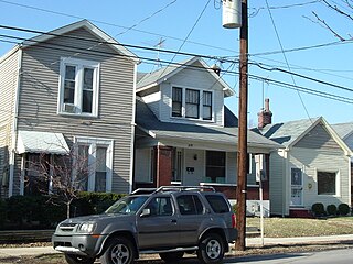
Meriwether is a neighborhood two miles southeast of downtown Louisville, Kentucky, USA, and just east of the University of Louisville. It was laid out by David Meriwether in 1871 and the first houses were built in 1891. Nearly all of the homes are shotgun houses.

Shelby Park is a neighborhood two miles southeast of downtown Louisville, Kentucky, USA, named after Kentucky's first governor, Isaac Shelby. Shelby Park has always been considered a working-class neighborhood. It was first populated by German immigrants in the early 1900s. By the 1950s, the neighborhood was majority African-American. Today, Shelby Park is a blend of ethnic and economic diversity. People from all walks of life co-exist in a vibrant, art-filled community.
Clifton Heights is a neighborhood two miles east of downtown Louisville, Kentucky USA. It was named because of its hilly location atop a ridge about 100 feet above the Ohio River floodplain, overlooking the adjacent community of Clifton. Though first planned in the 1890s as Summit Park, actual growth didn't begin until after World War I when automobiles made the hilly area accessible. Clifton Heights has had an African American presence since its founding, in 2000 they accounted for 21% of the population. Housing stock includes a variety of styles and time frames, from older shotgun houses and bungalows to suburban ranch homes built in the 1970s.
Audubon is a neighborhood in Louisville, Kentucky, United States. Its boundaries are Clarks Lane to the north, Poplar Level Road to the east, Preston Highway to the west, and the city of Audubon Park to the south. The smaller city of Parkway Village is surrounded by Audubon. George Rogers Clark Park, the site of a cabin owned by the parents of George Rogers Clark, is a prominent feature of the neighborhood.
Hayfield-Dundee is a neighborhood in eastern Louisville, Kentucky. Its boundaries are Dundee Road, Emerson Avenue, Newburg Road, I-264, and Tremont Drive to the east. Prior to subdivision, much of the land had been part of the Hayfield Farm, owned by Dr. Charles Wilkens Short, a founding professor of the University of Louisville medical school.
Gardiner Lane is a neighborhood in eastern Louisville, Kentucky, United States. Its boundaries are Emerson Avenue to the north, Bardstown Road to the east, I-264 to the south, and Tremont Drive to the west. As with surrounding neighborhoods, it was farmland well into the first half of the 1900s. 16 subdivisions were developed from 1913 to 1950.
Brownsboro-Zorn is a neighborhood in northeast Louisville, Kentucky, United States. Its boundaries are Brownsboro Road to the south, Birchwood Avenue to the west, Mellwood Avenue to the north, and Mockingbird Valley to the east. Residential development began in 1911 between Birchwood and Zorn Avenue, a wide street which bisects the neighborhood. The core of the neighborhood is residential, but there is substantial commerce along Brownsboro Road. The Veterans Affairs Medical Center is located along Zorn.
Bradley is a neighborhood two miles southeast of downtown Louisville, Kentucky, United States, and immediately east of the University of Louisville. The housing stock is mostly brick exterior craftsman style homes. Its boundaries are Eastern Parkway, Preston Highway, the Norfolk Southern Railway tracks, and I-65.
Prestonia is a neighborhood five miles southeast of downtown Louisville, Kentucky, U.S. Its boundaries are Preston Highway, Interstate 65, Interstate 264 and the Norfolk Southern Railway tracks. Many of Prestonia's streets are named after Kentucky counties. It was probably named for the local highway, which was in turn named after early Louisville landowner Col. William Preston.
O'Bannon is a neighborhood of Louisville, Kentucky centered along Old LaGrange Road and Collins Lane. O'Bannon was originally called Williamson after its first postmaster John Williamson, but was renamed in 1859 after postmaster John O'Bannon. The Post Office was located at the southwest corner of Old LaGrange Road and Collins Lane. O'Bannon Elementary School, which was located on Factory Lane, closed in 1960.

Seneca High School MCA is a Louisville, Kentucky, USA, public school. It is located at 3510 Goldsmith Lane, Louisville, Kentucky 40220, in the Hikes Point neighborhood and is part of Jefferson County Public Schools. Seneca is one of 15 Academies of Louisville schools in JCPS.
Butler Traditional High School is a high school in Louisville, Kentucky, United States.
Holy Angels Academy is a private, co-educational, Roman Catholic grade school and high school in Louisville, Kentucky within the Archdiocese of Louisville. Holy Angels Academy is located at 12201 Old Henry Road, Middletown, KY.
The Louisville Academy of Music is a non-profit community music school in Louisville, Kentucky in the Crescent Hill neighborhood. Founded in 1954 by Robert French and Donald Murray, the academy has given over a million music lessons. It originally operated from three rented rooms in Highlands area of Louisville and moved to its current location in 1971.
Sullivan College of Technology and Design was a private, technology-based for-profit career college in Louisville, Kentucky that was originally known as Louisville Technical Institute. It was renamed on June 29, 2009.
Louisville Classical Academy (LCA) is a nonsectarian, independent school from kindergarten through to grade eight. The school is located in the highlands neighborhood of Louisville, Kentucky. The school provides a classical liberal arts education through the disciplines of literature, Latin, Greek, mathematics, and music.

Western High SchoolEarly College is a public school in Louisville, Kentucky and is one of 22 high schools in Jefferson County Public Schools. The school offers programs that include: Early College, Culinary Arts, Geographic Information Systems (GIS), Help Desk, A+ certification, and Network+.
The New Albany-Floyd County Consolidated School Corporation (NAFCS) is a school district serving New Albany and Floyd County in Indiana, in the Louisville metropolitan area. The district headquarters are in New Albany.
