
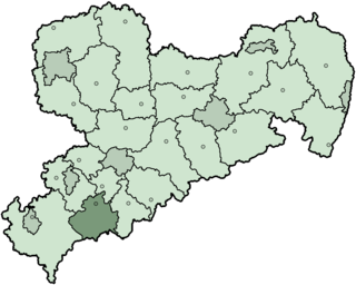
Annaberg is a former district in Saxony, Germany. It was bounded by the Czech Republic and the districts of Aue-Schwarzenberg, Stollberg and Mittlerer Erzgebirgskreis. Its colors are pink, green, and blue.

The Ore Mountains lie along the Czech–German border, separating the historical regions of Bohemia in the Czech Republic and Saxony in Germany. The highest peaks are the Klínovec in the Czech Republic at 1,244 metres (4,081 ft) above sea level and the Fichtelberg in Germany at 1,215 metres (3,986 ft).
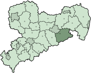
Aue-Schwarzenberg is a former district in Saxony, Germany. It was bounded by the Czech Republic and the districts of Vogtlandkreis, Zwickauer Land, Stollberg and Annaberg.
Hof is a Landkreis (district) in Bavaria, Germany. It is bounded by the districts of Wunsiedel, Bayreuth, Kulmbach and Kronach, the states of Thuringia and Saxony, and the Czech Republic. The city of Hof is an enclave within the district, as well as being the district's administrative seat.
The Sächsische Schweiz is a former district (Kreis) in the south of Saxony, Germany. Neighboring districts were Weißeritzkreis, the district-free city Dresden and the districts Kamenz and Bautzen. To the south it borders the Czech Republic.

Saxon Switzerland is a hilly climbing area and national park in the Elbe Sandstone Mountains. It is located around the Elbe valley south-east of Dresden in Saxony, Germany, adjoining Bohemian Switzerland in the Czech Republic. Together with the Czech part, the region is known as Saxon-Bohemian Switzerland.

The Fichtelberg is a mountain with two main peaks in the middle of the Ore Mountains in the east German state of Saxony, near the Czech border. At 1,214.6 m (3,985 ft) above sea level, the Fichtelberg is the highest mountain in Saxony, the second highest in the Ore Mountains and used to be the highest mountain in East Germany. Its subpeak is 1,206 m (3,957 ft) high.

Boží Dar is a town in Karlovy Vary District in the Karlovy Vary Region of the Czech Republic. It has about 300 inhabitants. Situated in the Ore Mountains at 1,028 m (3,373 ft) above sea level, it is considered the highest town in the Czech Republic. The town is part of the Abertamy – Boží Dar Mining Landscape, which is a UNESCO World Heritage Site as part of Ore Mountain Mining Region.
Erzgebirgskreis is a district (Kreis) in the Free State of Saxony, Germany. It is named after the Ore Mountains, a mountain range in the southern part of the district which forms part of the Germany–Czech Republic border. It borders the districts of Vogtlandkreis and Zwickau, the urban district Chemnitz, the district Mittelsachsen and the Czech Republic.
Mittelsachsen is a district (Kreis) in the Free State of Saxony, Germany.
Saxon Switzerland-Eastern Ore Mountains is a district (Kreis) in Saxony, Germany. It is named after the mountain ranges Saxon Switzerland and Eastern Ore Mountains.

The Aschberg is a mountain on the border of Germany (Saxony) and the Czech Republic. It is part of the Ore Mountains. The summit lies on the Czech side, in the municipality of Bublava.

The Eastern Ore Mountains form a natural region of Saxony that covers the eastern part of the Saxon Ore Mountains range. Together with the Western and Central Ore Mountains, it is part of the larger Saxon Highlands and Uplands region. Its southern continuation beyond the German border covers an area of roughly the same extent in the Czech Republic.
The Western Ore Mountains is a natural region that forms the westernmost part of the Ore Mountains in the German state of Saxony. It is also part of the major landscape unit known as the Saxon Highlands and Uplands. It extends eastwards to include the valley of the Schwarzwasser, and, below its mouth, that of the Zwickauer Mulde, and incorporates the western parts of the former major units known as the Lower and Upper Western Ore Mountains, no. 423, as well as the Southern Slopes of the Ore Mountains, no. 420.

The Georgenfelder Hochmoor is a raised bog (Hochmoor) in the German Ore Mountains of central Europe, not far from Zinnwald-Georgenfeld. It is part of a larger bog or moor complex, that lies to the south, mainly on the far side of the Germany's national border in the Czech Republic and which, since time immemorial, has been known simply as "The Lake". The Georgenfelder Hochmoor is one of the oldest nature reserves in Saxony.
The Schattenberg is a wooded mountain southwest of Jugel and northeast of Hirschenstand (Jelení) in the western Bohemian Ore Mountains, which is 950 metres high. East of the mountain lies the 980-metre-high Scheffelsberg and to the north is the 973-metre-high Buchschachtelberg. These three mountains form the main crest in this part of the Ore Mountains.
The Buchschachtelberg is a forested mountain south of Henneberg in the western Saxon Ore Mountains, which is 973 metres high. The border between Germany and the Czech Republic runs over its summit.
Jugel is a division of the town of Johanngeorgenstadt in the German district of Erzgebirgskreis. This dispersed settlement is surrounded by woods, is divided into Ober- and Unterjugel and runs along the German-Czech border from the Lehmergrund to the crest of the Western Ore Mountains. In the vicinity lies the 980 metre-high Scheffelsberg. Jugel is a tourist destination for hikers and winter sportsmen.

Satzung is a village in the Saxon municipality of Marienberg, which is in the district of Erzgebirgskreis in the German Ore Mountains.
The Buchkamm, wrongly also called the Buchkamp, is a forested ridge south of Oberwildenthal in the western Saxon Ore Mountains of Germany. Its highest point is 951 metres above sea level and it runs from southwest to northeast, not far from the Czech border. The old Reichsstraße 93 from Leipzig, which makes its way over the Hirschenstander Pass to Karlsbad, runs past the foot of the Buchkamm by the Nasse Bridge. Today it is only used as a forest road. Until the 1990s there was also a royal Saxon milestone here. An old smuggler's path, the Butter Way (Butterweg), runs past the Buchkamm to the southeast. It was used to smuggle butter and other goods between Bohemia and Saxony. It is now a hiking trail.
