The County Palatine of the Rhine, later the Electorate of the Palatinate or simply Electoral Palatinate, was a territory in the Holy Roman Empire administered by the Count Palatine of the Rhine. Its rulers served as prince-electors (Kurfürsten) from time immemorial, were noted as such in a papal letter of 1261, and were confirmed as electors by the Golden Bull of 1356.
The Palatinate, historically also Rhenish Palatinate, is a region in southwestern Germany. It occupies roughly the southernmost quarter of the German federal state of Rhineland-Palatinate (Rheinland-Pfalz), covering an area of 5,451 square kilometres (2,105 sq mi) with about 1.4 million inhabitants. Its residents are known as Palatines.

Maximilian II reigned as King of Bavaria between 1848 and 1864.

The Rhön Mountains are a group of low mountains in central Germany, located around the border area where the states of Hesse, Bavaria and Thuringia come together. These mountains, which are at the extreme southeast end of the East Hesse Highlands, are partly a result of ancient volcanic activity. They are separated from the Vogelsberg Mountains by the river Fulda and its valley. The highest mountain in the Rhön is the Wasserkuppe which is in Hesse. The Rhön Mountains are a popular tourist destination and walking area.
Rhön-Grabfeld is a Landkreis (district) in Bavaria, Germany. It is bounded by the districts of Hassberge, Schweinfurt and Bad Kissingen, and the states of Hesse and Thuringia.

Bad Brückenau is a spa town in Bad Kissingen district in northern Bavaria. It is situated in the Rhön Mountains, 30 kilometers south of Fulda.

The Kingdom of Bavaria was a German state that succeeded the former Electorate of Bavaria in 1805 and continued to exist until 1918. The Bavarian Elector Maximilian IV Joseph of the House of Wittelsbach became the first King of Bavaria in 1805 as Maximilian I Joseph. The crown would go on being held by the Wittelsbachs until the kingdom came to an end in 1918. Most of Bavaria's present-day borders were established after 1814 with the Treaty of Paris, in which Bavaria ceded Tyrol and Vorarlberg to the Austrian Empire while receiving Aschaffenburg and Würzburg. With the unification of Germany into the German Empire in 1871, the kingdom became a federal state of the new Empire and was second in size, power, and wealth only to the leading state, the Kingdom of Prussia. In 1918, Bavaria became a republic, and the kingdom was thus succeeded by the current Free State of Bavaria.
Southern Germany as a region has no exact boundary but is generally taken to include the areas in which Upper German dialects are spoken. That corresponds roughly to the historical stem duchies of Bavaria and Swabia or, in a modern context, to Bavaria and Baden-Württemberg within the Federal Republic of Germany, to the exclusion of the areas of the modern states of Austria and Switzerland. The Saarland and the southern parts of Hesse and Rhineland-Palatinate are sometimes included as well and correspond to the historical Franconia.

Mittelsinn is a community in the Main-Spessart district in the Regierungsbezirk of Lower Franconia (Unterfranken) in Bavaria, Germany and a member of the Verwaltungsgemeinschaft of Burgsinn.

Sinntal is a municipality in the Main-Kinzig district, in Hesse, Germany. It has a population of around 8,900.
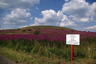
At 927.9 m above sea level (NN) the Dammersfeldkuppe in Bavaria is the second highest mountain after the Wasserkuppe in the Rhön, a low mountain range straddling the states of Bavaria, Hesse and Thuringia in Germany.

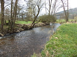
The Sinn is a river that flows through the state of Hesse and the Bavarian province of Lower Franconia in southern Germany. It is about 69 kilometres (43 mi) long and is a right, northerly tributary of the Franconian Saale.

The Mümling is a river of Hesse and Bavaria, Germany. It is 49.7 kilometres (30.9 mi) long and lends its name to the Mümlingtal in Odenwald. In Bavaria it is sometimes called Mömling in official documents. It is a left tributary of the Main.

The Kahl is a river in the northern Spessart in Bavaria and Hesse, Germany. It is a right tributary of the Main and is 35.6 km (22.1 mi) long. The name Kahl comes from the Old High German word kaldaha, which means cool and clear. The Kahl rises from two sources left and right of the road at the foot of the Spessart hills, near Kleinkahl. These springs produce 50–60 litres per second. The Kahl flows into the river Main in Kahl am Main. The mouth is near the old Kahl Nuclear Power Plant. The largest tributaries are Westerbach, Sommerkahl, Reichenbach and Geiselbach.

Lohr is a right tributary of the Main in Germany. Although its origins lie in the Main-Kinzig district of Hessen, most of the course of the Lohr is in the Main-Spessart district of Bavaria. Including its source river Lohrbach, it is 23.0 km long.

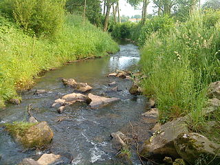
The Aura is a 13.3 kilometres (8.3 mi) tributary of the Sinn River in Bavaria, Germany.

Gersprenz is a river that starts in the Odenwald, Hessen and flows into the river Main near Aschaffenburg, Bavaria, Germany. Including its source river Mergbach, it is 62.1 km (38.6 mi) long, without the Mergbach it is 51.3 km (31.9 mi) long.

Welzbach is a river of Hesse and Bavaria, Germany. It is a left tributary of the Main at the district Leider of Aschaffenburg.
The Westerbach is a right tributary of the Kahl in the northern Spessart in Lower Franconia, Bavaria, Germany.
Döllbach is a river of Bavaria and Hesse, Germany. It flows into the Fliede near Eichenzell.