Schonauwen

Last updated
Municipality of Houten in 1868, with Schonauwen coloured brown. Heerlijkheden Houten.png
Municipality of Houten in 1868, with Schonauwen coloured brown.

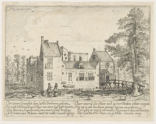
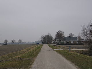
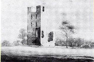
Schonauwen is a former castle in the Dutch province of Utrecht. It is located on the southern outskirts of the town of Houten, surrounded by new buildings.

Netherlands Constituent country of the Kingdom of the Netherlands in Europe

The Netherlands is a country located mainly in Northwestern Europe. The European portion of the Netherlands consists of twelve separate provinces that border Germany to the east, Belgium to the south, and the North Sea to the northwest, with maritime borders in the North Sea with Belgium, Germany and the United Kingdom. Including three island territories in the Caribbean Sea—Bonaire, Sint Eustatius and Saba— it forms a constituent country of the Kingdom of the Netherlands. The official language is Dutch, but a secondary official language in the province of Friesland is West Frisian.

Utrecht (province) Province of the Netherlands

Utrecht is a province of the Netherlands. It is located in the centre of the country, bordering the Eemmeer in the north-east, the province of Gelderland in the east and south-east, the province of South Holland in the west and south-west and the province of North Holland in the north-west and north. With an area of approximately 1,400 square kilometres (540 sq mi), it is the smallest of the twelve Dutch provinces. Apart from its eponymous capital, major cities in the province are Amersfoort, Houten, Nieuwegein, Veenendaal, IJsselstein and Zeist.

Houten Municipality in Utrecht, Netherlands

Houten is a municipality in the Netherlands, in the province of Utrecht.

Until the end of the 18th century, Schonauwen was a separate heerlijkheid (fiefdom). When the country was divided into municipalities by the French, Schonauwen was added to the municipality of Houten, but it became a separate municipality in 1818. In 1857 it was merged back into Houten. [1]

Heerlijkheid

A heerlijkheid was a landed estate that served as the lowest administrative and judicial unit in rural areas in the Dutch-speaking Low Countries before 1800. It originated as a unit of lordship under the feudal system during the Middle Ages. The English equivalents are manor, seigniory, and lordship. The heerlijkheid system was the Dutch version of manorialism that prevailed in the Low Countries and was the precursor to the modern municipality system in the Netherlands and Flemish Belgium.

The heerlijkheid and municipality covered an area of about 6.8 km2, and had about 240 inhabitants in the middle of the 19th century. [2]

Castle Schonauwen

The castle is now owned by the family Schmidt.

Related Research Articles

Susteren City in Limburg, Netherlands

Susteren is a city in the Dutch province of Limburg. It is located in the municipality of Echt-Susteren, about 7 km northwest of Sittard. It was a separate municipality until 2003, when it was merged with Echt. Susteren received town privileges in 1276.

Wijhe is a village in the Dutch province of Overijssel. It is located in the municipality of Olst-Wijhe and is situated about 12 km south of Zwolle on the banks of the river IJssel.

Bronkhorst Place in Gelderland, Netherlands

Bronkhorst is a village in the municipality of Bronckhorst, Gelderland, the Netherlands. Technically, it is a city and with only 157 inhabitants (2010), it is one of the smallest cities in the Netherlands.

Bredevoort City in Gelderland, Netherlands

Bredevoort or Brevoort is a small city with Town privileges of about 1600 inhabitants, located in the municipality of Aalten, Netherlands. It is situated between the towns of Aalten and Winterswijk.

Zuid-Polsbroek was a semi-sovereign or free and high fief, now part of Polsbroek in the Dutch province of Utrecht. Zuid-Polsbroek was the part of Polsbroek south of the small river Benschopse Wetering.

Beltrum is a small village in the region called Achterhoek in the province of Gelderland in the Netherlands.

Schalkwijk, Utrecht Village in Utrecht, Netherlands

Schalkwijk [ˈsxɑɫkʋɛik] is a small village in the Dutch province of Utrecht. It consists of a small village centre on the railway line between Utrecht and 's-Hertogenbosch and a 5 km long ribbon of farms along the small channel Schalkwijksche Wetering.

Oud-Wulven buurtschap in Utrecht, Netherlands

Oud-Wulven is a hamlet in the Dutch province of Utrecht. It is located just north of the village of Houten, and is part of that municipality.

Heemstede, Utrecht Place in Utrecht, Netherlands

Heemstede is a hamlet in the central Netherlands. It is located 3 km west of Houten, Utrecht. The hamlet is known for Heemstede Castle (1645).

Bommenede former town and former municipality in Zeeland

Bommenede or Bommenee is a former island, village, and municipality in the Netherlands, located about 5 km east of the city of Brouwershaven.

s-Gravesloot former municipality in the Dutch province of Utrecht

's-Gravesloot is a former hamlet and municipality in the Dutch province of Utrecht. It was located between Kamerik and Woerden.

Rhijnauwen

Rhijnauwen is a castle, former heerlijkheid (fiefdom), and former municipality in the Dutch province of Utrecht. It was located northwest of the village of Bunnik.

Berkenrode

Berkenrode, or Berckenroode is a former 'Heerlijkheid' in the Dutch province of North Holland, situated on the southwest side of Haarlem on the leidsevaart, north of Iepenrode and west of Heemstede. The original castle Berkenrode in the center of the moat was burned by the Spanish during the siege of Haarlem in 1572. The castle was rebuilt and despite suffering another fire in 1747 the settlement continued to function as a separate municipality with its own chapel up to 1857, when the town was annexed by Heemstede. The town archives are now kept at the North Holland Archives in Haarlem.

Benthorn Hamlet in South Holland, Netherlands

Benthorn is a hamlet in the Dutch province of South Holland. It is located in the municipality of Alphen aan den Rijn, about 2 km east of the centre of Benthuizen.

Vliet, Utrecht human settlement in the Netherlands

Vliet is a hamlet in the Dutch province of Utrecht. It is located about 1 km southwest of the city of Oudewater, on the south bank of the Hollandsche IJssel.

Vrijhoef en Kalverbroek human settlement in the Netherlands

Vrijhoef en Kalverbroek is a former heerlijkheid (manor) and municipality in the Dutch province of South Holland. It was located about 3 km east of the city of Gouda, in the current municipality of Reeuwijk. The area of the former municipality is now almost completely covered by the lakes of the Reeuwijksche Plassen.

Vrijhoeven is a former hamlet and former municipality in the Dutch province of South Holland. It is located about 2 km south of the village of Ter Aar.

De Lek was a heerlijkheid (manor) and municipality in the Netherlands, located in the province South-Holland. It is named after the Lek River.

Pothuizen is a former village in the Dutch province of Utrecht. It was located on the Lek river north of Culemborg, and stretched along the Lek dike on both sides of the Schalkwijkse Wetering.

References

  1. Ad van der Meer and Onno Boonstra, "Repertorium van Nederlandse gemeenten", KNAW, 2006.
  2. Abraham Jacob van der Aa , "Aardrijkskundig woordenboek der Nederlanden", vol. 10 (S), 1847 .

Coordinates: 52°01′N5°11′E / 52.017°N 5.183°E / 52.017; 5.183

Geographic coordinate system Coordinate system

A geographic coordinate system is a coordinate system that enables every location on Earth to be specified by a set of numbers, letters or symbols. The coordinates are often chosen such that one of the numbers represents a vertical position and two or three of the numbers represent a horizontal position; alternatively, a geographic position may be expressed in a combined three-dimensional Cartesian vector. A common choice of coordinates is latitude, longitude and elevation. To specify a location on a plane requires a map projection.